Stinging Fork Falls
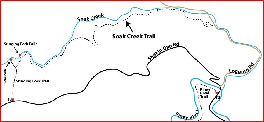
Stinging Fork to Shut in Gap Road
Overview
North bound through hikers emerging from the Piney River segment will turn left on Shut In Gap Road. North bound day hikers will turn right out of the parking lot. Continue a short road walk (900 feet) North to an old logging road at the yellow bar gate on the right. Access to this road is permitted. Follow this road for 1.5 miles to the Stinging Fork trailhead.
Beginning at the yellow bar gate, this 5.8 miles long trail follows Soak and Little Soak Creeks through second and third growth mesophytic forest. This is a strenuous section to hike, but the hiker is rewarded with flora in a variety of habitats from stream margins in the gorge to the Cumberland Plateau at the Northern end of this section.
Wildflowers bloom in abundance from mid April to mid May. Much of the trail feels like it passes through rain forest especially in spring and early summer. Look for a variety of ferns from Maiden Hair to Christmas, partridge berry, jack-in-the-pulpit, and varieties of trillium. In mid May, mountain laurel blooms in profusion in places and in early summer rhododendron blooms.
There are cascades, falls and numerous stone bluffs along the way. These bluffs provide a unique habitat for varieties of fern, moss, stone crop, partridge berry and others. Soak Creek and Little Soak Creek afford many nice spots to step off the trail for lunch or to cool off in the waters.
Trail Section Details
Features:
- Waterfalls
- Overlooks
- Swimming
- Wildflowers
- Fall color
- Bluffs
Counties:
- Rhea
Distance:
5.8 miles
Difficulty:
Strenuous
Elevation Change:
851 ft.
Northern Terminus:
(El. 878′ N35 42.7649 W84 52.77)
Southern Terminus:
(El. 1,734′ N35 42.954 W84 52.77)
Timezone:
CDT
Cautions:
The old logging road beginning at the trail’s Southern terminus has numerous rocky bolder and cobble stretches where one can easily turn an ankle. It drains poorly and in rainy periods can be quite boggy with ponding water. Similar conditions exist at various points along the trail. In late spring and through summer, poison ivy abounds along portions of the trail. Springtime rains can bring high water quickly. These can inundate the trail in the lowest places.
Camping:
There is one authorized camping site along this section of trail at mile 4.5 (1.3). See the trail description for the exact location. Obtain a permit here. There is an old campsite along the old logging road at about mile 1.4 (4.4) that has been used by locals in times past. Use of this campsite for overnight camping is prohibited.
Water Sources:
There are no safe water sources along this section of trail. Bring your own drinking water; filter, boil or sterilize all water used for cooking.
Topographic Maps:
Pennine Quadrangle; Spring City Quadrangle
Trailheads
Driving Directions:
- Traveling North on US Hwy 27 toward Spring City, TN, turn onto the cloverleaf for Hwy 68 West to Shut In Gap Road on the left.
- Traveling South on US Hwy 27 toward Spring City, TN, turn right on Jackson Avenue. Continue on Jackson until it dead ends into TN Hwy 68; turn right onto TN Hwy 68 and then an immediate left onto Shut In Gap Road.
- Traveling East on TN Hwy 68 toward Spring City, TN, turn right onto Shut In Gap Rd.
- Traveling West from Watts Bar Dam on TN Hwy 68 toward Spring City, TN, turn right onto US Hwy 27 then right onto TN Hwy 68 and continue to Shut In Gap Rd. on the left. Turn left onto Shut In Gap Rd.
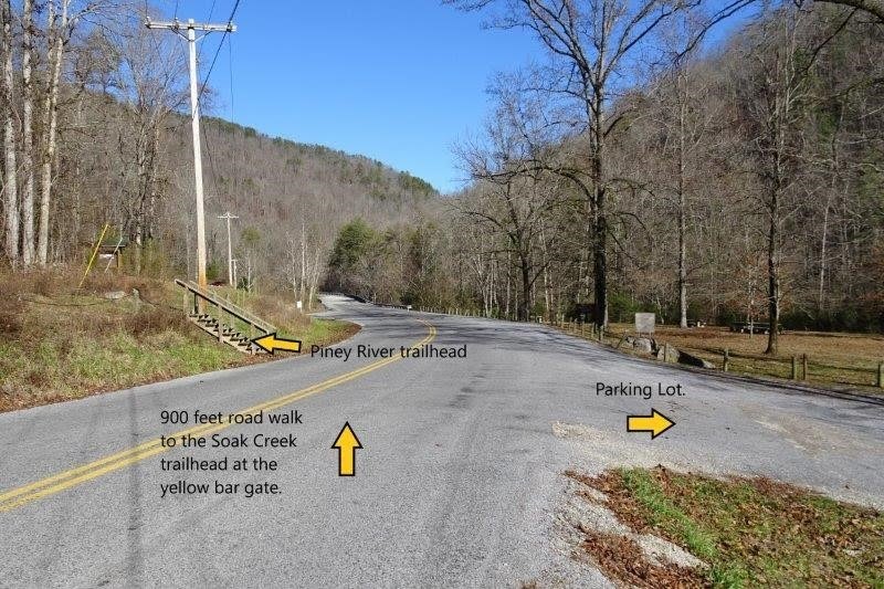
- Once on Shut In Gap Road, continue to the Piney River Management Area/Cumberland Trail State Scenic Trail on the right. Park anywhere in the gravel lot. The Northern terminus of the Piney River section of the Cumberland Trail is directly across Shut In Gap Rd. To reach the Southern terminus of the Stinging Fork Section of the Cumberland Trail, turn right out of the parking area and proceed about 900 feet along Shut In Gap Road crossing the Piney River bridge. From the bridge, you can see the confluence of Soak Creek and Piney River. In the curve in the road beyond the bridge, there is a yellow bar gate on the right. This is an old logging road that provides entry to the Stinging Fork Section of the Cumberland Trail. Note: this road is on private land for over a mile. Access is permitted. However, please practice Leave No Trace on this and all sections.
Day hikers may want to park one car at the Piney River Management Area parking lot near the Piney River trailhead and drive 3.9 miles further up Shut In Gap Road to the trailhead for the connector trail leading to the CT (white blazed). There is adequate gravel paved parking for several vehicles at this parking lot. This affords the option of hiking the trail either North to South from here or South to North from the Piney River Management Area.
Map
Description
Mile 0.0 (5.8) Old logging road. Walk North on Shut In Gap Rd for about 900 feet to the yellow bar gate at the old logging road on the right. This old road is presently (2019) on private property but right of way access to the Cumberland Trail is allowed. Please be aware that you are on private property and treat it with respect.
Follow the logging road to the trailhead. As of 2019, this road is badly eroded with stretches of cobble to negotiate. It can become boggy with pooled water in rainy season. Watch your footing on these stretches.
Mile 0.1 (5.7) Note the large rock bluff typical of this area on your left. Sweet gum trees dominate this area.
Mile 0.3 (5.5) Note the secondary channel of Soak Creek on the right. High waters have created a large island with the main channel on the far side of the island. The road is badly eroded here.
Mile 0.4 (5.4) The road rejoins Soak Creek on the right. About 100 feet farther on there is a nice sandy beach access to the stream.
Mile 0.8 (5.0) Look across Soak Creek to see the confluence of Little Piney Creek with Soak Creek. Note the abundant Mountain Laurel.
Mile 1.0 (4.8) There is a small cascade in Soak Creek on the right. The road is badly eroded here requiring rock hopping for about 300 feet.
Mile 1.1 (4.7) Cross a large flat rock in the middle of the road. Note the huge boulders in the stream on the right.
Mile 1.2 (4.6) Cross a wet weather stream.
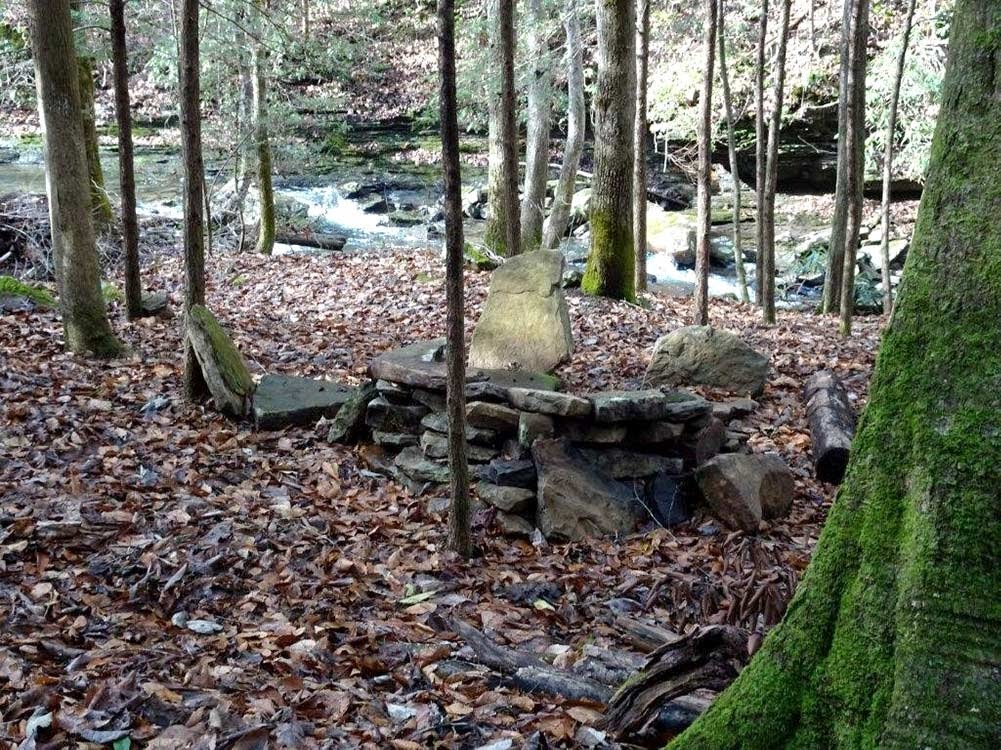
Mile 1.4 (4.4) Primitive Campsite. Locals created this campsite in days past. Overnight camping here is prohibited. Use it for day use only. All back country camping requires a permit. Note the large leaf magnolia growing here. An extensive rock bluff is on the left for the next .1 mile.
Mile 1.5 (4.3) Stinging Fork trailhead. The rock bluff on the left ends and the Stinging Fork Trailhead is about 100 feet ahead at an elevation of 1009 feet. Coordinates: N35.727515, W84.880977. This is the official beginning of the Stinging Fork section of the Cumberland Trail as of 2019.
The trail turns to the left and begins a 275 feet climb in the next quarter mile. Cross three wet weather creeks on stones set by the Cumberland Trails Conference. You will encounter several switchbacks as you climb. Ascend through dense hardwood-hemlock forest. Note the tulip poplar, sweet gum, beech and hemlock. Some of the hemlocks may have a blue paint spot on them. This an indication of a program to monitor the efficacy of treatment against the woolly adelgid infestation.
Mile 1.6 (4.2) The trail veers away from Soak Creek and begins a steep ascent through several switchbacks.
Mile 1.7 (4.1) Stone steps. Continue to ascend to the right on an old logging road.
Mile 1.8 (4.0) Crest the bluff at an elevation of 1,285 feet and begin a steep descent through a series of short switchbacks to a set of stone steps.
Mile 2.0 (3.8) Continue to descend through switchbacks and cross a wet weather creek on stone steps. The old logging road branches away to the left. Continue to the right on the white blazed CT.
Mile 2.1 (3.7) Cross another wet weather stream. Shortly the trail veers to the right toward Soak Creek at an elevation of 1,015 feet. Note the park boundary marker on the right. Veer to the left following Soak Creek.
Mile 2.2 (3.6) Continue with Soak Creek on the right through third growth forest and rhododendron. The trail ascends briefly then descends.
Mile 2.3 (3.5) The trail follows an old logging road for about 100 feet then descends to the right on stone steps through rhododendron. To the right across Soak Creek, is the confluence of Edwards Branch with Soak Creek.
Mile 2.4 (3.4) Cross another wet weather stream.\
Mile 2.6 (3.2) Cross flat stones for about 60 feet then continue on through mixed forest. Note the poplars, hemlocks, holly and mountain laurel.
Mile 2.7 (3.1) The trail joins the remnants of an old not well defined logging road. Note the large white oak on the right.
Mile 3.3 (2.5) Switch back to the right over a wet weather creek and begin to ascend.
Mile 3.4 (2.4) Switch back left. The trail begins a steep ascent.
Mile 3.5 (2.3) The trail crests the bluff and begins to descend.
Mile 3.6 (2.2) Note the impressive rock shelf to the left.
Mile 3.7 (2.1) There is a Stewardship Forest sign on the left as the trail begins to ascend after crossing a wet weather branch.
Mile 3.9 (1.9) Begin a steep descent.
Mile 4.0 (1.8) Stone steps lead to a stream crossing. The trail begins to ascend through switchbacks. Off to the right is the confluence of Soak Creek and Little Soak Creek. As you ascend the trail veers away from Soak Creek and begins to follow Little Soak Creek toward Stinging Fork Falls.
Mile 4.3 (1.5) Cross a small stream.
Mile 4.4 (1.4) After descending, the trail follows an old roadbed with Little Soak Creek and numerous small cascades on the right.
Mile 4.5 (1.3) There is a campsite on the right at N35.720018, W84.920246. Note: overnight camping is by permit only. Practice Leave No Trace. You can obtain a permit online at http://www.friendsofthecumberlandtrail.org/camping/.
Beyond the campsite, the trail ascends briefly. A barely discernible old road bed branches to the left. The trail continues straight ahead and then descends again to Little Soak Creek.
Mile 4.6 (1.2) A wet weather creek tumbles down from the left. Pause for a nice view of the small cascades with a nice pool in the stream. Continue for about 200 feet on a relatively level stretch.
Mile 4.7 (1.1) Begin a steep ascent on stone steps for the next .1 mile.
Mile 4.8 (1.0) Continue ascent on stone steps. Just beyond the stone bluff on the left the trail begins to descend.
Mile 4.9 (0.9) Continue to descend to Little Soak Creek on the right.
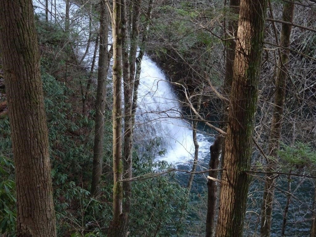
Mile 5.0 (0.8) Intersect the Stinging Fork Falls Trail (yellow blazes) which continues straight ahead toward Stinging Fork Falls. If at all possible, take time to walk this .1 mile side trail to the falls. After viewing the falls, return to the main trail.
The elevation at this point is 1,523 feet. The CT with its white blazes turns left and begins to ascend and in about 200 feet encounter the first set of wooden stairs. Use caution as these steep steps can fall into disrepair from time to time.
Mile 5.1 (0.7) Look down and to the right for a nice view of Stinging Fork Falls. Cross a boulder field for the next 200 feet.
Mile 5.2 (0.6) The trail continues to ascend through several switch backs. In wet weather, the trail tread becomes very slippery especially on rocky surfaces. Use caution on this narrow section. In about 100 feet encounter the second set of steep wooden stairsteps. Pass a rock shelf on the right and shortly a third set of steep wooden stairsteps before emerging from the gorge onto the plateau.
Mile 5.3 (0.5) On the right, a side trail with yellow blazes leads a short distance out to a rock bluff overlooking the Stinging Fork Gorge. The view is best when foliage is off the trees. The coordinates of this intersection are N35.715206 W84.928631. The elevation at this point is 1,675 feet. The CT with its white blazes continues straight ahead.
Mile 5.6 (0.2) The CT intersects with the connector trail lading straight ahead to the parking lot on Shut In Gap Road. This is the Northern terminus of the Stinging Fork Falls section and the Southern terminus of the Head of Sequatchie section. The main CT turns sharply right and continues on toward Hinch Mountain and Head of Sequatchie. Continue straight ahead for .2 mile to the Shut In Gap Rd. parking lot.
Mile 5.8 (0.0) Parking lot and connector trailhead on Shut In Gap Road leading to the Northern terminus of the Stinging Fork Falls section of the Cumberland Trail. From here you can hike South along the Soak Creek/Stinging Fork section or hike North toward Hinch Mtn. and Head of Sequatchie.
— Frank Jamison, CTC Board Member
More Information
The Stinging Fork Section is often referred to as the Soak Creek Section.