Signal & Edwards Points
Signal Point to Suck Creek Rd (TN 27)
Overview
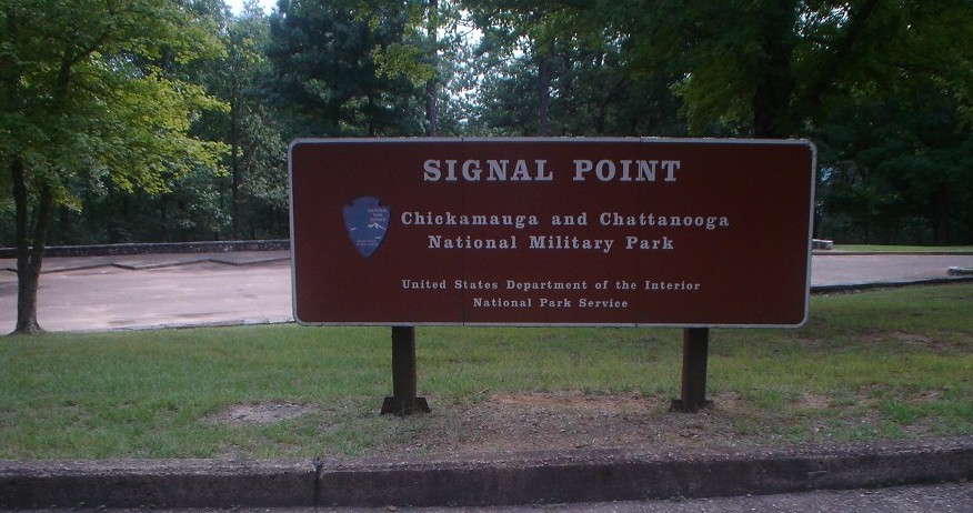
The Signal & Edwards Points Section serves as the southern terminus of the Cumberland Trail. It begins at Signal Point Park, part of the Chickamauga and Chattanooga National Military Park, from the overlook, the trail descends into Middle Creek Gorge and passes into the small Rainbow Lake Wilderness Area owned by the town of Signal Mountain. Crossing Middle Creek, the trail enters Prentice Cooper State Forest and Wildlife Management Area (WMA). The trail ascends out of the gorge to then follow the plateau rim, affording multiple overlooks of the Tennessee River Gorge. At Mushroom Rock, the trail drops into the North Suck Creek Gorge, crossing this creek on a suspension bridge, and eventually emerging on Suck Creek Road (TN27).
Highlights include Signal Point; an overlook of Julia Fall (wet-weather waterfall); Lockhart’s Arch, among other rock formations; and Edwards Point with its spectacular view of the Tennessee River Gorge.
Trail Section Details
Features:
- Waterfalls
- Overlooks
- Wildflowers
- Fall color
- Bluffs
Counties:
- Hamilton
Distance:
8.4 miles
Difficulty:
Strenuous
Elevation Change:
400 feet
Northern Terminus:
Suck Creek Road (N35 09.172, W85 23.698)
Southern Terminus:
Signal Point, Chickamauga and Chattanooga National Military Park (N35 07.224, W85 21.996)
Timezone:
Eastern/Central
Cautions:
Steep bluffs and rough rocky terrain, slick rock sections
Camping:
Shelter @ Lockhart’s Arch Campsite at mile 1.8 (6.6), and the North Suck Creek Campsite at mile 7.0 (1.4)
Seasonal Notes:
Lack of water in drought seasons
Water Sources:
Very reliable seasonally
Trailheads
The southern end of the trail is accessible from US-127. From Chattanooga on US 27 north, take the US 127 exit up Signal Mountain for 4.3 miles. Just at the top of the mountain, turn left onto Mississippi Avenue before the stoplight (the Jamestowne condominium complex will be on your left). At the first stop sign (0.1 mile) cross Maryland Avenue, and continue on Mississippi Avenue to its merger with James Blvd (0.7 mile). Follow James Blvd 0.1 mile to Signal Point Road and turn left. Signal Point Road dead-ends in the paved parking area for Signal Point (0.25 mile).
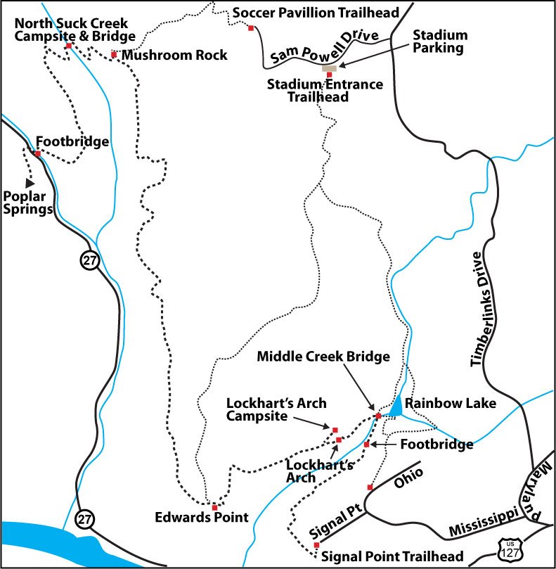
Map
Description
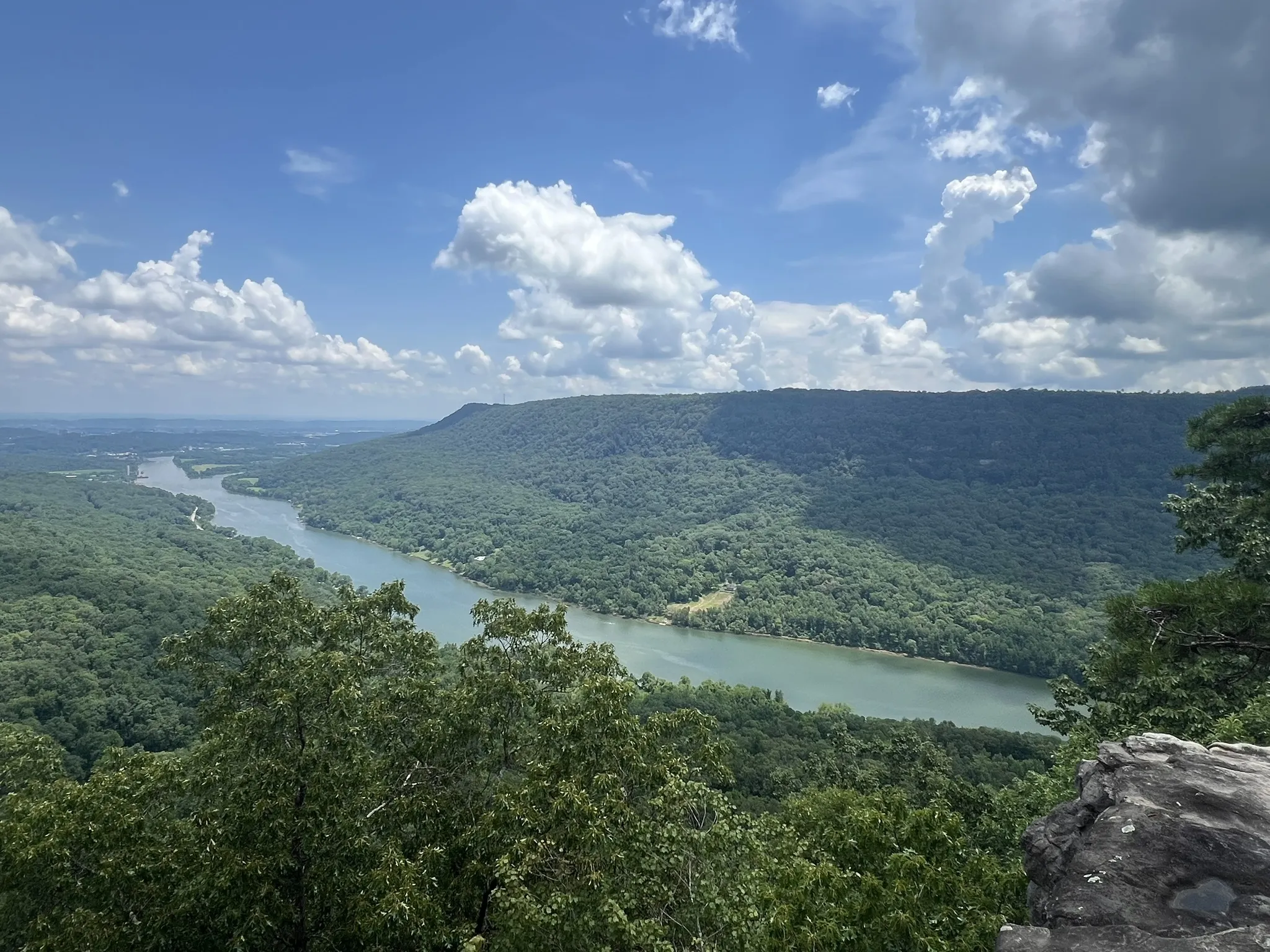
Mile 0.0 (8.4) At the Signal Point parking area, follow the paved pathway to the overlook and take in the panoramic view of the Tennessee River Gorge. Follow the rock wall all the way to the right past the split rail fence and through a chain-link fence to where the trail begins its 200-foot drop into Middle Creek Gorge. Descend a series of ramps and staircases (known to its builders as the “mousetrap”) constructed in 1998 as an Alternative Spring Break project to protect this fragile rock slope. These steps can be slippery in the winter months and any time when wet.
Mile 0.2 (8.2) Boulders and rocks are scattered down the slope; a few of the blazes mark an original route from 2004, before torrential rains washed it away and necessitated a reroute.
Mile 0.4 (8.0) Julia Falls Overlook—another view of the river gorge. The 95-foot falls, with adequate rainfall, is visible straight ahead across the Middle Creek Gorge. Julia Falls is named for the daughter of Sam Powell, one of the Cumberland Trail’s founders. Sam took his daughter along on a trail-routing trip in the early 1960s. Julia discovered the overlook and first saw the falls when she went on ahead of her dad to do some exploring of her own. Edwards Point is also visible from the overlook, across the gorge and to the left of the waterfall.
Mile 0.9 (7.5) Rainbow Falls is below on the left. (Caution: there is no trail accessing the base of the 40-foot falls; please stay on the trail.) Poison ivy is prolific here during the summer months; so long pants are advised.
Mile 1.1 (7.3) Turn left below the large boulder. Once at the bottom of this rocky descent, you should begin hearing Middle Creek. The yellow and white Japanese honeysuckle blooms here in spring.
Mile 1.2 (7.2) A wooden suspension bridge crosses a washout. Renovations were done on this bridge by CTC staff & volunteers in September 2010 as a National Public Lands Day project.
Mile 1.3 (7.1) Enter a cool, shady hemlock grove. Some seasonal seeps keep the ground wet enough for crested dwarf iris to be abundant. Trillium are among the first to bloom, heralding spring.
Mile 1.4 (7.0) The trail crosses Middle Creek Bridge. This 100-foot suspension bridge is the fourth bridge constructed over Middle Creek; the first (built 1979) and second (1997) were washed away by floods. When a large dead pine felll across the third bridge (2013) the steel towers held fast, but some of the cable and the decking had to be replaced. The iron footings from the first bridges are still visible in the boulders mid-creek. Looking upstream, you can see the Rainbow Lake dam, built circa 1916 as part of the Signal Mountain Hotel (now the Alexian Inn).
The bridge over Middle Creek is shared with the Rainbow Lake Loop trail (blazed blue), a 2.3-mile loop through the Rainbow Lake Wilderness Area. This 239-acre wilderness area belongs to the Town of Signal Mountain and is maintained by the town’s parks board. Before crossing the bridge, you can continue upstream following the blue blazes 0.7 mile to the Ohio Avenue parking lot. Another option is to cross the bridge and follow the blue and orange blazes upstream for 0.3 mile (also called the “Bee Branch Trail”), cross a second bridge back over the creek and follow the blue blazes for 1.3 miles from there up to the same Ohio Avenue lot.
Yet a third option is to cross the Middle Creek Bridge, follow the blue and orange blazes to the second bridge, but continue straight (do not cross the bridge) on the orange-blazed trail to Shackleford Ridge Park, a Hamilton County Park. The entire orange option is a very rough and rocky 2.8 miles that passes beneath bluffs that make it an ideal winter hike (but watch for falling icicles in warming weather).
The trailhead for the other end of the orange-blazed trail is behind the football stadium at Signal Mountain Middle/High School, coordinates are N 35 09.542 W 085 21.942. Walking in from that direction, the trail splits in about one and a half miles into the orange trail to the left (Middle Creek/Rainbow Lake) and a yellow trail to the right (see Edwards Point, Mile 2.85). The initial mile and a half is blazed with both colors.
To continue on the Cumberland Trail, cross Middle Creek Bridge; notice hemlocks in this area are being affected by the hemlock wooly adelgid. On the other side, follow the creek upstream 370 feet, take the switchback to the left, and begin a 200-foot climb out of the gorge towards Edwards Point.
(Caution: Middle Creek has tested positive for E-Coli. Swimming in or drinking from the creek without treating is not advised. For those planning to spend the night in the Lockhart’s Arch Campsite, you should fill your water bottles here, but the water must be filtered or otherwise purified.)
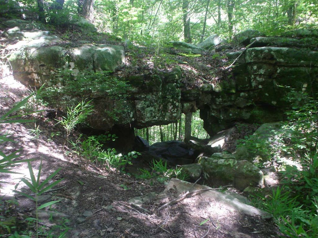
Mile 1.6 (6.8) Massive limestone bluffs are on the right, including Middle Creek Arch #1 (7 feet by 3 feet) and the larger Middle Creek Arch #2 (20 feet by 8 feet). An unmarked side trail leads 300 feet to the arches. In late April and May, the trail is lined with star chickweed.
Mile 1.7 (6.7) The trail turns right and passes up through a gap between boulders. Watch for the white blazes on the boulders marking this rocky ascent and for fire pink blooming among the rocks in early May.
Once you’ve navigated this climb, it’s just another 200 feet to Lockhart’s Arch. The arch is named for three boy scouts (brothers Gary, Greg and Glen Lockhart) in the troop of CT-founder Sam Powell in the mid 1960s. Sent ahead to seek a route out of the Middle Creek gorge, the three youths returned to Sam and proposed a crawl through the arch as an option. The trail now passes by arch, no longer through it.
Mile 1.8 (6.6) Spur to Lockhart’s Arch shelter. This 425-foot spur trail will bring you to Lockhart’s Arch Campsite, with a shelter, constructed as an Eagle Scout project. The shelter is closed on three sides and has a wooden floor and a gear loft. This is the southernmost campsite on the Cumberland Trail. The nearest water source is Middle Creek; this water must be treated.
Mile 2.0 (6.4) From this escarpment, you can see back across Middle Creek Gorge. The next half mile takes you along the rocky escarpment with several overlooks. Pass through a predominantly pine thicket; a fire in 2007 opened the canopy for flowers and shrubs to grow—goldenrod, sunflowers, greenbrier, muscadines, grasses, blackberries (summer), asters (fall), yellow star grass, pinkster azaleas, foam flower (spring), and other under-story plants. In the rainy months, this can be a wet area; several seasonal seeps cross the trail, but there are strategically placed stepping stones.
Mile 2.7 (5.7) The trail makes a sharp right turn away from the escarpment and again becomes rocky as it makes an ascent.
Mile 2.8 (5.6) Lower overlook, and then Edwards Point just ahead, one of the most spectacular views of the Tennessee River Gorge and an excellent lunch spot. The origin of the name remains uncertain, but the point is possibly named for a post-Civil War prospector.
An option here is to take the 3.3-mile (blazed-yellow) trail up an old roadbed into Shackleford Ridge Park. Parking for this option is behind the football stadium at Signal Mountain Middle/High School, coordinates for which are N 35 09.542 W085 21.942.
To continue on the Cumberland Trail, walk 250 feet up the roadbed to a white double blaze and turn left.
Mile 2.9 (5.5) Two overlooks offer excellent views of the Tennessee River Gorge.
Mile 3.1 (5.3) The trail makes a right turn away from the gorge rim.
Mile 3.4 (5.0) Overlook offering view of the North Suck Creek Gorge; the Tennessee River is still visible to the far left. This particular stretch of the river was a challenge for boats to navigate due to eddies and whirlpools; so it was nicknamed “the Suck.” The creek that entered the river at this point was then called “Suck Creek.” The Suck became inundated with lake waters upon completion of Hale’s Bar dam downstream in 1913.
Mile 3.5 (4.9) Trail again makes a right turn away from the rocky escarpment of bluff line and becomes a woodland trail with grasses, greenbrier, sunflowers, scattered scrub cedars, but also poison ivy underneath pines, hickories, and majestic oaks.
Mile 4.0 (4.4) An opening in the trees affords an excellent view of the bluffs of Raccoon Mountain across the gorge.
Mile 4.2 (4.2) Seasonal creek crossing; mountain laurel and rhododendron are plentiful in this moist area and bloom deep pink in late spring. Soon after,
Mile 4.3 (4.1) Another seasonal creek to cross; crested dwarf iris are among the early blooming flowers along its banks.
Mile 4.5 (3.9) Large boulders make crossing this wet-weather creek easier.
Mile 4.8 (3.6) The trail crosses another seasonal creek. Blueberries are abundant along the trail here and for the next mile. Ripe in mid-to-late June, they are also food for birds.
Mile 5.0 (3.4) Plenty of partridgeberry line the banks of this seasonal creek and the trail corridor. Another creek crossing lies 100 feet ahead (also seasonal).
Mile 5.2 (3.2) The trail passes through a grove of holly trees, a favorite perching place for cardinals.
Mile 5.5 (2.9) Slippery when wet, large rocks line this creek bed (usually dry).
Mile 6.2 (2.2) Final creek crossing for this section. The trail passes through a cool and shady hemlock grove.
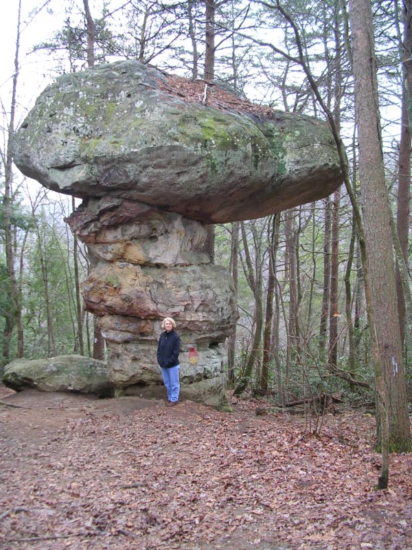
Mile 6.4 (2.0) Mushroom Rock is a 20-foot-high sandstone pedestal rock of the Suwanee conglomerate. Layers are clearly visible along the pedestal where water eroded it away, leaving a lopsided capstone on top.
From here the hiker can follow an old roadbed (as yet unmarked) 1.2 miles to the soccer field parking lot in Shackleford Ridge Park; parking coordinates there are N35 09.766 W 085 22.400; this is a second trailhead in the park about a quarter mile from the Middle Creek/Rainbow Falls/Edwards Point trailhead.
To continue along the Cumberland Trail, take the switchback to the left by Mushroom Rock.
Mile 6.7 (1.7) Rock steps start the trails 300-foot gradual descent into the North Suck Creek Gorge.
Mile 6.9 (1.5) The trail runs along the base of a bluff line amid a veritable fern garden.
Mile 7.0 (1.4) North Suck Creek suspension bridge. Built in 1979, this 225-foot suspension bridge spans the creek. North Suck Creek Campsite is on the near end. During summer months the creek may be reduced to a trickle; all water here should be treated before drinking.
From this point, a proposed future route of the Cumberland Trail will head north and will be called the North Suck Creek Section. The CT will follow North Suck Creek to Lewis Creek, then east to Chicken Hollow and Maple Branch Roads. The hiker will then have a road walk along Maple Branch Road to US 127. Until that route has been determined, stay with the existing trail.
Once across the suspension bridge, the trail switchbacks up 400 feet out of the gorge. Lady slippers and little brown jugs line the trail in spring, along with occasional squawroot.
Mile 7.5 (0.9) The trail passes through a gap between a boulder and the bluff and levels out. During the spring months, buckeye shrubs bloom red, pink, and off-white along here.
Mile 7.6 (0.8) Note the sinkhole on the right side of the trail and the interesting underground rock formation.
Mile 8.1 (0.3) Begin a gradual rocky descent.
Mile 8.2 (0.2) A natural rockhouse opens on the right. Morning glories can be seen blooming here in the late summer months.
Mile 8.4 (0.0) Cross a 50-foot bridge over South Suck Creek. North and South Suck Creeks form Suck Creek where they merge down the mountain. Soon after, take the steps up to a guardrail and climb over onto the shoulder of Suck Creek Road. To continue on the existing trail, turn right and walk 100 yards up the road and cross to a set of steps and the beginning of Poplar Spring Trail on the left. A pullout for parking is 0.6 mile above this crossing.
(Backpackers: the next campsite is Poplar Springs, 1.6 miles ahead. The water source there is seasonal, so fill your water bottles here. This water must also be filtered or treated.)
Description provided by Caroline Woerner, CTC Board Member
More Information
Campsites
Lockhart’s Arch Campsite, with a shelter, constructed as an Eagle Scout project. The shelter is closed on three sides and has a wooden floor and a gear loft. This is the southernmost campsite on the Cumberland Trail. The nearest water source is Middle Creek; this water must be treated.
North Suck Creek Campsite is on the near end of the North Suck Creek suspension bridge. During summer months the creek may be reduced to a trickle; all water here should be treated before drinking.