Obed River
Nemo Bridge to Devil’s Breakfast Table
Overview
Most of the Obed River Section is within the 82,000-acre Catoosa Wildlife Management Area (WMA) located in Cumberland and Morgan Counties, which is managed by the Tennessee Wildlife Resources Agency (TWRA). The stretch of trail northeast from Devil’s Breakfast Table for 8 or so miles was constructed with the help of Morgan County Regional Correctional Facility and CTC volunteers. The remaining trail to Alley Ford was built by CTC, and Breakaway™ college student volunteers. From Alley Ford to Nemo Bridge is within the Obed Wild and Scenic River federal lands managed by the National Park Service, and is sometimes referred to as the “Nemo Bridge Trail.”
Time Travel Alert: Be aware that the southern trailhead at Devil’s Breakfast Table is in Central Time and the Nemo Bridge Trailhead at the north is in Eastern Time. Hikers relying on cell phones to tell time are libel to pick up signals from towers in both time zones. Carry a conventional watch.
This section of the Cumberland Trail is rated difficult due to the many climbs in and out of the Daddys Creek and Obed River Gorges. Because of the many rock steps along the section, the trail was given the name “trail of a thousand steps” by a group of spring BreakAway™ students who worked on the trail. Highlights include views from overlooks, rock formations, and swimming holes.
Approximately six additional miles of the Cumberland Trail are under construction as of 2016 on the west side of Daddys Creek from Devil’s Breakfast Table heading south to Peavine Road.
Hikers Caution
Observe hunting calendar before hiking in Catoosa WMA. According to the 2016-2017 TWRA Hunting Guide, page 56, Catoosa WMA is now open year-round for through hiking on the Cumberland Trail. This is a significant change from previous policy. However, hikers may not drive into the Catoosa WMA during hunting days. Access on hunting days is only by the current trailhead at Nemo Bridge.
Hikers must wear florescent clothing to maintain visibility to hunters in the area during hunting seasons.
Hunting Seasons: In general, hunting dates follow this schedule: Mid-October through December various long weekends (Fri – Sun) February and March for all users (roads are gated, not allowing motorized vehicles). And April to first week of May, on most days. Hikers may NOT drive into Devil’s Breakfast Table trailhead during any hunting day.
For specific hunting dates in Catoosa WMA, contact the Region III WMA Office at 1-800-262-6704. or down load the Hunters guide from the TWRA web site HERE.
Trail Section Details
Features:
- Swimming
- Wildflowers
- Fall color
Counties:
- Morgan
Distance:
14.1 miles
Difficulty:
Strenuous
Elevation Change:
1,200 feet gain and loss
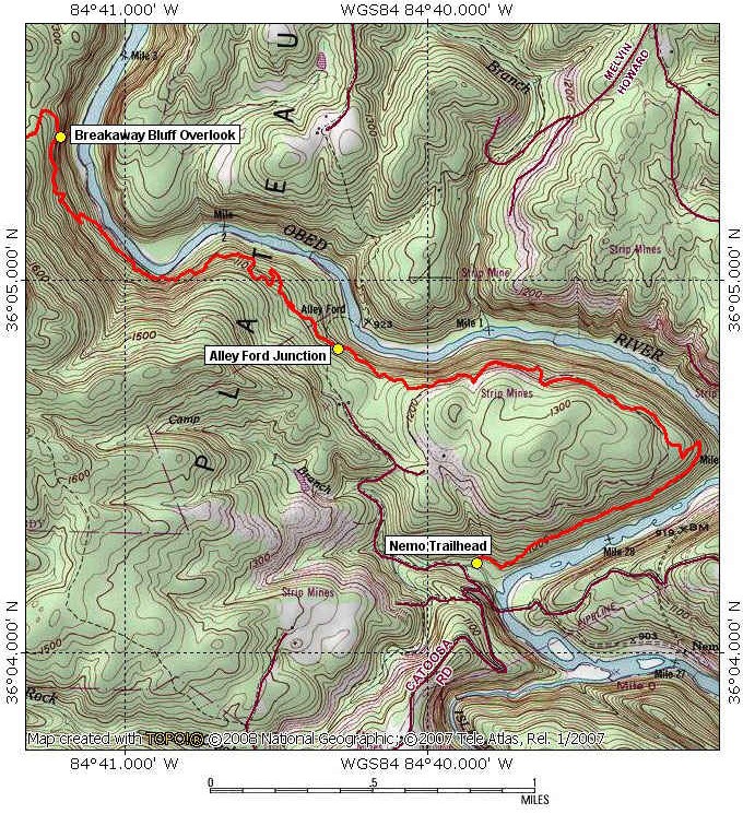
Northern Terminus:
Nemo Trailhead in Rock Creek Campground (N36°04.242 W84°39.880) or Nemo Picnic Area and River Access (El. 919′ N36 04.135 W84 39.674) (Trailhead is in Eastern Time Zone)
Southern Terminus:
Devil’s Breakfast Table Trailhead on Firetower Road at (El. 1,266′ N36°03.523 W84°47.548) (Trailhead is in Central Time Zone) No overnight parking.
Timezone:
EDT & CDT
Cautions:
Many ascents and descents on loose rock steps; tall ledges at overlooks. Florescent, high visibility clothing required in this area.
Camping:
Alley Ford at Mile 11.7 (2.4), Rock Creek Campground at Mile 14.1 (0.0), no back country camping is permitted in Catoosa WMA
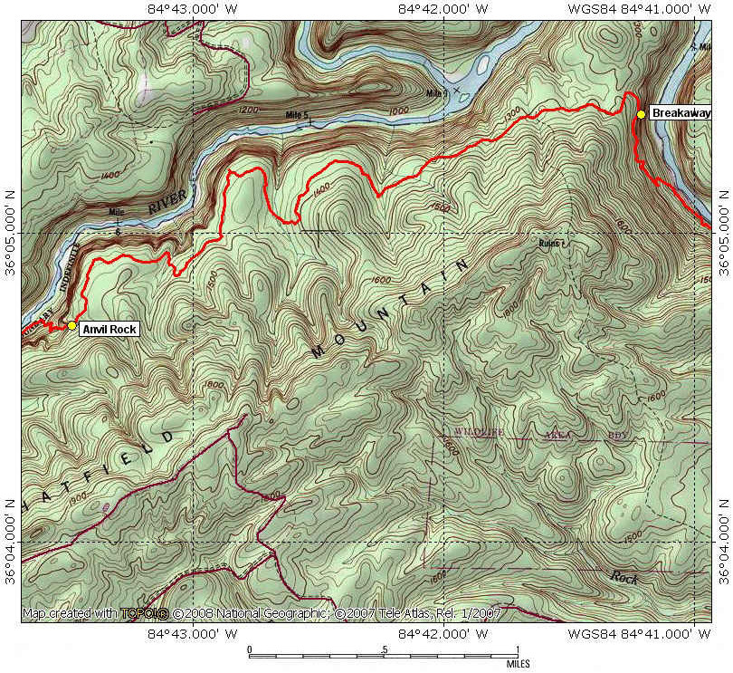
Topographic Maps:
Hebbertsburg and Lancing Quadrangles
Trailheads
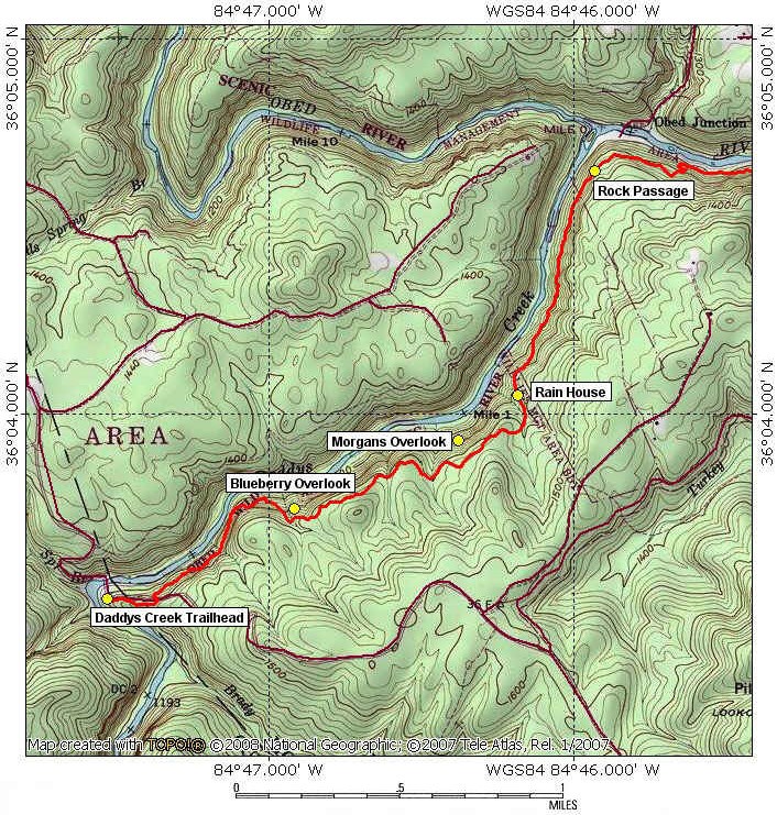
The Daddys Creek Trailhead at Devil’s Breakfast Table represents the southern terminus of the Obed Wild and Scenic River Segment. No overnight parking.
The southern end of this section can be reached by entering the Catoosa WMA on Firetower Road. Take I-40 Exit 322, go north on Peavine Road/101 North for 1.8 miles to Firetower Road. Turn left on Firetower Road where you will see the high voltage power lines on your left. Firetower Road is a paved road for 3.5 miles and then becomes packed gravel when you approach the Catoosa WMA entry. The main roads in the Catoosa are graveled but suitable for passenger cars. Proceed another 11 miles after entering the WMA to Daddys Creek and the Devils Breakfast Table. (Note: Fire Tower Road turns into Otter Creek Road shortly after entering Catoosa WMA). Cross a sturdy 120-foot one-lane bridge with wood decking and no guardrails over Daddys Creek. Graveled parking is on the right with room for about a dozen vehicles at Daddy’s Creek Trailhead. Trailhead is about 200 feet farther up the dirt road. The trail with two big boulders across from the parking area is not he CT. This area is also popular with people swimming and fishing during the summer months. (Note: Fire Tower/Otter Creek Road becomes Hebbertsburg Road after crossing the bridge over Daddys Creek.)
Alternative Route: If the bridge is closed due to high water or maintenance, you can take another route by I-40 Exit 322, go north on Peavine Road/101 North five miles to Fairfield Glade. Continue to a four-way stop and go straight. Soon afterwards 101 ends and road becomes Peavine. Continue five more miles and veer left on Hebbertsburg Road (there is no road sign). You will drive three miles to the Catoosa WMA entry where the road becomes gravel. Go one mile and turn left on Hebbertsburg Road (no sign) and drive 2.5 miles to Devils Breakfast Table and Daddy’s Creek Trailhead parking.
The northern end of this section can be reached from Wartburg on Catoosa Road to Nemo Bridge. Take I-40 Exit 347 and go north on Hwy 27 through Harriman. Continue 19 miles to Wartburg. Follow the Justin P. Wilson Cumberland Trail and Obed Wild & Scenic River National Headquarters signs on Main Street. Turn left at Main and Maiden (right to visit the OWSR Headquarters) and continue 5.5 miles to the Nemo Picnic Area and River Access parking or cross Nemo Bridge and turn right to Rock Creek Campground and the Nemo Trailhead.
To set up a shuttle, hikers can drive through the Catoosa WMA to either trailhead. From the Daddy’s Creek Trailhead, go east on Hebbertsburg Road (Note: This is Firetower/Otter Creek Road you were on) for 2.5 miles to a road intersection and turn left on Nemo Road (this is a gravel road with no road sign). Continue seven miles through Catoosa WMA and turn left at intersection with large sign to exit the WMA on Nemo Road. Drive an additional two miles to the Rock Creek Campground and Nemo Trailhead on the left or continue across the bridge to the Nemo Picnic Area and River Access parking.
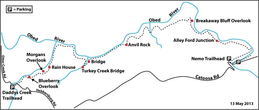
Map
Description
Mile 0.0 (14.1) On the west side of Daddy’s Creek and north of the bridge stands the rock formation called “Devil’s Breakfast Table,” a large flat rock balanced on a column of rock on the cliff overlooking the creek splashing through rapids. The Table is easier to see in winter when the surrounding trees have no leaves. The rock formation is said to have been named by one of the first settlers to the area in the early 1800s who said “Only the Devil would eat breakfast on a table like that,” referring to how it seems that the tabletop rock is barely balanced on the supporting rock and might at any moment tip over. This and other rock formations along the trail are caused by the erosion of underlying weaker rock that leaves the more durable sandstone on top.
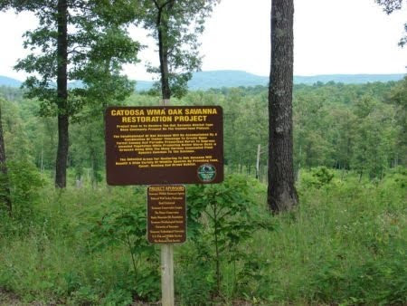
From the Daddys Creek Trailhead, hike 200 ft up the road and enter straight into woods where posts are placed in the ground. The Cumberland Trail mileage sign is located 50 ft up the trail and then the trail kiosk in another 100 ft. This upland area of the Cumberland Plateau has many dead pine trees standing or fallen due to a pine beetle infestation; estimates are that from 1996 to 2000 over 10,000 acres were affected by the infestation. When some of these affected areas were logged and burned, the sites revealed the presence of native warm season grasses that appeared with the increased sun exposure. TWRA is in the process of converting many of these areas to an oak savanna, such as it was many years before European settlers arrived. The restoration of the oak savanna will create habitat for wildlife and improve the soil. As you come into Catoosa along Firetower Road, information signs identify these areas.
Mile 0.2 (13.9) The trail comes out on Firetower Road; go left 70 ft and enter woods across the road. Make a steep descent on the first of many rock steps through Daddy’s Creek Gorge built by Morgan County Regional Correctional Facility inmates and CTC volunteers. The trail below the bluff through the ravine forest of the creek and river gorges is much different from the upland trail. The tall sandstone bluffs that you pass provide shade for hemlock and rhododendron to grow and flourish in the recessed coves. The rhododendron are full of blooms in June. The sandstone rock is also good building material for the many rock steps along this section. It will quickly become apparent why this segment is rated difficult and was given the name “trail of a thousand steps” by students on one of the first Spring BreakAway programs that worked in this section. The trail stays below the bluff for the next 0.7 mile.
Mile 0.4 (13.7) Cross a rock field formed by sandstone that sheers off the bluff. These talus slopes of rock are usually found at breaks in the bluff wall or along water drainages.
Mile 0.6 (13.5) Cross a small drainage.
Mile 0.7 (13.4) A “rock house” is on the right. This is the first of many rock shelters as the trail skirts below the bluff. Rock houses are formed when weaker rock erodes from the underside of the harder sandstone cap rock. These can be small pockets or large rooms found below the rim of the plateau. The first inhabitants of hunter/gatherers lived in these rock houses. Later more advanced tribes, with developed agriculture, used the region as a seasonal hunting and fishing ground and often camped in these shelters. The plateau was so valued for its rich game resources, the Shawnees, Chickasaws, Choctaws, and Cherokees often disputed over hunting rights. When the white man arrived, long-hunters also used the rock houses as shelter. Law prohibits digging for arrows or artifacts in any of these shelters because it destroys the archaeological record.
Mile 0.9 (13.2) Ascend rock steps through a break in the bluff created by a drainage that the trail crosses. Continue a gradual switchback climb.
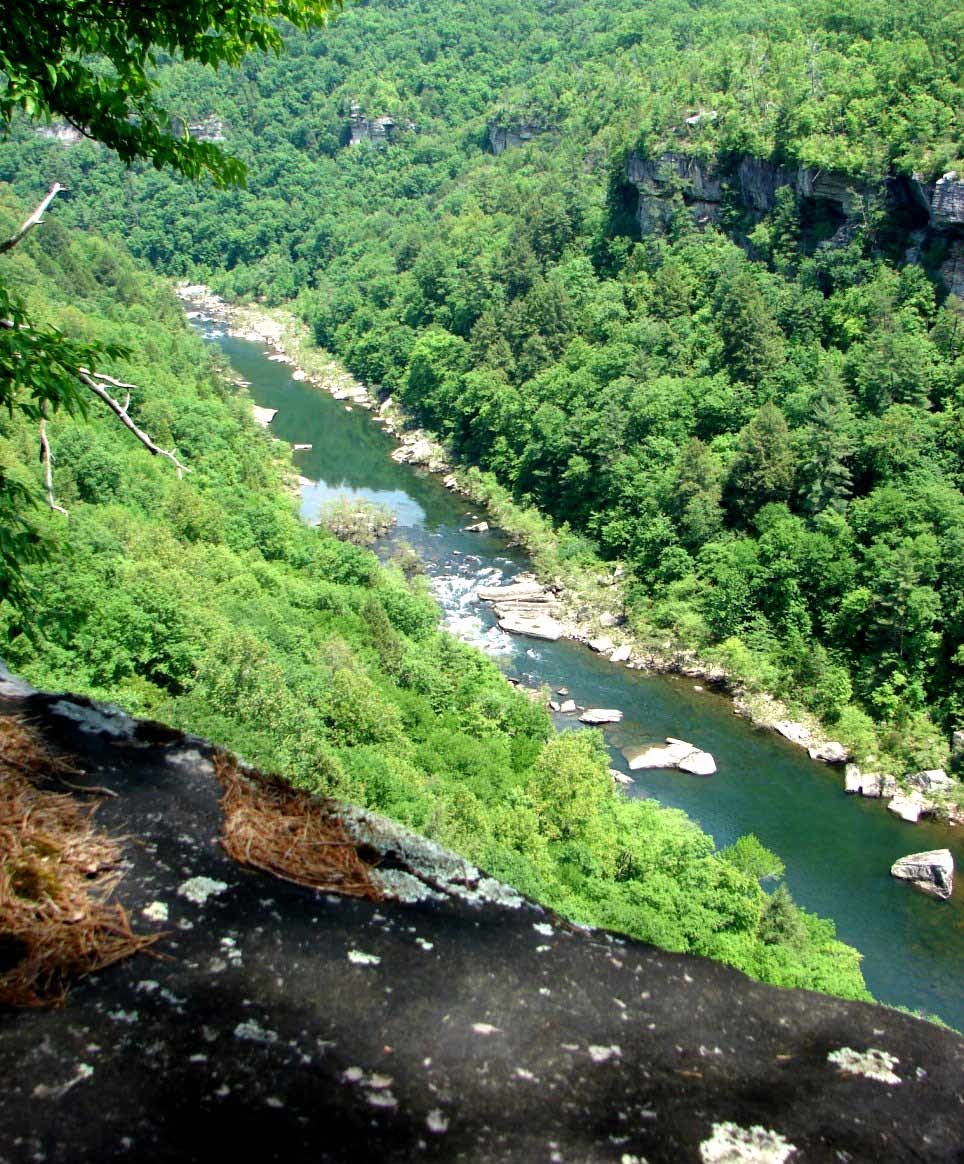
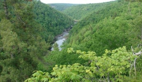
Mile 1.0 (13.1) At a trail intersection, a side path on the left leads 170 feet to Blueberry Bluff. Mountain laurel and blueberry bushes grow on both sides of the trail. Daddy’s Creek Gorge can be seen from the overlook; the creek drains eastward to the Obed River.
Return to the main trail and continue through the upland forest along the bluff. This forest is a mix of tulip poplar, holly, red maple, white oak, hickory, and walnut. The nuts from oak, hickory, and walnut provide a food source for the wildlife found on plateau area. The upland trail is easier to travel with a few small climbs in and out of minor drainages for the next mile.
Mile 1.6 (12.5) The trail reaches another side trail on the left that leads 400 ft to Morgans Overlook with views north up Daddy’s Creek Gorge. The trail is lined with mountain laurel that blooms in May and June.
Mile 1.9 (12.2) Moderately descend to below the bluff wall through a break. The large rock shelter that you come to is the Rain House; it was given the name by volunteers building the trail who sought refuge from rain on many occasions. The Rain House is the largest rock shelter on this section of trail.
Mile 2.5 (11.6) Cross a rocky drainage.
Mile 2.7 (11.4) Pass another rock shelter.
Mile 2.9 (11.2) The trail joins an old roadbed that was probably a logging road used in the early 1900s when this area was timbered. Follow the road for 200 ft and leave the road on the right. As the trail continues along the bluff, a large grove of hemlocks stands on the left. These trees flourish in the moist cool areas that are created in the deep coves of the gorge. Many of the large hemlocks remain due to the difficulty of getting to them by the loggers. Even though many escaped the saw, it is doubtful that these trees will be around much longer. The hemlock woolly adelgid, a non-native insect accidentally introduced from Asia in 1924, has made its way to this area of the state and is killing the hemlock trees.
After passing another rock house, the Obed River can be seen and heard through the trees.
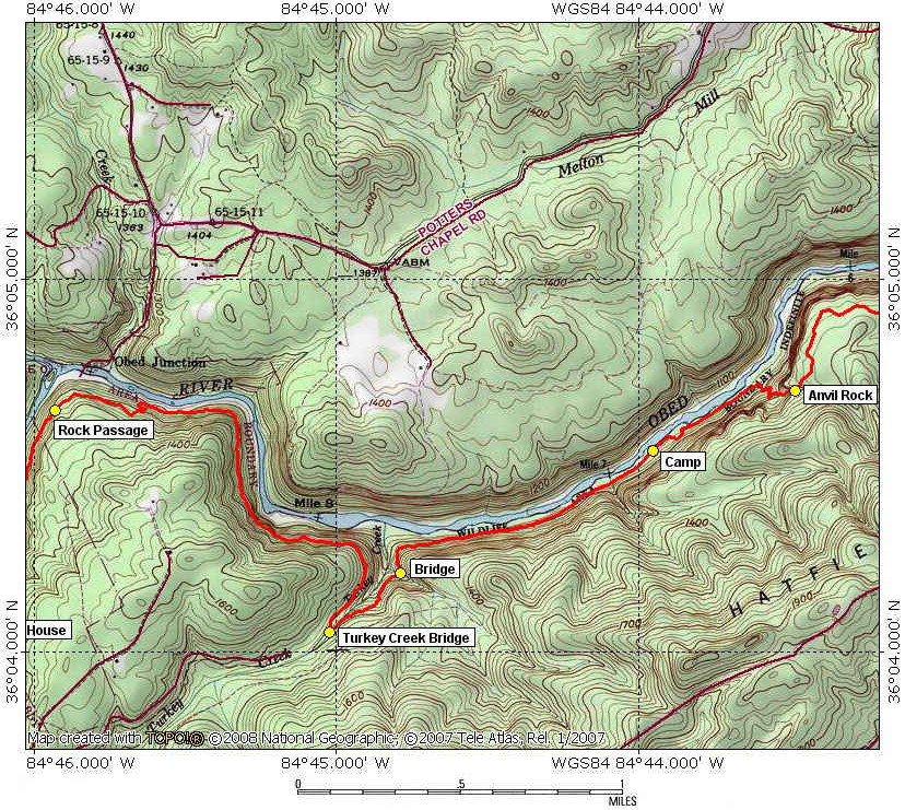
Mile 3.2 (10.9) Descend a rocky talus slope as the trail makes a couple of switchback turns. Pay attention to these turns since they may be easy to miss as you watch your step. At the bottom, turn right on an old railroad bed. In the early 1900s, this was a section of the Morgan & Fentress Railroad that ran 23 miles from Nemo to Obed Junction, which is located at the intersection of Daddys Creek and the Obed River. There were many temporary spurs off the main line that carried coal and lumber as these resources of the area were exploited. Now the railbed is overgrown with small hemlocks and small trenches where the rail ties use to be.
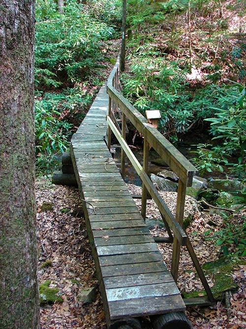
Mile 3.7 (10.4) The trail dips off the railroad bed, crosses a stream, then returns onto railbed. Notice the rock foundations that once supported a railroad bridge crossing of the stream.
Mile 4.1 (10.0) Trail narrows as it passes through a rockslide on the railbed. These rockslides were not uncommon, but when the rail line was operating, they were quickly cleared so the coal and lumber could get through.
Mile 4.2 (9.9) A coal mine shaft is to the right. The narrow opening was just big enough for a small coal cart on tracks to get through. Men working these mines did not have room to stand straight; so they would kneel or bend down to work the mine.
Mile 4.3 (9.8) Cross a rock ledge with three metal pins protruding out of rock. The reason for these pins is unknown but presumably had something to do with the mining.
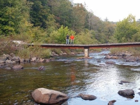
Mile 4.5 (9.6) Leave the railbed to the left and descend into Turkey Creek drainage. Cross the creek on the 45-foot-long Turkey Creek Bridge. A plaque on the bridge honors Janet Roe Parvin and Bret Edward Parvin. Tad and Diane Parvin are long-time active members of the Plateau Chapter of Tennessee Trails Association and Cumberland Trail Conference supporters who made a very generous memorial contribution in memory of Tad’s mother and brother. The contribution was part of the Cumberland Trail Conferences 2000 Capital Campaign to purchase the gorges of Rock, Possum, and Soddy Creeks in Hamilton County. As an incentive, donors could have a plaque placed on a bridge of their choosing. Many committed individuals such as Tad and Diane contributed to making such land purchases possible.
Rock steps go back up to another railroad bed; turn left. This railbed seems to have been a spur off the 23-mile Morgan Fentress Railroad.
Mile 4.7 (9.4) The trail intersects another railroad bed but stay straight. The trail leaves the railbed and descends rock steps on the left. Soon after another roadbed intersects the trail on the left, continue straight.
Mile 4.8 (9.3) Cross a 26-foot-long bridge over an unnamed branch of the Obed. The trail turns left back onto the railroad bed. The trail remains on the railbed for the next 1.4 miles. This was a section of a narrow-gauge extension of the Morgan and Fentress from Turkey Creek that extended eastward back into the Catoosa area to a point opposite the mouth of the Clear Fork River.
Mile 5.9 (8.2) The trail stays along the Obed River for the next quarter mile where there are nice beaches and swimming holes. This is one of the few places that has reliable water, but treat all water before drinking. As an exception, this area was used as a backcountry camping area for volunteers who were building this section of trail in 2000 and 2001; as a rule, backcountry camping is not allowed in the Catoosa WMA.
In the spring and summer, blue herons and belted kingfishers hunt for small fish and frogs along the river’s edge. Rarely, you may also get a glimpse of river otter and mink on the river banks or swimming in the pools of water, hunting for fish.
Mile 6.2 (7.9) Leave the railroad bed to the right and ascend through a rocky area. The trail makes “S” curves out of the Obed River Gorge to top of the plateau.
Mile 6.5 (7.6) At the top of the climb stands Anvil Rock on the right, a stacked rock formation appropriately named by CT volunteers. After crossing a small drainage, the trail begins to level off. A side trail on the left leads 120 ft to “Ohmygod” overlook. Take the right to continue on the CT through the upland hardwood forest.
Mile 7.1 (7.0) Descend to a small stream, then follow the trail climbing to the right.
Mile 7.2 (6.9) Cross an old roadbed and continue ascending.
Mile 7.4 (6.7) The trail joins a road used by All Terrain Vehicles (ATVs), which are allowed by permit in Catoosa WMA.
Mile 7.5 (6.6) Turn left into the woods.
Mile 7.8 (6.3) To the left, a short side trail leads to a view of the Obed River.
Mile 8.1 (6.0) Cross a small stream and ascend back onto road; go left. Stay on the road for the next mile.
Mile 8.7 (5.4) The trail crosses a drainage that is a large muddy area caused by ATVs and wild hog activity.
Mile 9.2 (4.9) Cross a small stream and continue on the road.
Mile 9.4 (4.7) After crossing another stream, the trail turns right at an old homeplace. During the years of logging, the Tennessee Mineral & Lumber Co. began leasing lands after the timber was removed and suitable for crops and livestock grazing. The area eventually became interspersed with many small farms, whose occupants made their living working part time in the forests and mines and by unrestricted grazing of livestock in the area. As a result of a flood that destroyed the bridge at Nemo, and also the Great Depression, mining and lumbering operations were suspended. The residents who remained in the area became dependent upon open grazing of their livestock for a living. To improve grass production, frequent fires were set and often raged unchecked across the land. With the passage of the “fence law” by the Tennessee legislature in 1947, however, open grazing was abolished and soon the majority of these small farms were abandoned.
Mile 9.7 (4.4) Dip through where another ATV road intersects the trail; follow the trail to the left for 0.1 mile, then turn right into woods, leaving the road.
Mile 9.9 (4.2) A side trail on the left leads 50 ft to BreakAway Bluff. This iconic bluff is what the Cumberland Trail is all about. Named by volunteers during the first Spring BreakAway™ Program that worked on this section of trail in 1998, BreakAway Bluff looks down into the gorge of the Obed
The topography of the area is characterized by a dendritic drainage pattern and narrow, V-shaped gorges with many sheer bluffs at the gorge rim towering over wooded talus slopes. The river valleys are dotted with huge boulders that have broken from the cliff faces.
Mile 10.1 (4.0) Turn left onto a roadbed; proceed 250 ft to turn left off the road. The trail climbs up and down through rock talus fields for the next mile.
Mile 10.3 (3.8) Turn left onto an old roadbed, and descend 110 ft to turn right off the road. Continue descending to the Obed River.
Mile 10.4 (3.7) The Obed River is on the left with a beach area and easy access to water. The trail climbs through a talus field to cross a drainage.
Mile 10.9 (3.2) Leave the rocky area and begin to descend on gradual switchbacks.
Mile 11.4 (2.7) A homemade “No Camping” sign reminds hikers that no camping is allowed. The trail goes through house-size sandstone boulders.
Mile 11.7 (2.4) Reach the trail intersection leading to Alley Ford. This is also the boundary of Catoosa WMA managed by TWRA as the CT enters the corridor of the Obed Wild and Scenic River managed by the National Park Service. Turn left to take an eroded roadbed 0.2 mile to Alley Ford. The road ends at a sandy beach area that has room for many tents.
Mile 11.8 (2.3) Cross a footbridge over a stream and begin ascending to a strip mine.
Mile 12.1 (2.0) Reach top of a berm from the strip mine and cross a small footbridge over mine drainage. The trail continues on the strip mine berm with the high wall on the right. Strip mining occurred in the area during the ‘50s and ‘60s. It was a less costly process of extracting coal than the traditional coal mine. Miners used large machinery to first remove soil and rock (which you are hiking on) to expose the coal seam. They would then scoop up the coal, load it on trucks, and transport it out of the area. As you continue on the trail you can see how the strip follows the contour of the mountain. This process is much more destructive than the shaft mining technique, but requires fewer workers and mines more coal.
Mile 12.3 (1.8) The trail leaves the berm onto a road after crossing the small footbridge over mine drainage.
Mile 12.4 (1.7) Leave the road on the left to go around a slide area. Pick up the road again after 300 ft.
Mile 13.0 (1.1) Trail leaves the road on left.
Mile 13.3 (0.8) Pass a rock shelter.
Mile 13.5 (0.6) Cross a footbridge over a drainage.
Mile 13.7 (0.4) Arrive at a junction with the Emory River Nature Trail. The loop nature trail is 0.7 mile and on one side shares the CT into Rock Creek Campground. The nature trail leaves the CT at this point to the left and loops down to the Emory River where will come out at Rock Creek Campground. To stay on the CT, continue straight; another rock shelter is just past the nature trail turnoff.
Mile 14.1 (0.0) Enter Rock Creek Campground at a trail mileage sign. For camping, reservations must be made through recreation.gov
The campsites are first-come, first-served, with 11 spaces available. There are no amenities other than vault toilets. At the paved road, turn right 120 ft to Nemo Trailhead parking and information kiosk.
The Obed River Section ends here at Rock Creek Campground but also may be accessed at the Nemo Picnic Area and River Access area on the other side of the river. To continue, turn left when you reach the parking area and kiosk and follow the paved road to exit the campground. At top of the hill, walk straight to the old highway bridge, replaced by a new adjacent bridge. The old Nemo Bridge, built around 1930, was converted to a pedestrian footbridge when the new bridge replaced it in 1999. After crossing Nemo Bridge, pass a trail kiosk, and turn left into Nemo Access in 0.3 mile from the campground.
—Mark Stanfill, State Parks Trails Administrator, Cumberland Trail State Scenic Trail; CT Trail Volunteer & Wagon Master and former CTC Programs & Volunteer Coordinator
More Information
Obed River Topo Maps
The following detailed topographic maps of the trail were created using TOPO! 2009 National Geographic found at National Geographic Topo Explorer.
GPS Waypoints
| Location | GPS Waypoint in WGS 84 format |
|---|---|
| Piney River Trailhead | N35 42.834 W84 52.821 |
| McDonald Creek | N35 42.091 W84 53.617 |
| Piney River Bridge | N35 42.219 W84 54.313 |
| Pine Branch Bridge | N35 41.980 W84 54.596 |
| Rockhouse Branch Bridge | N35 41.665 W84 54.800 |
| Logging Camp Loop Spur | N35 41.643 W84 54.758 |
| Rockhouse Branch Spur | N35 41.522 W84 54.784 |
| Hemlock Falls Spur | N35 41.488 W84 55.220 |
| Deep Pool Bridge | N35 41.574 W84 55.353 |
| Spider Den Spur | N35 41.422 W84 55.657 |
| White Pine Cascades | N35 41.218 W84 56.033 |
| Duskin Creek Bridge | N35 41.434 W84 56.797 |
| Duskin Creek Parking | N35 41.402 W84 56.997 |
| Newby Branch Trailhead | N35 42.076 W84 57.285 |
Catoosa WMA
2016-2017 Update: According to the 2016-2017 TWRA Hunting Guide, Catoosa is now open year-round for thru hiking on the Cumberland Trail. This is a significant change from previous policy. However, until the section from Devil’s Breakfast Table to Peavine Road is complete, real thru hiking will not be available. During big game hunting you cannot drive into DBT trail head.
Hikers must wear florescent clothing to maintain visibility to hunters in the area during hunting seasons. See details HERE and (page 56) at bottom of this article.
For more information concerning hiking in Catoosa WMA contact the TWRA Region III area office at (931) 484-9571 or 1-800-262-6704 from within Tennessee.
Catoosa Wildlife Management Area was established in the early 1940s when the Crossville Exchange Club appointed a commission to encourage the state of Tennessee to purchase a large tract of land for a wildlife management area. In 1942, the Conservation Commission made the initial purchase of 63,000 acres from Tennessee Mineral & Lumber Company. That original tract was bought with Pittman-Robertson federal aid funds as a wildlife restoration project and was mandated for wildlife conservation. The Pittman-Robertson funds came from federal taxes on sporting equipment. In 1949, the Tennessee Game and Fish Commission, now Tennessee Wildlife Resources Agency, established a tentative purchase boundary that encompassed approximately 90,000 acres. A land acquisition program was initiated at that time to eliminate interior holdings, which continues to this day.
By the early 1900s, most wildlife species in the Catoosa area were nearly wiped out. Restocking of deer began in 1942 on the initial acreage with the purchase and then release of 324 deer for $100 each from Wisconsin. The deer population grew enough for managed hunts to begin in 1952. In recent years, turkey have increased in number and black bears are making their way south from the Big South Fork. It is in the upland forest where you may come across this big game. Unfortunately, an increase in the non-native wild boar has caused many problems. With no natural predators and multiple breeding periods, boar numbers have exploded. In some areas along the trail, the hiker can see evidence of their rooting, which destroys native plants and damages the trail.
The CT is open year-round in the corridor of the national river from Alley Ford to Nemo Bridge.
As of 2016 hunting season the CT through CWMA is open for thru hiking year-round. However, please observe the general hunting schedule shown here. During these periods hikers must wear florescent clothing to maintain visibility to hunter in the area. Details HERE. See page 56.
In general, hunting dates follow this schedule:
Mid-October through December various long weekends (Fri – Sun)
February and March for all users (roads are gated, not allowing motorized vehicles)
April to first week of May, on most days.
For specific hunting periods in Catoosa, contact the Region III WMA Office at 1-800-262-6704. —MS
For more information concerning the TWRA Region III area, please call (931) 484-9571 or 1-800-262-6704 if calling from within the state of Tennessee.
Nemo
The town of Nemo was located where Island Creek joins the Emory River just downstream from Nemo Bridge. This is also the location where the old Catoosa Railroad line passed.
The railroad bridge was damaged by the flood of 1929 and finally destroyed by the flood of 1940. Following the latter flood, the bridge was never rebuilt and led to the town of Nemo’s decline.
“Nemo” is Latin for “no one.” The name was used for convenience more than anything else; stops along the rail line were to be kept in alphabetical order, and Nemo served as the stop after Montgomery and before Oakdale. The nearby town of Lancing on the rail line was formerly known as Kismet, but its name was changed in order to keep the alphabetical sequence intact.
— MS