Emory River Gorge
Obed/Emory Confluence to Nemo Bridge
Overview
This section of the Cumberland Trail will eventually climb from Emory River Gorge within the National Park Service (NPS)-administered Obed Wild and Scenic River (WSR) to the edge of the Cumberland Mountains in the town of Wartburg. Emory River Gorge marks the place where the current version of the Cumberland Trail departs from the trail’s original route.
Although only 1.3 miles of the CT have been constructed in this section to date, entirely within the Obed WSR, the section contains several gems. The iron bridge over the Emory River is a piece of history saved only by the efforts of those with a long-term vision for the CT. The railroad tunnel overlook near the section’s north end is one of the most unique along the trail.
Trail Section Details
Features:
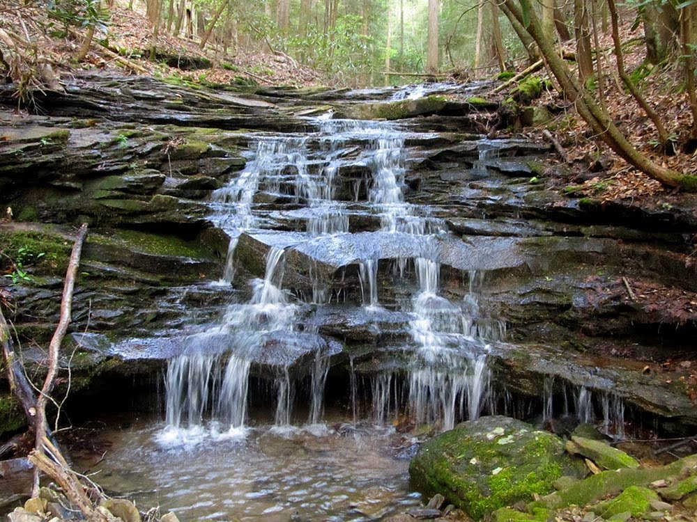
- Waterfalls
- Swimming
- Wildflowers
- Fall color
Counties:
- Morgan
Distance:
1.3 miles
Difficulty:
Easy
Elevation Change:
450 feet gain and loss
Northern Terminus:
(N36 04.135 W84 39.674)
Southern Terminus:
Obed WSR Rock Creek Campground (N36 04.242 W84 39.880) or Obed WSR Nemo
Timezone:
EDT
Cautions:
No access on the northern end of completed section.
Camping:
Rock Creek Campground of the Obed Wild and Scenic River is located at the southern trailhead. The primitive campground has 12 sites and pit toilets, but no water or electric hookups. Water is available from the river or side streams but must be treated.
Topographic Maps:
Camp Austin and Lancing Quadrangles
Trailheads
From the junction of TN 62 and US 27 at the southern end of Wartburg, drive north on the combined highways for 0.6 mile and turn left on Kingston Street at a sign for the Obed WSR. After one block, turn right on Eliza Street; then after another block, turn left onto Maiden Street. The Obed WSR Visitor Center is on the right in the first block at 0.7 mile (N36 06.424 W84 35.889).
From the visitor center, continue south on Maiden Street for two blocks, then turn right on Spring Street at 0.2 mile. On the west end of Wartburg, at 0.5 mile, Spring Street turns sharply left and becomes Catoosa Road. Follow this narrow, winding, paved road to the entry to the Obed WSR Nemo Picnic Area at 5.8 miles, just before Nemo Bridge.
You can start your hike here at the Nemo Picnic Area but also from the Obed WSR Rock Creek Campground. To reach that access, cross the Emory River on the new concrete bridge. At 6.1 miles, turn right onto the gravel entry road for the Rock Creek Campground. Trailhead parking for the CT is located at the campground registration area at 6.2 miles. There are pit toilets in the campground. The CT Nemo Trailhead is 100 feet farther down the campground road.
The northern end of this section, when constructed, will be at the new Morgan County Visitor Center in Wartburg at the TN 62/US 27 junction. Approximately 5 miles of new trail will eventually head northeast from the current trail end and pass through Wartburg to the visitor center. Route yet to be determined.
Description
Mile 0.0 (1.3) Begin by following the gravel access road from the Rock Creek Campground back to Catoosa Road.
Mile 0.1 (1.2) Turn left onto the paved Catoosa Road.
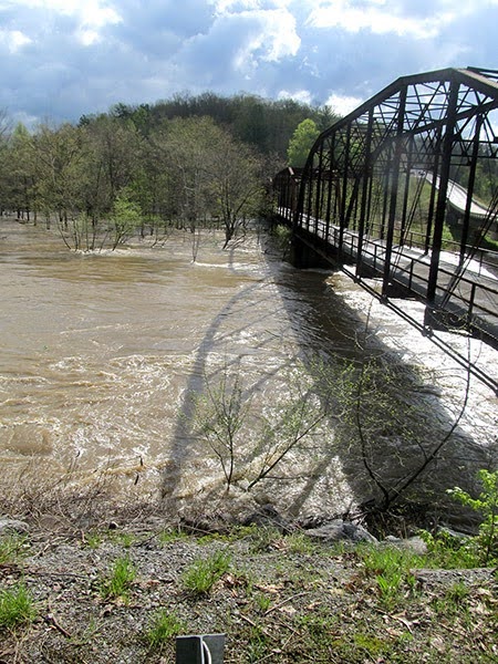
Mile 0.2 (1.1) Turn left off the paved road and cross Emory River on the historic iron Nemo Bridge. The 480-foot-long Camelback Truss Bridge was built around 1930 by the Atlantic Bridge Company after a great flood earlier that year destroyed an older bridge. By the late 1990s, the iron bridge was scheduled to be replaced and was nearly destroyed after the new Nemo Bridge was built. However, the historic bridge was saved for CT hikers in 2000 by an agreement between the CTC, Morgan County, and Tennessee State Parks with support from TDEC and TDOT.
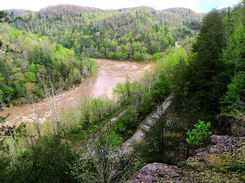
Mile 0.3 (1.0) Reach the Obed WSR Nemo Picnic Area and River Access. This area is frequently used as river access for the Obed and Emory rivers by paddlers. Both this picnic area and the Rock Creek Campground are well within the flood plain of the Emory River and are subject to flooding after heavy rains. The CT leaves the picnic area on the upstream end of the area along an old road.
Mile 0.4 (0.9) Turn right off the old road and begin climbing on a narrow trail.
Mile 0.5 (0.8) Cross a well-used dirt road. Just beyond this crossing is a series of wooden steps constructed in 2007 by Eagle Scout Stuart Fried. At the top of the steps, turn left and follow an old road cut upriver.
Mile 1.0 (0.3) Turn right again and climb another set of switchbacks to a shelf at the base of a line of cliffs. Follow the shelf upriver.
Mile 1.2 (0.1) Reach a stunning overlook above the Emory River. This overlook resulted from construction of a Norfolk Southern railroad tunnel, the mouth of which is just below the overlook. Blasting for the mouth of the tunnel leaves the hiker with an exceptional view of the Obed at its confluence with the Emory River. The exit of another railroad tunnel is visible to the north, farther up the Emory River Gorge along this active line. Be very careful while exploring this overlook; the walls of the cliffs below are vertical.
Mile 1.3 (0.0) The current end of this section is at a sign located at a dilapidated bridge over a small cascading stream, just before the confluence of the Obed and Emory. There is no access here, so hikers must retrace their route back to the trailhead.
The CTC estimates that another 5.0 miles of trail will be needed to extend the trail beyond the confluence of the Obed and Emory rivers, across the boundary of the Obed WSR, and into the town of Wartburg.
−Hiram Rogers, FHSP Volunteer Trail Crew Member and CTC Board Member
More Information
Original Route
When first conceived, the Cumberland Trail was expected to turn south from the Obed River and run through the Lone Mountain State Forest. From Lone Mountain, it would have followed a 21-mile section along Whetstone Mountain and then Walden Ridge into the town of Oliver Springs. From Oliver Springs, the trail followed Walden Ridge northeast through Lake City into Caryville, where it joins the current route of the CT.
Although much of the older route was constructed, these sections fell into disrepair after the State of Tennessee pulled support from the Cumberland Trail in the 1980s. Much of this land was privately owned when the CT was first built, and much is now held by the Coal Creek Company, which operates its holdings as a pay-for-play recreation area that caters primarily to ATV riders.
With the acquisition of the lands that are now part of the North Cumberland Wildlife Management Area, the opportunity to use a huge new area of public land and the opportunity for the Cumberland Trail to visit the Cumberland Mountains threw support to the trail’s current route. −HR
Paddling the Obed Wild and Scenic River
Although this is a web guide written by hikers for hikers, the best way to explore the Obed isn’t necessarily on foot.
Along with the tributaries of Daddy’s Creek and Clear Creek, the Obed River Wild and Scenic River (WSR) contains around 45 miles of the most scenic and challenging whitewater paddling in the Southeast and is known for near-continuous technical paddling.
Depending on water levels, most of the runs in the WSR are Class II or III, with some runs rated class IV. The creeks and rivers in the WSR should only be attempted by experienced whitewater paddlers. December to April is the only time of year when river levels are consistently high enough for paddling. −HR