North Chickamauga Creek
Montlake Rd to Barker Camp Rd

Overview
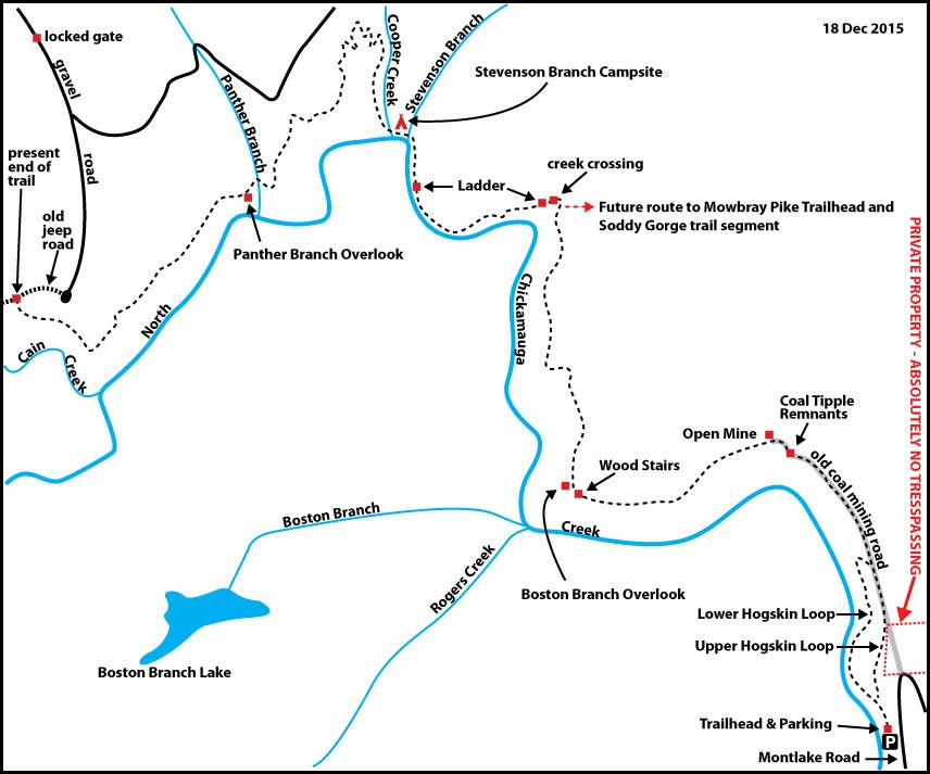
The Great Eastern Trail (GET) will arrive from the south at the Montlake Road Trailhead after passing through Chattanooga. The GET will then use the first portion of this trail to Mile 3.1 where a potential routing of the CT will head northeast. From the Montlake Road Trailhead, Upper and Lower Loop Trails soon merge on top of the escarpment. The hiker will then encounter converted mining roads that make for easy walking; coal mining dominated this area at one time. A rugged descent then drops back into North Chickamauga Creek Gorge to form Stevenson Branch into the Stevenson Branch campsite.
Leaving the campsite, the trail fords Cooper Creek just upstream of its confluence with North Chickamauga Creek and then climbs out of Cooper Creek Gorge. Headed west, you’ll pass along the forested slope above the escarpment. After crossing Panther Branch, the trail emerges from encompassing forest to intermittently enter and exit an adjacent second-growth mixed deciduous hardwood forest while skirting the edge of a clearcut (estimated to have occurred around 2005). Near the end of the hike, the trail intersects an old dirt road where the CT, when constructed, will continue southwest.
Highlights of the State Natural Area Section include stunning overlooks of Panther Branch and North Chickamauga Creek Gorges, as well as the exceptional Stevenson Branch campsite adjacent to waterfalls, rapids, and interesting rock formations—one of the most picturesque campsites of the entire Cumberland Trail.
Trail Section Details
Features:
- Waterfalls
- Overlooks
- Swimming
- Wildflowers
- Bluffs
Counties:
- Hamilton
Distance:
8.3 miles
Difficulty:
Strenuous
Elevation Change:
500 feet loss and gain (2x)
Northern Terminus:
Barker Camp Road Trailhead (N35 16.308, W85 17.116)
Southern Terminus:
Montlake Road Trailhead (N35 14.254, W85 14.066)
Timezone:
EDT
Cautions:
Creek ford, rugged ascent and ladder, steep slopes
Camping:
Stevenson Branch Campsite at mile 4.1 (4.2)
Seasonal Notes:
Slick sections when experiencing rainfall
Water Sources:
Very reliable
Trailheads
On US 27 north of Chattanooga, take the Thrasher Pike exit, turn northwest (left off exit ramp if heading north) and proceed 0.5 mile to the traffic light at Dayton Pike. Turn right, proceed 0.6 mile to Montlake Road, and turn left to begin an ascent of Mowbray Mountain. In 1.2 miles, turn left into the Montlake Road Trailhead. This parking area is closed at 7pm, so day hikers should plan to leave and overnight backpackers to arrive before that time; the area reopens at sunrise.
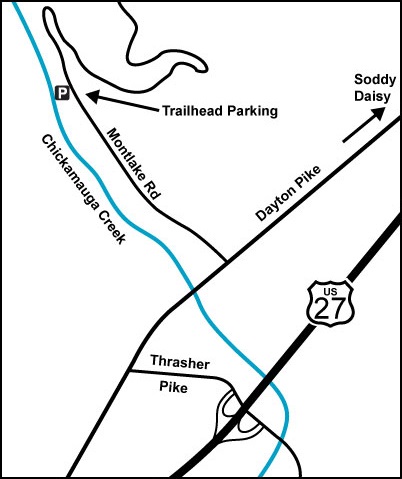
To get to the Barker Camp Road Trailhead, pass the Montlake Road Trailhead and continue on Montlake Road for another 3.5 miles and turn left on Poe Road. Stay on Poe Road for 6.2 miles and take a left on Grant Road (careful, it sneaks up on you). Travel 0.2 mile and take a left on Barker Camp Road. Continue for 3.9 miles (stay left at the Y-intersection with Walnut Grove Road) until you reach a gate across the road. (Note: The last 0.7 mile of Barker Camp Road is gravel.) You may park here but do not block the gate or road. Overnight parking is permitted but discouraged due to reports of break-ins; remove all valuables from your vehicle.
Map
Description
This description runs north to south.
Mile 0.0 (8.3) From the Montlake Road Trailhead parking and kiosk, the trail follows an old mining road headed north.
Mile 0.1 (8.2) Reach the Hogskin Loop junction. For the shortest route, bear right on the Upper Loop Trail. The 0.7-mile Lower Loop Trail stays on the old road that eventually fades into a path following North Chickamauga Creek upstream past picnic tables and numerous blue holes that offer swimming possibilities in summer. The Lower Loop crosses Hogskin Branch and makes a steep ascent to connect with the Upper Loop Trail on top of the escarpment.
Mile 0.4 (7.9) The Hogskin Upper Loop Trail ascends the escarpment to reach an old mining road on top. Turn left. (The old road to the right leads out to Montlake Road but is private property, absolutely no trespassing.)
The Upper Loop follows the mining road to cross Hogskin Branch while paralleling the Lower Loop below.
Mile 0.6 (7.7) Reach the junction with the Lower Loop Trail; this junction is easy to miss so you’ll need to watch for it. The Upper and Lower Trails offer a 1.4-mile loop from the trailhead if you’re out for just a short walk. After the junction, the trail was originally called the Stevenson Branch Trail all the way to the campsite on Stevenson Branch.
Mile 1.1 (7.2) The trail passes though the foundations of an old coal tipple. The coal was hauled to this point, separated by size in the tipple, and then transported out of the area.
Mile 1.2 (7.1) Make a steep ascent to an abandoned coalmine in the face of a higher escarpment. The mine is not very deep, only about 35 feet. It may have been the beginning of a mine that was subsequently terminated. Entry into any mine can be dangerous and, at present, is prohibited due to white nose syndrome that is decimating bat populations in the eastern U.S.
The trail follows the base of this impressive escarpment with numerous ups and downs. Notice the fascinating surface of mudpots—horizontal round basins in the rock outcropping that may have been formed by dripping springs from the top of the escarpment.
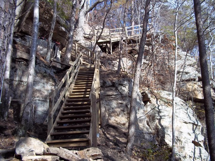
Mile 1.9 (6.4) The trail presses through a “fat man squeeze” and then ascends the escarpment via a remarkable stairway construction that combines ramps, risers, and rocks, reconstructed by the CTC in 2011.
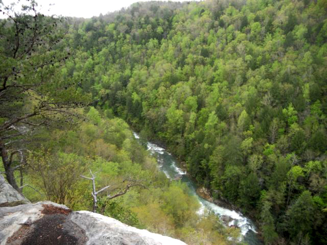
Mile 2.0 (6.3) Reach Boston Branch Overlook, perhaps the best overlook of North Chickamauga Gorge. To the east is the Soddy-Daisy area and to the south are the North Chickamauga Creek tributaries. The results of recent wildfires can be seen but will disappear as the forest rejuvenates. Vultures ride warm air currents sweeping up from the gorge.
Mile 2.5 (5.8) A short ascent reaches an old mining road that passes a concrete paved area previously used for mining equipment operations. This area was built from slag removed to access coal in the mines that once opened in the bluff. The contrast between the steep ascent and now the virtually flat bench/road is worth a water break.
Mile 3.05 (5.25) The trail travels along the old strip mine bench, sometimes mining road before turning left off the road. The turn can be easily missed, so previous hikers have left behind a large rock cairn to mark the turn.
Current plans call for the CT coming from the west to turn northeast here, leaving the current trail to make a connection with an existing trailhead on Mowbray Pike that is the southern terminus of the Three Gorges Segment. The exact route has not yet been determined, but potentially a new trail will be constructed from this point a couple of miles out to Poe Road. Thru-hikers would then walk Poe Road to the right, then Montlake Road and Mowbray Pike (a 3.2-mile roadwalk) to the existing trailhead on Mowbray Pike in order to continue north on the CT. The GET, which has been following the CT to this point, will also turn northeast here to continue with the CT. The portion of trail you’ve just hiked, from the rock cairn back to the Montlake Road Trailhead, will become a side trail off the CT when the new CT route is constructed.
To continue on the existing trail, turn left off the old strip mine bench/road, following the route of the CT.
Mile 3.1 (5.2) Reach a creek crossing on a flat slippery stone base. A cable once aided in crossing but is now broken. Plans are to re-route the trail here a short distance upstream (perhaps 50 feet) and not repair the cable. Meanwhile, hikers should not try to cross the creek where the cable was (that crossing is on the brink of a dropoff) but rather find a safer route upstream.
Approximately 110 feet after the crossing, you’ll descend a ladder beside a wet-weather runoff and continue down to the base of the escarpment.
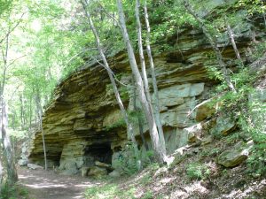
Mile 3.2 (5.1) At the base you’ll see a horizontal fault in the escarpment between the crab orchard sandstone above and iron ores below. The trail then passes a series of very large rockhouses under which the trail meanders. The largest rockhouse is over 400 feet long and 60 feet deep, and one can imagine the Indians and explorers that have set foot and perhaps camped here under the overhangs.
The descent from the escarpment is very rugged; care should be taken to locate and follow the white blazes marking the trail; previous wrong turns by hikers have created trails that are more pronounced than the real trail.
Mile 3.8 (4.5) Take care at the crossing of a wet-weather runoff; the moss-covered rock is slippery even in dry weather. Then climb down a short ladder without handrails and descend to Stevenson Branch where the CT crosses into the Stevenson Branch Campsite.
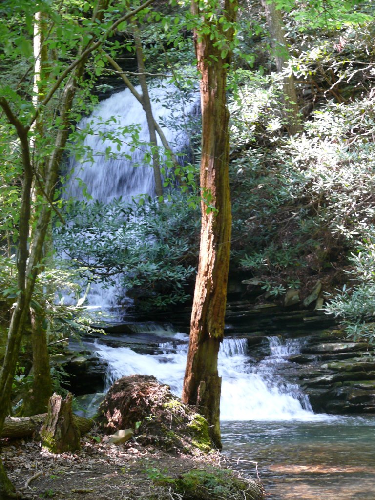
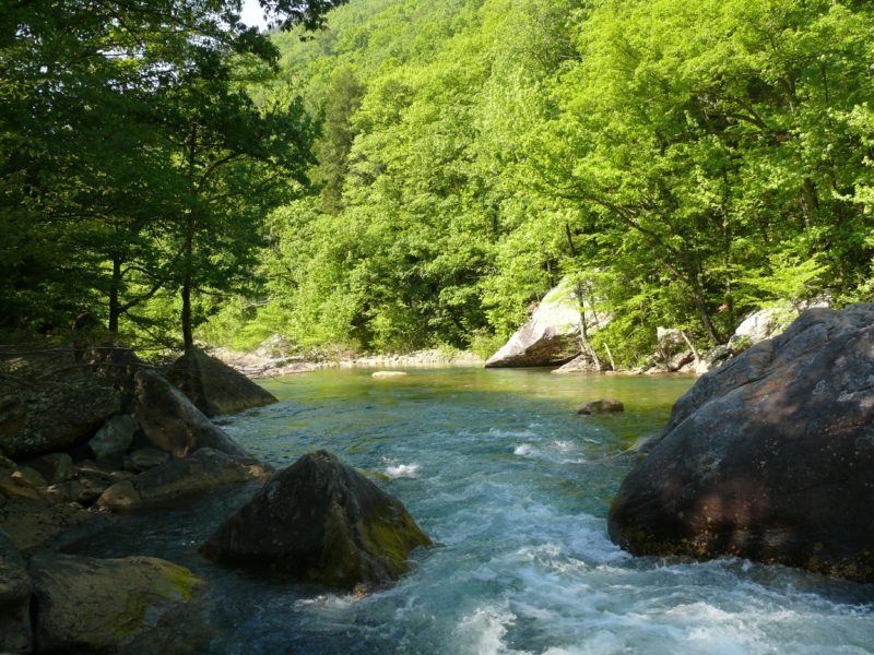
Stevenson Branch Campsite is exceptional, nestled at the base of a vertical sandstone wall to the north, with Cooper Creek 200 feet to the west, North Chickamauga Creek 100 feet via unmarked footpaths to the south with endless swimming opportunities, and Stevenson Branch less than 50 feet away to the east, displaying a waterfall and an inviting plunge pool.
Mile 4.1 (4.2) To continue on the CT, stay straight ahead to ford Cooper Creek. Use extreme caution crossing Cooper Creek, especially during periods of rain and high-flow conditions.
(This piece of CT continuing west from the campsite was constructed by students in the 2011 Spring BreakAway™ Program.) The trail parallels Cooper Creek upstream, offering great views of rapids, waterfalls, and plunge pools, all surrounded by massive boulders, rock walls, and towering Eastern hemlocks, which as elsewhere are threatened by the hemlock wooly adelgid. In spring, watch for flowering red buckeye trees, red trillium, foamflower, and the blooms of many other wildflowers and trees.
Mile 4.7 (3.6) Complete the ascent out of Cooper Creek Gorge to top the escarpment. Cross two small unnamed tributaries of North Chickamauga Creek.
Mile 5.7 (2.6) The trail reaches Panther Branch. No bridge currently exists at this location, so use caution while fording the branch during periods of rain.
Mile 5.8 (2.5) A spur trail to Panther Branch Overlook is on your left (right), just signed “Overlook.” This side trail, 175 feet in length, is marked by yellow blazes. The view from this overlook is spectacular, with upstream and downstream views of the impressive North Chickamauga Creek Gorge and the sound of nearby Panther Branch plunging off the escarpment during periods of rain.
Mile 6.0 (2.3) Another view of North Chickamauga Creek Gorge is on the left. About 300 feet beyond is an unofficial path that leads to a rock outcropping on a slope; do not go this way, it’s dangerous and you’ve already had the best views.
Mile 6.5 (1.8) The trail crosses a small unnamed tributary of North Chickamauga Creek and a second small unnamed tributary in another 0.2 mile.
Mile 7.0 (1.3) The CT then meandering through a mixed-deciduous hardwood (oak-hickory) forest interspersed with American holly, as well as mesophytic species such as Eastern hemlock and mountain laurel. The trail occasionally exits the forest to skirt the edge of the former clearcut on the right, now dominated by young pine trees, with the forested slope above the Cain and North Chickamauga Creek Gorges on your left. In a few years, the clearcut may not be so obvious.
Mile 7.2 (1.1) The trail emerges from the forest at the edge of the clear cut and soon intersects with an old jeep road. This is the current end for the North Chickamauga Creek Segment of the CT. Turn right on the old road, leaving the Cumberland Trail.
Mile 7.4 (0.9) The jeep road ascends to an old gravel parking lot. Bear left on the road leading out of the old parking. Bear left at both forks in the road to continue up Barker Camp Road.
Mile 8.3 (0.0) Reach the gate and parking for the Barker Camp Road Trailhead.
Description provided by Gary Keckley, CTC Volunteer & Tom Becktold, Local Outdoor Enthusiast
More Information
NOTE: Canyon Rim Drive, a private road, is not to be used to enter or exit Cumberland Trail.
Waypoint Coordinates
| Location | Waypoint in WGS84 Format |
|---|---|
| Trailhead | N35 14.254 W85 14.066 |
| Coal Tipple | N35 15.101 W85 14.426 |
| Mine Shaft | N35 15.135 W85 14.504 |
| Boston Branch Overlook | N35 15.002 W85 15.235 |
| Ladder #1 | N35 15.855 W85 15.292 |
| Ladder #2 | N35 15.883 W85 15.783 |
| Stevenson Branch Campsite | N35 16.071 W85 15.862 |
| Spur to Panther Branch Overlook | N35 15.865 W85 16.393 |
| Temporary end of trail | N35 15.552 W85 17.211 |