Lawson Mountain
Norma Road to Smoky Creek Road
Overview
Hikers should indeed feel they are in the “Heart of the Cumberlands” while walking the Lawson Mountain Trail—and will give their own hearts a good workout on the many ups and downs.
From its southern terminus at the Cave Branch Trailhead on Smoky Creek Road, the trail heads up Cave Branch then climbs about 1,300 feet to a rocky ridge that divides two watersheds. After a pleasant ridgetop stroll, the trail descends 750 feet to Bowling Branch, where two small ponds show old evidence of beaver.
After a short walk through healthy stands of laurel, walking fern, and ground cedar, the trail ascends 840 feet in less than a mile to Lawson Mountain’s summit ridge. After a mile walk along an old road used by 4-wheelers and ATVers, primarily on weekends, the trail steeply, then more gradually, descends 1,200 feet through the Lick Creek watershed to New River and the Norma Road Trailhead.
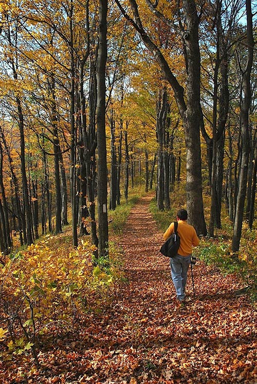
Trail highlights include an extensive hardwood forest that provides spring and summer serenades by many canopy-dwelling birds, great fall colors, tumbling mountain streams (in season), interesting rock formations, spring and summer wildflowers, far-reaching views at several points, and the possibility of elk sightings. You will also traverse a few areas that are recovering from coal strip mining years ago and may see evidence of current timbering near the trail corridor. The forest will eventually reclaim the newly cut areas as it has for more than a century.
Trail Section Details
Features:
- Overlooks
- Wildflowers
- Fall color
Counties:
- Scott
Distance:
9.8 miles
Difficulty:
Strenuous
Elevation Change:
1,350 feet
Northern Terminus:
Norma Road adjacent to the New River (N 36 18.211 W 84 23.147)
Southern Terminus:
Cave Branch Trailhead at Smoky Creek Road (N 36 13.260 W 84 23.142)
Timezone:
EDT
Cautions:
Frequent elevation gains and losses; several creek crossings could be difficult in high water
Camping:
No developed campsites, but several areas suitable for leave-no-trace backcountry camping; year-round water available in Cave Branch, Lick Creek, and New River but must be treated
Topographic Maps:
Norma and Fork Mountain Quadrangles
Trailheads
Access to both the Cave Branch and Norma Road Trailheads is off Norma Road in a sparsely populated area of Scott County. To reach them from I-75, take Exit 141, State 63, and go west towards Huntsville for 11.2 miles to left-turning Norma Road. It’s signed and is directly across from a closed service station. If coming from the west, turn off US 27 onto State 63 and go 9.2 miles to right-turning Norma Road. Follow Norma Road 7.8 miles south through the historic community of Norma to the Norma Road Trailhead on the right, the northern terminus for the Lawson Mountain Section. Note the wooden steps and “Cumberland Trail” signs on both sides of the road; the Anderson/Cross Mountains Section begins on the left. Parking space for several vehicles is at the graveled pull-off area with kiosk on the west side of the road just before the trailheads.
To reach the southern terminus at the Cave Branch Trailhead, continue from the Norma Road Trailhead for another 2.3 miles to Hembree’s Store on the right at Smoky Junction. Turn right immediately past the store onto Smoky Creek Road, which may not be marked. Cross a bridge over New River and follow Smoky Creek Road 4.8 miles from the store to the Cave Branch Trailhead on the right. A gravel parking area just past the trailhead along Cave Branch will hold several vehicles. The trailhead for the Arch Mountain Section toward Frozen Head State Park is directly across Smoky Creek Road and across Smoky Creek that parallels the road. Total distance for a shuttle between the Norma Road and Cave Branch Trailheads is about 7 miles.
Alternative access to the Lawson Mountain Section is up old Bowling Town Road, foot traffic only as it has been gated off to vehicles, that would allow an approximately 4.5 mile hike to either trailhead. At 2.2 miles on Smoky Creek Road from Hembree’s Store turn right on Bowling Town Road (signed). It quickly becomes a grass track with a house on the right. Bear left and enter the woods. Go 0.5 mile up this occasionally steep and rough forest road, crossing Bowling Branch several times over concrete culverts until an open area is reached just before a deep, washed-out creek crossing. Walk up the road about 1.2 miles to an old pond with evidence of past beaver activity. Turn right off the road onto the CT heading for the Norma Road Trailhead, or continue up the road for another 0.3 mile and turn left off the road onto the CT heading for the Cave Branch Trailhead. Bowling Town Road might be difficult-to-impassable in winter or a wet spring.
CAUTION: Drive both Norma and Smoky Creek Roads with care. They are hilly, narrow, and winding and have both paved and unpaved segments, some rough. When traveling either road, you are likely to meet heavy logging trucks, even on weekends.
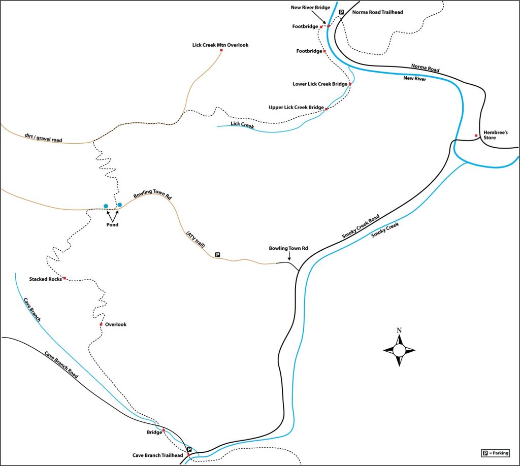
Map
Description
Mile 0.0 (9.8) At the Cave Branch Trailhead, head north up six rock stairs and quickly cross a deeply cut road created during recent timber harvesting. Today’s parking area was used as a staging/loading area as recently as 2011; the loggers agreed to establish the parking area when they were done. The trail winds slowly uphill, paralleling both Cave Branch and Cave Branch Road on the right. Elevation at the starting point is 1,300 feet.
Mile 0.1 (9.7) Cross several small drainages over the next 1,500 feet then descend toward Cave Branch. Note increasing tree species diversity, including shagbark and American hickory, umbrella magnolia, beech, and hemlock. Evidence of Hemlock Wooly Adelgid damage is now visible on many hemlocks along the trail, though none was seen several years ago.
Mile 0.35 (9.45) Cross Cave Branch over a wooden bridge and turn left onto Cave Branch Road, a gravel and dirt road.
Mile 0.4 (9.4) Turn right off the road. Continue above and roughly parallel to Cave Branch on your left, ascending and descending numerous times over the next half mile. Spring and summer flora along this stretch includes dwarf-crested iris, wild geranium, New York fern, and white bergamot. Log-staging areas are visible on the left in places.
Shortly before Mile 1.0, an ATV trail heads uphill on right – stay straight on trail.
Mile 1.0 (8.8) Descend a set of steps to road and go right, following road about 500 feet to another junction with the trail. Turn right off the road and begin ascending into an interesting area of artful trail building through large boulders and ravines, leaving all evidence of logging behind. Christmas ferns and little brown jug are prolific on this stretch.
Mile 1.5 (8.3) Just after crossing a small ATV road, trend right and begin walking along a small wet-weather stream on the left, noting small bluffs, seasonal cascades, and increasing hemlocks. A ten-step rock stairway marks the beginning of a long ascent.
Mile 1.7 (8.1) The trail turns right away from the stream, crosses an old logging road, and continues ascending, steeply in places.
Mile 2.0 (7.8) Before the 2-mile point, reach an overlook on the left of a deep ravine and seasonal waterfall. From here, the continuing climb out of the Cave Branch valley is moderate at first, providing opportunity to enjoy forest dominated by large maple, poplar, and beech, with occasional black gum and sassafras. Soon the grade steepens, and the trail proceeds up numerous switchbacks and curving turns.
Mile 2.2 (7.6) Reach an old logging track where the trail goes to the right up the hill.
Mile 2.4 (7.4) Shortly before this point cross an old ATV track.
Mile 2.5 (7.3) Finally, arrive at the southeast end of the ridge dividing Cave Branch and Bowling Branch for an elevation gain from the trailhead of about 1,280 feet. An old track goes both ways at this point—the trail bears left along it for a pleasant half-mile stroll along the ridgetop with little elevation change. Be sure to stay on the main trail when the old track diverges downhill to the right in a few hundred feet.
Mile 2.8 (7.0) Spring wildflowers in this area include mayapple, false Solomon’s seal, spotted mandarin, doll’s eyes, bloodroot, and wood anemone. Shortly ahead, intersect another ATV track that goes sharply downhill on right. Continue forward on trail along the ridgetop. Fall colors are particularly outstanding along the entire ridge.
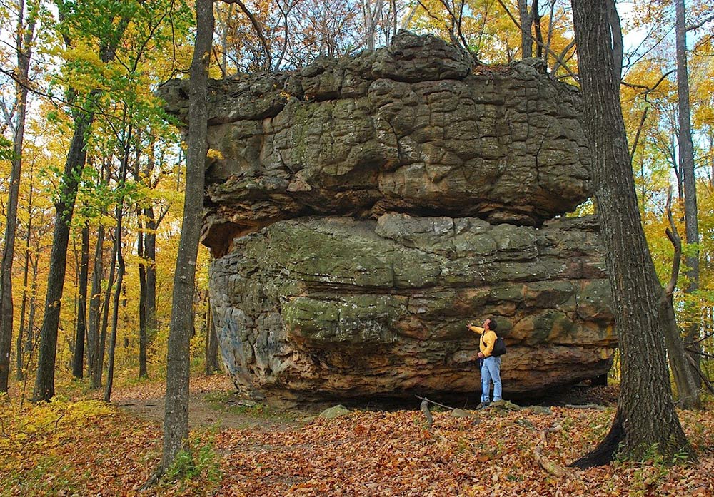
Mile 3.0 (6.8) Arrive at a massive ridgetop remnant of two stacked rocks at least 25 feet high. This would be a good Leave No Trace camping spot, though evidence remains of earlier campers. No water here. A few hundred feet ahead, another ATV track diverges downhill to the left. Continue forward along the ridgecrest trail.
Mile 3.2 (6.6) Walk below an interesting maze of rock outcrops along the ridge on your left.
Mile 3.3 (6.5) Reach the northwest end of the ridge and begin a moderate-to-steep descent on switchbacks toward Bowling Branch. Pass several large, isolated boulders that evidently tumbled from the ridge above. Take care in a few hundred feet to follow the trail sharply left on a switchback, avoiding the ATV track.
Mile 3.4 (6.4) The descent on switchbacks continues. Cross a small log bridge, encountering a seasonal creek that you’ll cross several more times on steppingstones. Also watch for another sharp left in the trail ahead, where another old ATV track goes right.
Mile 3.6 (6.2) Along this segment of the trail watch for cooler species of wildflowers and ferns in season on this northeast-facing slope, including wild ginger, jack-in-the-pulpit, and maidenhair, beech, and masses of New York ferns. Numerous large wild grape vines hang and twine in places.
Mile 4.0 (5.8) The grade levels as you approach a seasonal stream on the left. Proceed through a mixed forest of maple, poplar, and beech, crossing the stream several times. Several good camping spots can be found along this area. In places, scrubby undergrowth includes spicebush, sweetgum, and huckleberry. The trail heads northeastward and approaches a tributary of Bowling Branch on the right. Continue over nearly level trail through a pleasant forest of hemlocks and abundant mountain laurel. Large colonies of ground cedar are evident. Cross a small stream and reach a junction with dirt/gravel Bowling Town Road. (The Bowling Town coal mining community once existed nearby, in the 1910-1930s. Little evidence or written history can be found today.)
Mile 4.4 (5.4) Turn right onto the road and begin a gradual descent eastward. Pass a faint old road on the right and a pond with old beaver evidence on the left. Blackberries can be enjoyed in season along the roadway.
Mile 4.7 (5.1) Reach the trail turnoff just before another pond with old beaver signs. Turn left off the road at the tree-posted CT sign and metal marker, which may be partially obscured by plant growth in summer. Walk along the pond and through copses of mountain laurel. Pass prolific quantities of vine-like climbing fern, infrequent except in the Cumberlands. Begin a moderate ascent. After crossing an old logging road, begin a steep ascent via many switchbacks toward the crest of Lawson Mountain.
Mile 5.5 (4.3) The trail bears left, then right, and emerges into a sloping, overgrown field. Note the prolific common milkweed here in summer, typically considered a weed, but known by foragers as a tasty wild food source (first be sure to positively identify the plant, and do not eat if you’re not sure; although tender leaves and flower buds can be eaten raw, they are usually boiled or fried). Continue up the sometimes barely visible trail, built along old strip mine tailings.
Mile 5.6 (4.2) Reach a CT signpost at a junction with a dirt and gravel road. The elevation gain from the pond to this road junction is about 840 feet—pretty steep in less than a mile. Turn right on the road, which traverses Lawson Mountain. The entire ridgetop was stripmined for coal years ago. The reclaimed land now provides grassland for deer and possibly elk. Stripping has also caused heavy, invasive growth of Russian olive and honey locust. Follow occasional blazed posts along the road for a mile, enjoying the distant mountain views from late fall through spring. Many spots near the road are suitable for camping if you have adequate water with you.
Mile 6.5 (3.3) Shortly before reaching the next trail junction, a well-traveled ATV/4-wheel road turns right down the ridge. Stay left on the main road.
Mile 6.6 (3.2) Come to a well-signed, right-turn junction where the trail reenters the woods. (Sidetrip: You can continue on the main road past the trail junction for about 0.7 mile to an overlook on the side of Lick Creek Mountain. It offers an expansive view eastward over the New River valley and mountains beyond.)
On the CT, start a steep descent via a series of tight switchbacks. Continue down a sidehill trail through a pleasant hardwood forest with many chestnut oaks.
Mile 6.8 (3.0) Cross an old logging road near Lick Creek shortly after this point.
Mile 7.1 (2.7) The trail has descended about 560 feet in the last half mile from the road junction. Note the interesting rock shelter downslope on the left. Continue to descend moderately, crossing a small drainage and another old logging road. Continue down to a well-signed junction with a logging road.
Mile 7.4 (2.4) Turn right on the logging road and walk about 300 feet, bearing left toward Lick Creek when the road divides.
Mile 7.7 (2.1) Cross Lick Creek, go up rock steps to a signpost and cairn on the right. The pleasant stretch of trail ahead meanders near the left bank of Lick Creek for a half mile, crossing several drainages.
Mile 8.3 (1.5) Cross Lick Creek on high stepping stones, just above a 3-foot waterfall, and step up a wooden platform to regain the trail. A walking pole or strong stick would be helpful at the stepping stones in high water. The trail now follows along and above the right bank of Lick Creek, crossing several small drainages as it ascends along the slope.
Mile 8.5 (1.3) Shortly beyond this point, walk between two large beech trees. An even larger beech stands dead nearby above the trail on the right. (While beech wood was desirable for burning and for making wooden implements in earlier centuries, it is not useful to loggers, which is why many large beeches survive in our forests.) Soon the trail follows a series of switchbacks down to lower Lick Creek Bridge.
Mile 8.8 (1.0) Cross Lick Creek on the wooden bridge. The creek’s confluence with the New River is not far below on the right. Ascend past another large beech, crossing several old roads. You’ll begin to hear both Norma Road traffic and river sounds along this stretch, which parallels New River.
Mile 9.2 (0.6) Cross a footbridge over a ravine and later a small creek on a log bridge. Proceed downstream above and roughly parallel to a gravel road, losing elevation via three switchbacks. Reach the road and turn left. Follow the road down toward New River. In fall the roadsides are showy with yellow jewelweed, Joe Pye weed, purple asters, lobelia, and white snakeroot.
Mile 9.6 (0.2) Reach the road bridge over New River, a major tributary that flows into the Big South Fork National River and Recreation Area to the west. Elevation at the New River Bridge is 1,220 feet. Cross the bridge and bear left up the gravel road to railroad tracks, which for many years carried coal mined from the surrounding mountains.
Mile 9.7 (0.1) Cross the tracks and look for the CT sign ahead.
Mile 9.8 (0.0) The trail climbs quickly up to Norma Road and the trailhead at mile 9.8. The gravel parking area and kiosk is a few yards to the left. The trailhead for the Anderson/Cross Mountains Section is across the road.
—Barbara Stagg (Past Executive Director of Historic Rugby) & Randy Paylor, CTC Members