Anderson and Cross Mountains
Cove Lake State Park to Norma Road
Overview
The Norma Road to Montgomery Fork section of the Cumberland Trail passes through the Royal Blue Unit of the North Cumberland Wildlife Management Area, stretching from Scott County into Campbell County and traversing some of the most remote terrain in the New River Segment. The hike begins with a demanding 1,250-foot climb up Anderson Mountain along a lightly used but well-marked trail, rewarding hikers with sweeping panoramic views from Upper Anderson Meadow at elevations above 2,500 feet.
From there, the trail winds through Lower Anderson Meadow and mature hardwood forests filled with seasonal mountain vistas and remnants of the region’s coal-mining past, before descending along McCoy Ridge and contouring high above Montgomery Fork Creek through rugged, isolated country. Thru-hikers should prepare carefully, as there is nearly a four-mile stretch without water between Montgomery Fork and Duncan Branch that includes a climb to the highest point on the Cumberland Trail at 3,060 feet followed by a steep descent.
Despite its difficulty, the section is known for abundant spring wildflowers, striking late fall and winter views, and opportunities to spot wildlife—including elk near Big Bruce Ridge and the Cross Mountain Trailhead—while overlooks of Caryville, Cove Lake, and Interstate 75 provide memorable scenery. Because the trail lies within a wildlife management area open to hunting, hikers should wear hunter orange during hunting seasons.
Trail Section Details
Features:
- Overlooks
- Wildflowers
- Fall color
Counties:
- Campbell
- /
- Scott
Distance:
17.0 miles
Difficulty:
Strenuous
Elevation Change:
2,020 feet
Northern Terminus:
Bruce Gap Trailhead (N 36.18.264 W 84.13.371)
Southern Terminus:
Norma Road (N 36 18.211 W 84 23.147)
Timezone:
EDT
Cautions:
Unmaintained sections hard to follow with summer growth; watch signs closely
Camping:
Only designated campsite is at Montgomery Fork; Leave No Trace camping with water at Greens Branch [Mile 7.5 (2.7)] and Spring Branch [Mile 9.4 (0.8)]
Water Sources:
Montgomery Fork Creek
Topographic Maps:
Norma and Block Quadrangles
Trailheads
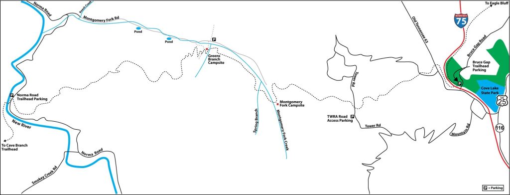
The trailhead for the southern terminus of this section is on Norma Road in Scott County. The northern terminus of the Anderson and Cross Mountain Section is on Bruce Gap Road in Caryville, which is in Campbell County. Directions for the northern terminus are provided for those intending to hike the entire section. Alternative access to Cumberland Mountain Trailhead and unofficial access to Montgomery Fork are provided below.
Southern Terminus: From the west on I-40, take Exit 347 onto US 27N through Harriman and then take TN 61 to Oliver Springs. Take the main street exit into town and turn left onto E. Spring Street, which is also TN 330. In approximately 7 miles turn left onto TN 116. Follow TN 116 about 10 miles to a bridge. Do not cross the bridge, but continue straight on a gravel road that is TN 116/New River Road.Stay on New River Road for 2.8 miles to another bridge (pass Fellowship Baptist Church on the right just before getting to the bridge). Cross the bridge and turn left onto Norma Road/Stoney Fork Road. Drive 4 miles to Smokey Junction. Look for Hembree’s Grocery on the left. Smokey Junction Road turns left, but continue straight on Norma Road for another 2.3 miles to the CT’s Norma Road Trailhead on the right. There is a kiosk and gravel parking area 150 feet north on the left. GPS coordinates are N 36 18.211 W 84 23.147.
To reach the Norma Road Trailhead from Knoxville via Oak Ridge, take I-40 west to Exit 376 toward Oak Ridge on TN 162 (Pellissippi Parkway). Bear left on TN 62 through Solway, cross the bridge over Clinch River, and continue through Oak Ridge toward Oliver Springs on TN 62/61. At Oliver Springs, take the downtown exit right to the intersection of E. Spring Street (a sign points right to TN 330). Follow the instructions above from here.
Northern Terminus: North of Caryville on I-75, take Exit 134 and immediately turn right on Veteran’s Memorial Highway (Old TN 63). You’ll see a Shoney’s Restaurant as you make the turn. Drive 0.5 mile and turn right onto Bruce Gap Road and look for the Cumberland Trail kiosk and parking area on the left.
If you are arriving from the south on I-75, take Exit 134 and turn left onto Veteran’s Memorial Highway, drive to Bruce Gap Road and take a right.
To get from the Bruce Gap Trailhead to the Norma Road Trailhead, return to I-75 and head north from Caryville. Drive 7 miles to Exit 141, and turn left onto TN 63. Follow TN 63 (Howard Baker Highway) 19 miles to the Community of Fairview. Look for Norma Road on the left (south) of TN 63 between a new Family Dollar Store and Ernie’s Tires. GPS coordinates are N 36 22.72 W 84 23.77. Follow Norma Road south for 7.8 miles to the Cumberland Trail crossing. The kiosk and parking area are on the right just before the crossing.
Alternative access via Montgomery Fork Road: Although not recommended, access into Greens Branch and Montgomery Fork Creek is possible, although limited to high-clearance 4WD or all-terrain vehicles; do not attempt this single-track road in a passenger car. Montgomery Fork Road turns east off Norma Road, 5.2 miles south of TN 63 (Howard Baker Highway) or 2.6 miles north of the Cumberland Trail crossing. There are six creek crossings along Montgomery Fork Road, which may not be navigable in any vehicle during high-water seasons. Greens Branch is best located by using a GPS device and using the Greens Branch footbridge coordinates (N 36 19.114 W 84 18.921). You can park after turning around at an ATV trail on the left at approximately 3.6 miles from where you left Norma Road. (Montgomery Fork Road continues on to near the Montgomery Fork campsite; another mile with more creek crossings, but I decided my vehicle had taken enough of a beating and didn’t attempt the drive.)
After parking, walk 100 feet back down Montgomery Fork Road and follow a short path left (could become overgrown) to Montgomery Fork Creek; you’ll see the confluence of Greens Branch on the far side. Cross Montgomery Fork (average 6-8 inches deep except in rainy season) and walk through the woods on the right of Greens Branch. In about 250 yards, you’ll intersect the CT at the Greens Branch footbridge at Mile 7.5 (2.7).
Cross Mountain (Frenchman’s Grave) Trailhead. This trailhead was formerly known as the Tower Road Access. Access to this trailhead may be made by exiting I-75 at exit 134. From the Shoney’s Restaurant, follow Main Street two blocks and turn left. Soon after crossing the railroad tracks, the road becomes Mountain Road. Follow this steep, winding road through a neighborhood of hillside homes, with hairpin curves for 4.6 miles. Make a sharp right where Mountain Road joins Tower Road and continues on an unpaved surface 0.9 mile to another junction. Tower Road continues left and becomes Stony Fork Road. Turn right onto the TWRA road and look for the parking area and kiosk at Cross Mountain Trailhead on the right in 200 feet. Day hikers who access the CT from here will walk down the TWRA road to where the trail crosses the road. Ascend steps to the left to go toward Montgomery Fork, or descend to the right to hike northward to Bruce Gap. Overnight parking is not recommended as there is no security at this trailhead.
Map
Description
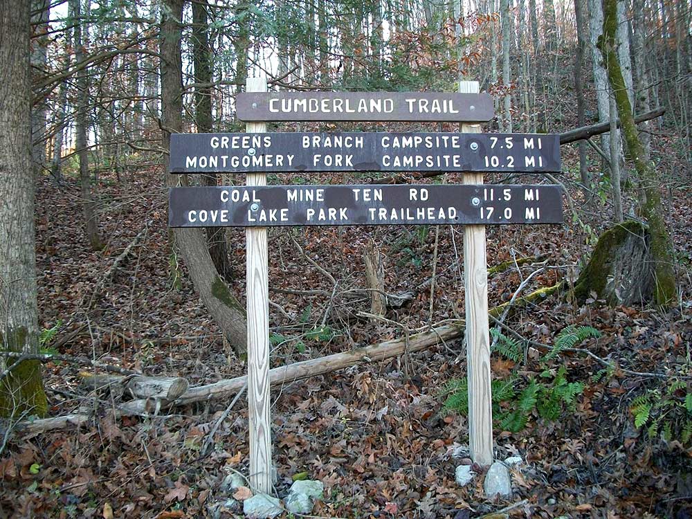
Mile 0.0 (17.0) From the parking area on Norma Road, walk south 50 yards to the CT crossing. This is also the northern terminus of the Lawson Mountain Section, which emerges onto Norma Road from the right. Across the road, on the left, wooden steps built by the Landon Smith Eagle Scout Group Troop 224 in Oak Ridge, mark the beginning of the Anderson and Cross Mountains Section. A trail sign gives distances to the Greens Branch (7.5) and Montgomery Fork (10.2) campsites, to the Coal Mine No. Ten Road (11.5), and to the Cove Lake (Bruce Gap) Trailhead (17.0).
Ascend the steps and then a short steep climb before the trail begins to level out as you make your way southeast for about one mile. Nice views of the New River Valley may be seen seasonally on your right as you gain some altitude.
Mile 0.7 (16.3) A stone bench on the right offers a chance to rest and enjoy the views.
Mile 1.0 (16.0) The trail begins to turn towards the north, and you will pass through a fairly level beech flat before intersecting with an old ATV trail. Follow the ATV trail a short distance, then watch for trail blazes to the right and continue east through a level area with a thicket of young poplar and other saplings.
Mile 1.6 (15.4) Merge right with an old logging road, but watch for the trail blazes on the left, and stacked rocks to indicate the trail. Look for a large room-sized rock on your left. Pass around to the right of this formation and then see another series of large rock outcroppings. Begin another steep climb with switchbacks and a series of short rock steps. Watch your step closely when hiking in fall or winter as these rock steps may be covered with wet leaves. The trail merges with two other old roadbeds. Watch for the 2 x 6 white blaze signs as you continue this rather stiff ascent. You begin to see an open area toward the north and on your left, but the trail will leave the old roadbed and continue east before you get to the clearing.
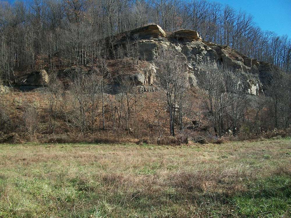
Mile 2.2 (14.8) Enter a small strip bench and join an old road with small pines scattered among the hardwoods. Notice the large white sandstones that have dislodged from the bank straight ahead. Before continuing up through the sandstone bank, go 15 yards to the left to view a small pool of water on the bench. Although this is a good source of water for deer, turkey, and other small game and fowl, the water is not safe for human consumption because of leaching from former surface mining. Retrace your steps and watch for the blaze sign on the left. Work your way through the sandstone rocks and continue to ascend Anderson Mountain. You’ll approach and pass to the left of a large flat rock standing on its edge. The elevation is approximately 2325 feet. Take time to enjoy the impressive seasonal views here with panoramic glimpses of distant mountains and valleys to the north. Evidence of previous strip mining is noticeable on many of the mountaintops. Clear-cut logging has left many areas stripped of the large timbers, exposing a network of logging and ATV trails.
As you continue, look for blaze signs indicating the trail to the right and following an old roadbed along the southeast contour of Anderson Mountain. The trail leaves the roadbed to the left and makes a few switchbacks before leveling off as you approach a large strip mine bench.
Mile 2.7 (14.3) Follow the blaze signs closely through the thickly overgrown area of the bench for about 0.5 mile. Notice the high mining wall on the left and occasional seasonal views toward the south on the right; at one point, you can see wind turbines on Buffalo Mountain more than 20 miles away. This is prime wildlife habitat, evident from tracks in the moist clay soil, deer rubs and scrapes, and turkey scratches. At the east end of the coal mining bench, merge into a roadbed and follow it through the forest until you come to a gap and road crossing.
Mile 3.4 (13.6) A CT sign and directional markers are posted on a wooden post as you arrive at Anderson Mountain Gap. The trail follows the road to the right for about 0.5 mile, and then leaves the road on the left. Watch for the blaze sign. Switchback uphill to a small gap between two higher peaks. Follow the ridge to the right; notice the young chestnut trees and the vista views as the trail winds around toward the north.
Mile 4.1 (12.9) Merge right with an old roadbed and soon enter the west end of Upper Anderson Meadow. This meadow is the result of coal mining operations that occurred here in the 1950s through the 1970s. The top of Anderson Mountain was removed in order to expose the shallow coal seams, a practice called “mountaintop removal.” Following the extraction of the coal, the topsoil was replaced and planted in vegetation. The thick stand of grasses and young locusts and clusters of other bushes make suitable habitat for elk and other wildlife. However, this form of coal extraction can be the most devastating for water quality as the “overburden” is often pushed down the mountain into the stream valleys, especially with present-day operations that can be much larger. Conservation groups are working to ban mountaintop removal.
On the right (south) edge of the meadow is a steep escarpment created by the same mining activities, using a process called “open cut” operations where the mountainside was blasted or cut away, exposing coal seams that lay beneath the surface. These “high walls” are not as easily reclaimed, but the bench created at the foot of a high wall will in time support re-growth of vegetation.
The trail follows the southern edge of the meadow. You’ll see a Cumberland Trail sign and blaze on a post near a cluster of three cedar trees. Looking ahead, you can see the next sign; there the trail turns toward the right. The elevation here averages 2550 feet, providing unparalleled 360-degree views. South across the New River Valley, you can see the northern slope of Poor Mountain. Notice the terrace-like lacing of roads and trails that mar the sides of these beautiful mountains. On the more distant mountaintops and ridges, you may be able to count more than 15 wind turbines on Buffalo Mountain. As you follow the signs across the meadow, pause to take a look at the semi-circular shaped escarpment on your right, but be careful to stay well back from the eroding edges of the almost sheer face of the high wall.
Mile 4.6 (12.4) As you leave the east end of Upper Anderson Meadow, follow the blaze signs down an old roadbed. In July, you may be able to pick some blackberries as you enter the woods. Continue down the old road, then follow the trail left.
Mile 4.9 (12.1) Switchback down to the west end of Lower Anderson Meadow. As you near the meadow you can see evidence of clear-cutting across the hill toward the north. Watch for elk and other wildlife. This meadow also has been reclaimed and returned to animal-friendly habitat following the coal mining operations. Follow the northern edge of Lower Anderson Meadow, staying near the woods on the left. The trail joins a road for a short distance before cutting through the edge of the woods and re-entering the meadow. Straight ahead you will see another 150-foot high wall that was left after surface mining was done in the gap. Bear left and follow the signs to the east end of Lower Anderson Meadow.
Mile 5.3 (11.7) A signpost marks where the trail re-enters the forest. The trail then generally follows the contour of the mountain north until it loops right toward the east-southeast. As you follow the contour along the northern slope of the mountain, a large wooded cove lies on the left, with magnificent old-growth trees. (When I hiked this section in late November, the mountain hid the sun by 12:00 noon.) The trail passes on the north side of a large rock outcropping, which can be seen once the leaves have fallen.
This is a beautiful and peaceful hike as you follow the curvature of the mountainside, eventually heading north onto McCoy Ridge and beginning your descent down the narrow ridge. The trail crosses an old ATV road. Spring hikers will see many wildflowers, including trillium, iris, and violets. Listen for birds chirping as they flit from tree to tree. Fall and winter hikers will enjoy the longer views through the open hardwood forest to the valleys below and mountains in the distance. This is prime animal habitat, so also watch for deer, turkey, and elk. Squirrels are attracted to the hickory trees scattered throughout this section. As you descend the ridge, McCoy Branch heads up in the hollow on the left and empties into Montgomery Fork Creek a mile or so away. On the right, Greens Branch begins farther to the south and flows north toward Montgomery Fork Creek.
Mile 6.8 (10.2) The trail makes a short right turn where the ridge divides and continues to the right, passing left of some large rocks perched precipitously on the ridge. At this point, you are approximately 0.7 mile from the Greens Branch footbridge. From here the descent is more difficult, meandering around and through rocks and down steep switchbacks.
Mile 7.3 (9.7) The trail descends by way of stone steps to an ATV road, which has descended about half a mile from Montgomery Fork Road; this rough road could be walked but is not recommended for driving access to the CT. Turn left on the road for about 200 yards and watch for the white blaze marks indicating that the trail turns back to the right following a short ATV trail. Turn left at the next sign and maneuver a few switchbacks and stone steps down into the Greens Branch valley.
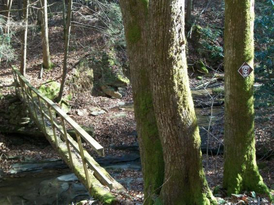
Mile 7.5 (9.5) Reach Greens Branch. Notice the change of undergrowth here, with rhododendron close to the creek, laurel higher on the ridge, and hemlocks scattered among the canopy. Follow the trail 100 yards to the footbridge crossing. A path comes in from the left that is the alternative access from Montgomery Fork Road.
In 2013, the wooden bridge is old and needs replacing, so be cautious in crossing. An option is to ford the creek just above the bridge until a new bridge is in place.
If you decide to camp in this area, look for suitable sites on the hill to the left of the trail, just before getting to the bridge. Or walk a few hundred feet downstream, where there’s some level ground. NOTICE: Greens Branch has not been designated an official campsite, but you can camp practicing “leave-no-trace.” For Leave No Trace Principles, go to: http://lnt.org/learn/7-principles. If you are hiking south from Greens Branch to Norma Road, there is no water source after you leave Greens Branch, so fill your water bottles here. All water must be filtered or treated.
On the other side of Greens Branch, make a steep ascent through mountain laurel and hardwoods for about 0.2 mile before leveling out and following the contour of the ridge.
Mile 8.2 (8.8) Scramble through a rocky section and continue through the open woods. Spring hikers will enjoy displays of wildflowers, ferns, and other plants.
Mile 9.4 (7.6) The trail descends rather quickly to Spring Branch. The wooden footbridge that was built more than a decade ago has rotted and washed away. Cross the creek just below the old bridge site and make a short climb to an old roadbed; turn left and follow the roadbed 100 yards. The trail leaves the road on the right. Where the trail turns off the road, make a short climb and continue around the contour of the ridge.
Mile 10.0 (7.0) Descend to Montgomery Fork. There is no bridge over the creek, but rock hopping may keep you from wading except during heavy rain seasons. On the other side, follow the trail a short distance upstream and turn left to climb the hill.
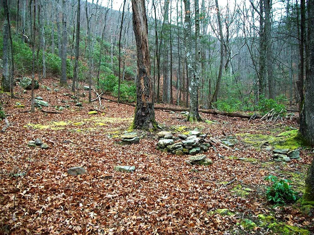
Mile 10.2 (6.8) Look for a sign that indicates the spur trail to the Montgomery Fork Campsite on the right. In about 200 yards on this side trail, the campsite sits on a bench near the creek. There are no smooth tent sites here, but there is a stone fire ring and flat rocks for sitting and cooking with camp stoves.
To continue northeast, be sure to fill your water bottles here, as there is no water source until you reach Duncan Branch at Mile 14.2. Again, it’s safe to drink the water only if it is filtered or treated.
From Montgomery Fork, ascend a short but steep section with switchbacks and rock steps before reaching a fairly level area that turns northward and skirts the steep ridge which is now on your right. This is easy hiking for 0.2 mile. The trail turns right, leaving the scattered stands of evergreen hemlock trees and occasional mountain laurel as you now climb through a more deciduous forest of oak, hickory and other species. Reach a short ridge. The CT continues left along the ridge and passes by a large rock outcrop on your right. After passing below the rock formation, climb the series of rock steps and follow the trail up a ridge. On your left you will notice a narrow flat section of forest with tall white oak and poplar timber. Continue to follow the ridge until the trail gradually turns left onto an old road or strip mine shelf. You may see flame azalea if you are hiking in mid-May to mid-June. You’ll begin to notice residues of coal, the evidence of strip mining that occurred in the 1930s to 1950s. A few fist-sized chunks of anthracite, the variety of coal that was extracted from the sides of the mountain, may be found.
Begin to ascend steeply up steps switch-backing through a series of tiers that are the result of past surface mining.
Mile 11.5 (5.5) Reach No. 10 Mine Road (N 36.18.26 W 84.17.08; elevation: 2,462 feet). This road is variously named No. 10 Mine Road (apparently referring to one of the coal mines operated by the High Point Coal Company from about 1905-1950) and Mine Road No. 1 (currently used by Cumberland Trail State Park officials).
Turn right and look across the road 75 feet ahead for the trail sign. The trail climbs from the road through a strip mine cut with steps and wet spots. Be careful, as the trail can be slippery, especially in winter and spring. In a short distance you will pass between some large room-sized boulders and the trail incline is less steep. In 200 yards, the trail enters an old roadbed to the right. You will find this a welcome relief after making the steep climbs from Montgomery Fork. Besides the pleasant view looking to the right into the Montgomery Fork watershed, the trail is a soft bed of grass in late Fall through early Spring. From June through September there may be tall grass, weeds, or briars unless the trail has been cleared recently. Looking below on the right approximately 400 yards and also across the valley, one can see the No. 10 Mine Road winding its way south through the valley and the ridge on the other side. Notice that heavy logging and possibly a fire has resulted in a sparse older growth of a mixed hardwoods and a much younger under-canopy of poplar, maple, sourwood, sassafras, and other growth. In 0.5 mile the trail continues to follow the road as it now makes a left turn and climbs toward the Big Bruce Ridge. Before reaching the ridge the trail leaves the road on the left and ascends through a rock garden until it crosses an old road that connects Big Bruce Ridge with Cross Mountain.
Mile 12.0 (5.0) Big Bruce Ridge crossing. The trail crosses the road, makes a couple of switchbacks down a short steep grade and begins to follow the contour of Cross Mountain. This is a beautiful section of trail with many wildflowers in the spring and views of the open woodlands with tall poplar, white and chestnut oak, wild cherry, and other species allowing seasonal views of the nearby valleys and ridges. It is also elk territory; the open clearing that can be seen on the right is prime elk habitat that has been partially cleared and sown in grasses. This large half-mile by 400- to 500-foot strip of meadowland with privacy clusters of small trees and bushes provide ideal grazing and bedding opportunities for elk, deer, turkey, and other small game. It also provides the right-of-way for electric power lines that run across the mountain from Caryville toward Scott County. At the east end of the meadow, as you pass under the high-voltage power lines, you will also cross over the 3,000 elevation level, and between here and the Frenchman’s Grave Trailhead, you’ll ascend to 3,060 before beginning a 2,000-foot descent to the Bruce Gap Trailhead at Cove Lake.
The first wildflowers begin to emerge in early April, with several varieties of trillium showing their beauty by mid-April. Hikers who are fortunate enough to be on this section of trail in late May and early June will be rewarded with a display of Flame Azalea and other wildflowers, particularly along the eastern edge of the contour before crossing under the power lines at the end of the meadow.
The trail continues to follow the contour of Cross Mountain, passing by a large tulip poplar, a small branch, and coming to a seasonal viewpoint at the end of a ridge that allows wonderful views of Caryville, Devil’s Racetrack, and Interstate 75. Notice how small the vehicles are as they wind their way up the mountain and by Devil’s Racetrack (see Eagle Bluff Section).
In a short distance, a sign informs the southbound hiker that Montgomery Fork is 2.9 miles. In 100 feet, descend the steps onto TWRA road.
Mile 13.1 (3.9) Descend to TWRA road with Cross Mountain (Frenchman’s Grave) Trailhead and Parking (N 36.17.53 W 84.15.51, elevation 3,042 feet) to the right. Origin of the name “Frenchman’s Grave” is unknown but is used by Cumberland Trail State Park staff. The information kiosk and parking area is approximately 350 feet to the right along the TWRA road; on the left where the road intersects with Tower Road.
To continue north to Bruce Gap, look 30 feet to the right. The trail drops off steeply on the left side of the road to descend to an old coal strip mine bench. Follow the CT signs along the bench a short distance. A sign will indicate a left turn off the coal bench. You will now descend along a ridge to a point, where the trail leads left. Cross a small stream with seasonal cascades and continue right to a second coal bench below a 60-foot sheer rock bluff-line. Look for the CT sign that indicates a left turn and descend through a rocky section into the Duncan Branch gorge. This is another section where many wildflowers showcase themselves from early April through May. Just below the coal bench you may see scraps of metal or other indications of living quarters or work shanties that were there during the coal mining days.
Mile 14.2 (2.8) Cross Duncan Branch to the north side. You’ll come to a short wet-weather wooden bridge and then begin to descend again toward Duncan Branch, but the trail will make a sharp left turn into an old logging skid road. The trail winds along the contour of the ridge and reaches a point where utility lines lead up the mountain. At this point, the CT makes a sharp right turn and switchbacks a few times before continuing along the contour. After a short climb, you will enter the old Royal Blue Railroad Incline bed. The CT sign will direct you to go right (down) on the road. In 0.1 mile look for another sign directing you left down a short set of steps and into the Adkins Branch bottom. Follow the branch until you come out on a dirt road. Turn left and in 50 yards re-enter the woods, climb over some rocks, and cross the stream. Follow the direction of the stream to a large rock outcrop, where the trail makes a right turn and weaves its way between rocks toward the branch. Near Adkins Branch, the trail again turns left and ascends to and crosses a ridge. After passing an old dwelling site, there will be an abandoned information kiosk on the left and a large boulder on the right. From this point, you will soon descend some steps onto the L&N/CSX Railroad. Turn right for 200 feet and look for a sign on the left, which will lead through an easement between the railroad tracks and Highway 63. Cross the road and descend a few steps to the trail, which turns left between Highway 63 and Cove Creek. Approach a steel footbridge known at the Red Ash Bridge. The name “Red Ash” derives from the Red Ash Mining Company that mined coal in the area. A large mining community developed along the railroad tracks and Cove Creek incorporating several coal mining companies.
Cross the bridge and turn right. The CT now follows the contour between Cove Creek on the right and Interstate 75 on the left. You will hear the interstate traffic noise for the next 0.5 mile before passing beneath the interstate bridge over Cove Creek. In 0.2 mile, signs indicate Bruce Gap Trailhead to the right, and the continuation of the CT northward to the left. A portion of the Cove Lake State Park’s Volunteer Loop merges with the CT at this point.
Mile 17.0 (0.0) Turn right for 200 feet to the Bruce Gap Road Trailhead at the northernmost terminus of the New River Segment and the southernmost terminus of the Cumberland Mountain Segment.
—Willie R. Beaty, TTA / CTC Member
More Information
TVA manages a total of 18 wind turbines on Buffalo Mountain in Anderson County at Wind Rock Park.
Originally begun with three turbines built in 2000, the project was expanded to its present capacity with the addition of 15 turbines in 2004. The wind turbines are located along a two-mile stretch of ridgeline to intercept the wind and together produce about 29 megawatts of electricity, or enough to power 3,750 homes.
The newer turbines stand approximately 260 feet tall, with blades that span 135 feet, and can be seen from many miles away. The turbines are capable of producing their maximum output of electricity when wind speeds are 10-25 miles per hour. —WB
For more information: http://www.tva.gov/greenpowerswitch/wind_faq.htm.