Tennessee Valley Divide (South)
Wilson Cap to Tank Springs
Overview
This section of the CT was one of the original sections blazed back in the early 1980s. Later, the path was left to grow over when the trail was temporarily abandoned by the state in 1991.
This section of trail will be revitalized in the next few years. At this time, what’s left of the Cumberland Trail climbs from Tank Springs steeply to the crest of Cumberland Mountain. Here it mostly parallels the escarpment, then drops sharply off the crest’s south side. Though blazes can still occasionally be seen, ATV trails follow much of the original path and other four-wheeler tracks spur off the main ATV route.
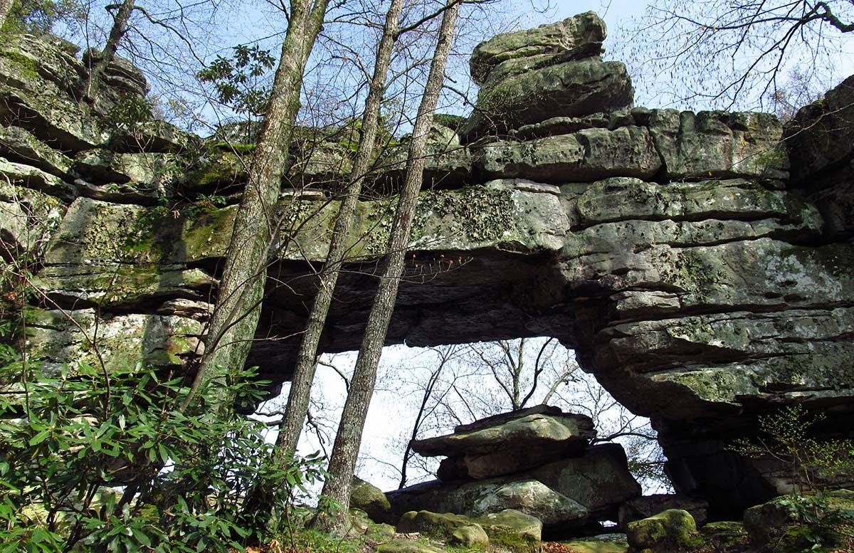
Rock overlooks are numerous. Window Rock, a natural bridge, and Alum Cave, a rock house with a waterfall, are among many geological highlights that also include McLean Rock, the site of the original 1965 proclamation to develop the Cumberland Trail. In the trail’s current state, I recommend using a topographic map loaded GPS to aid your navigation.
Note: The private Mount Cloud gated community stands atop the mountain and lords over the crest for a couple of miles. Hiking this section currently requires traversing roads through the property, which is permitted.
Trail Section Details
Features:
- Overlooks
- Wildflowers
- Fall color
Counties:
- Campbell
Distance:
18.5 miles
Difficulty:
Strenuous
Elevation Change:
1,760 feet gain and loss
Northern Terminus:
Wilson Gap(N36° 28.637′, W83° 54.311′)
Southern Terminus:
Tank Springs (N36° 23.299′, W84° 7.526′)
Timezone:
EDT
Cautions:
For experienced outdoors people only; trail has not been maintained in several years; until trail is revitalized, navigation will be difficult; numerous ATV trail intersections
Camping:
None at this time
Topographic Maps:
LaFollette, Well Spring Quadrangles
Trailheads
NOTE: This description reads South to North.
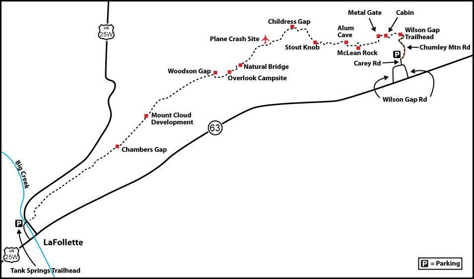
The southern end of this section is accessible from I-75 exit 134, near LaFollette. Take US 25W/TN 63 north for 8.2 miles to LaFollette and turn left at traffic light #9 (the traffic lights are numbered), Indiana Avenue. Follow Indiana Avenue north for 0.4 mile to a signed left turn for Justin P. Wilson Cumberland Trail State Park at Tennessee Avenue. This CT section actually starts on the east side of Indiana Avenue, but there is no parking on Indiana Avenue; so turn left at this junction and cross Big Creek. Turn right into the Tank Springs Trailhead parking area immediately after crossing Big Creek. Tank Springs Trailhead is also the northern terminus of the Eagle Bluff Section.
To get to the northern end of this first piece of the Tennessee Valley Divide Section, continue northeast through LaFollette. US 25W turned left with Indiana Avenue, so now you’re on TN 63. In 13.1 miles, Wilson Gap Road is on the left. (Note: Wilson Gap Road makes a circle, joining TN 63 twice. Therefore, if coming from Harrogate, you can turn at the first Wilson Gap Road or continue to this second turn at Wilson Gap Road described here).
Coming from LaFollette, turn left on Wilson Gap Road and follow it for 0.8 mile. Turn left on Carey Road. Follow it for 0.4 mile, passing Chumley Mountain Road on your right just before dead-ending at a turnaround. To access Wilson Gap, walk up Chumley Mountain Road as it turns to gravel and passes a cemetery on your left; the road then becomes impassable by vehicle, climbing sharply and becoming very rough. It’s a total of 1.2 miles up Chumley Mountain Road to Wilson Gap.
Map
Description
Tank Springs North
Mile 0.0 (18.5) From Tank Springs Trailhead, walk the road back across Big Creek and turn left on Indiana Avenue to the beginning of the trail on the right. On the trail head east, passing the old, faded sign indicating the Cumberland Trail. It states, “No Open Fires, Use Designated Campsites.” Walk a roadbed 100 feet then pick up rotting wooden steps that climb steeply. In 2012, the trail is clear for a quarter mile, then is obscured by blowdowns. Angle directly for the crest. Watch for ATV trails connecting to LaFollette.
Mile 0.7 (17.8) Crest out after gaining 800 feet in 0.7 mile. You are now on the ridgetop of Cumberland Mountain, just short of 2,000 feet in elevation. Rock outcrops adorn the western edge of the ridge above Big Creek. Pick up a roadbed and begin the northeasterly journey atop the mountain. The path stays on the southeast facing escarpment most of the way. Wildflowers such as false Solomon’s seal, white trillium, chickweed, mayapple, and wild geranium are common in Spring, especially on the downhill north-facing slopes.
Mile 0.9 (17.6) Undulate on the mountain, slipping over the southeast side of the mountain when upthrust rocks emerge from the crest. A variety of hardwoods rise overhead, from regal tulip trees to maple and white oaks, beech and black birch. Pines gain hold on drier sites and thin soils.
Mile 1.4 (17.1) Drop to a gap, dipping below 1,900 feet. Sounds from Powell Valley drift up to the ridgeline.
Mile 1.6 (16.9) An ATV track cuts left for Big Creek and US 25W. Almost all rogue ATV trails cut over to the northwest side of the mountain; the escarpment dropping to the Powell Valley is too steep for vehicular travel. If you are in doubt, stay along the edge of Powell Valley. The faint old CT runs alongside upthrust rocks in a dense forest of young trees.
Mile 2.0 (16.5) The crest-running ATV path rejoins the ridgeline. Generally, the ATV paths will drop off the mountain and then climb back to the crest after getting around outcrops.
Mile 2.2 (16.3) Stay right at an intersection, still on the main ATV track. Dip to pass alongside a huge outcrop to your left, and then pass under a power line.
Mile 2.7 (15.8) Pass the first of two more ATV tracks leaving left for Big Creek.
Mile 3.2 (15.3) Swing around the south side of a knob, descending sharply amid craggy pines. Views open up of TN 63 below.
Mile 3.3 (15.2) Pass under a huge power line at Chambers Gap. The clearing affords views north into Big Creek Valley as well as southeast into Powell Valley. A maintenance road comes from the right. Follow the power line right of way down to the low point of Chambers Gap, drop over to the northwest side of the mountain, then climb very steeply back to the crest. From here, you stay above 2,000 feet all the way to Wilson Gap.
Mile 4.3 (14.2) A grassy road crosses the mountain crest. Keep straight.
Mile 4.6 (13.9) Slice between exposed rocks. Stay along the crest. Occasional mountain laurel and rhododendron add a touch of year-round greenery.
Mile 4.8 (13.7) Come to a gate. You are entering the mountaintop community of Mount Cloud, a 1,300-acre tract situated at 2,700 feet. It has many geological features within its bounds but is private; you are permitted to walk the road to pass through, but otherwise respect private property. Follow the road as it dips to the northwest side of the mountain. This was a hang gliding jumping off point for decades.
Mile 5.4 (13.1) On the right, an outcrop has a set of metal stairs that climbs to a view of Powell Valley below. The road passes homesites and becomes paved.
Mile 5.6 (12.9) Pass the entrance gate to Mount Cloud Restaurant, which is open to the public with reservations. (The Mount Cloud property provides access to the CT only with restaurant or lodging reservations; this is not general public access.) Keep straight on the paved road, passing more houses and lots.
Mile 6.6 (11.9) Leave the resort property; note the Tennessee Department of Environmental Conservation property marker. Join a lightly used ATV trail along the mountain escarpment in an alluring hardwood forest littered with rocks. The land you are traversing is part of the December 2009 purchase of land from the Molpus Woodlands Group, a Mississippi-based timber firm. The Trust for Public Land purchased the 1,388 acres for a little over two million dollars, establishing a 200-foot wide corridor stretching for 19 miles all the way to Cumberland Gap, which the CT will follow once re-established. Look for faint blazes amid the oaks. Winter views are frequent to the southeast.
Mile 7.6 (10.9) An outcrop with open view is on your right, just a few steps off the trail. The still, upper bays of Norris Lake stand out among the farms and hills with the Appalachian Mountain crest on the Tennessee-North Carolina state line forming a backdrop.
Mile 7.7 (10.8) Pass by a rock pillar distended from the mountain to your right. The CT then travels atop a rock slab open to the overhead sky. Watch for white stonecrop blooming in Spring.
Mile 8.0 (10.5) Split between some massive boulders. Masses of white trillium carpet the north side of the mountain in April. Wintertime views open of a gray stone wall rising above a tributary of Davis Creek.
Mile 8.9 (9.6) Reach Woodson Gap. Old CT signs indicate the Overlook Campsite 0.5 mile and the Natural Bridge as 1.0 mile distant. An old road drops off both sides of the mountain. The CT winds up the ridge, still northeasterly.
Mile 9.1 (9.4) Resume undulating on the mountain.
Mile 9.4 (9.1) A four-wheeler trail drops off the ridge while the CT winds amid rocks.
Mile 9.6 (8.9) Come to a rock outcrop and incredible overlook. Here, the greater Clinch River Valley spreads forth, including the upper embayments of Norris Lake, along with hills and valleys stretching south to the far Great Smoky Mountains. The CT continues northeast along the escarpment and reaches the old Overlook Campsite. A wooden table still stands here, a little back from the drop off, in oak woods. Water can be had from the creek on the north side of the gap back at 8.9 miles, or the spring below the Natural Bridge, ahead 0.4 mile.
Mile 10.0 (8.5) Reach the Natural Bridge. Here, a large window has formed from a collapsed rock rampart. Locals refer to it as “Window Rock” because it can be seen from TN 33 below when leaves are off the trees. The opening is about 15 feet high and 25 feet wide with collapsed stone beneath it.
The bluff prevents passage along the escarpment, so the CT curves left away from the rim and dips along a rhododendron-choked spring before curving northeast, once again along the escarpment. Ahead, you can see the curve of Cumberland Mountain around the upper valley of Doakes Creek.
Mile 11.2 (7.3) Come along a bluff line, level area, and non-designated campsite. A jeep track heads left for Little Tackett Creek. Stay right, turning sharply downhill, passing a spring before turning left and climbing over a knob.
Mile 11.3 (7.2) The trail splits on either side of the remains of a forgotten plane wreck. Keep steeply downhill along the escarpment.
Mile 11.8 (6.7) Come to an easterly vista as you walk over an open rock slab. Begin descending to Childress Gap.
Mile 12.5 (6.0) Reach Childress Gap above Doakes Creek. A jeep track leaves left for Little Tackett Creek. Climb through pines and over rock slabs. Circle the head of Doakes Creek.
Mile 13.7 (4.8) Top out on Stout Knob. Drop, then continue undulating on the mountain edge. Swing around No Business Creek drainage to your north. Jeep and ATV trails become wider and more prominent.
Mile 14.8 (3.7) Rise to a four-way junction just after dipping to pass a spring. This is the Alum Cave rock house, spring, and waterfall area. It has been decimated by ORV traffic and trash. An old CT sign stands in the woods on the escarpment to your right. This area would be a major highlight, but frankly has been abused. The road to Alum Cave goes left and a trail keeps straight that leads to Tackett Creek. To continue the CT, turn right, shortly passing old CT signs to the right of the trail. The path is now muddy, eroded mess.
Mile 15.3 (3.2) Reach McLean Rock on your right. It is heavily graffiti-ed and generally trashed, but the view remains impressive as it was when the 1965 announcement to establish a Cumberland Trail was launched from this site. The panorama extends as far as the eye can see. It’s best to look out, rather than at the embarrassment of trash, erosion, and abuse of the area. The site will improve as the CTC reclaims the area. Turn left here, circling below McLean Rock, on a standard gravel road.
Mile 15.6 (2.9) Come back along the escarpment.
Mile 16.5 (3.0) Turn right at a metal gate, as the main road you are following dives north. Walk along a dirt track, open onto a field, passing a cabin on your left and a pond on your right. The main track descends forward in woods.
Mile 17.3 (1.2) Reach Wilson Gap where the faint CT footpath continues northeast. A four-wheel track, the upper part of Chumley Mountain Road, descends right, south. Follow the badly eroded track downhill to leave the CT.
Mile 18.5 (0.0) Reach paved Carey Road after passing a house and pond and the cemetery. The parking area at the end of Carey Road is to your right upon reaching Carey Road.
—Johnny Molloy, outdoor writer and CTC member