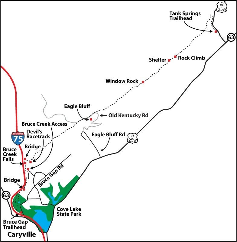
Eagle Bluff
Tank Springs to Cove Lake State Park
Overview
The Eagle Rock Section is one of the most geologically varied and scenic trails in east Tennessee. The trail starts at a trailhead located in Cove Lake State Park, follows I-75 a way, and then climbs to a wonderful lookout atop the Devils Racetrack rock formation that is visible from I-75. Trail is currently closed from here to Eagle Bluff. Thereafter the trail follows a series of often rocky double ridges along the edge of the Cumberland Plateau escarpment to LaFollette.
Along the way there’s a wonderland of rock, including two “Great Walls of China” rock walls, massive sandstone cliffs, a stone arch, and numerous rocky lookouts, with vistas of the Powell River Valley, Cumberland Mountain, and on a clear day the Southern Appalachians. Wildflowers are abundant, especially in the Cove Lake State Park area, and one site provides good camping.
The Eagle Rock Section is part of the Cumberland Mountain Segment of the Cumberland Trail that, when completed, will extend from Cove Lake State Park to Cumberland Gap National Historic Park.
Trail Section Details
Features:
- Waterfalls
- Overlooks
- Wildflowers
- Fall color
- Bluffs
Counties:
- Campbell
Distance:
11.7 miles
Difficulty:
Strenuous
Elevation Change:
3,446 feet total climbing
Northern Terminus:
Tank Springs (N36 23.294 W84 07.557)
Southern Terminus:
Cove Lake SP Trailhead (N36 18.437 W84 13.625)
Timezone:
EDT
Cautions:
The trail is closed for approximately 0.6 mile south of Eagle Rock Road toward Cove Lake State Park due to a trail redesign; Strenuous trail with rocky terrain, steep climbs, and challenging route-finding; One section requires rock scrambling; a bypass route is available; Follow posted closure signs and stay on the designated trail corridor.
Camping:
Trail shelter and tent sites at mile 8.85 (2.85); water available in all but driest months at small creek 0.1 mile west of the campsite
Topographic Maps:
Jacksboro and Ivydell Quadrangles
Trailheads
Bruce Gap Road Trailhead: From the north or south on I-75 take Exit 134 (for Caryville, Jacksboro, and LaFollette and US 25W/TN 63). Coming from Knoxville on I-75 (from the south), at the end of the exit ramp turn left and proceed on Royal Blue Road/Old TN 63 (past a Shoney’s Restaurant) for 0.8 mile. Turn right on Bruce Gap Road and drive 0.1 mile, under I-75, and turn into the Bruce Gap Road Trailhead parking lot on the left. The parking lot is paved and fenced, with an information kiosk a short way down the trail. An access trail to the CT begins at the back left side of the lot. The trailhead is within state park lands; note that across Bruce Gap Road from the parking lot, the Volunteer Loop comes up from the main portion of Cove Lake State Park and continues on the CT until it makes a loop down to the right (east) before reconnecting to the CT and returning on the CT. If you take the Volunteer Loop into the Park from the parking lot, it is 0.1 mile along Cove Creek to a trail sign; turn left and in a couple hundred yards connect with a paved trail, and turn right to access the developed area of the park with picnicking, camping, and a restaurant.
Note: Due to a trail redesign, approximately 0.6 mile of trail south of Eagle Rock Road toward Cove Lake State Park is currently closed. Hikers should follow all posted signs and use the designated reroute where available.
Tank Springs Trailhead: Again from the north or south on I-75take Exit 134 (Caryville, Jacksboro and LaFollette and US 25W/TN 63). Coming from Knoxville (from the south), at the end of the exit ramp turn right onto US 25W/TN 63 and drive east for 8.0 miles. In the town of LaFollette, at Tennessee Avenue (Traffic Light #7), turn left and proceed for 0.4 mile. Just before crossing a bridge over Big Creek, turn left into the paved Tank Springs Trailhead Parking Lot. The trail begins at the upper end of the parking lot, beside Tank Springs.
Map
Description
Important: The trail is currently closed for approximately 0.6 mile south of Eagle Rock Road toward Cove Lake State Park while the trail is being redesigned. Please obey all closure signage and use any designated reroutes.
Mile 0.0 (11.7) At about 300 feet on the access trail from the Bruce Gap Road Trailhead parking lot, intersect with the CT, with the New River Segment going left and the Eagle Bluff/Cumberland Mountain Segment going right. A trail sign indicates 11.7 miles to the Tank Springs Trailhead in LaFollette, which is the next official trailhead. The trail is marked with white blazes (except in one short section of orange/cut blazes) although not consistently and in several places the hiker will need to watch the trail tread instead of relying on the blazes. Four switchbacks followed by a steep ridge climb gets you near the ridgetop, where you can look down to the left (west) into the I-75 corridor and not incidentally will also hear the quite loud traffic noise, especially trucks; sometimes the traffic is also visible.
Mile 0.29 (11.4) The Volunteer Loop turns off to the right, slightly down hill, while the CT continues to climb to the left. An attractive option here is to take the slightly longer and more difficult but scenic Volunteer Loop, which makes a semi-circle below the CT to the right (east). To follow the Loop, the trail traverses out the side of the ridge, then proceeds down the ridge and three switchbacks for 0.4 mile to Powder Springs Beaver Pond, then climbs steeply back up to the CT at 0.56 mile. The Beaver Pond, a huge one-acre plus greenish pond with an old beaver dam near the center, is worth the effort.
After passing this south end of the Volunteer Loop junction, the CT continues along the ridge, with ups and downs.
Mile 0.8 (10.9) Descend via switchbacks to the north end of the Volunteer Loop. Here the CT proceeds left while the Loop goes right (if you took the Loop, you will be coming up from the valley and should turn right on the CT). The trail continues to drop below the junction, crossing an old road and following another one, to a valley where there’s a stream to the right and, as of 2011, two small beaver dams and ponds (much smaller than Powder Springs Beaver Pond). The trail continues over the upper part of the valley and at this point is far below the interstate.
Mile 1.0 (10.7) The trail begins a climb out of the valley, initially beside a creek; in April, notice crested dwarf iris as you start up again. The trail has six switchbacks as it climbs to the top of the ridge again, leaving state park lands, and proceeds along and above I-75 within the interstate right-of-way. Although this portion of the Eagle Bluff Section has interstate noise, which is somewhat ameliorated by the fact that the best wildflowers of the entire Section are found here, between the trailhead and the ascent up to Devils Racetrack. The wildflowers start blooming in late March and early April but are at their peak in late-April into May. Wildflowers and other interesting early spring flora include fiddlehead fern; the blossoms of dogwood, serviceberry and redbud trees; toadshade/wake robin trillium; common blue violet; and early yellow violet. Later wildflowers include yellow trillium, wild geranium, star chickweed, Robin’s plaintain, indian strawberry, yellow trillium, and crested dwarf iris.
Mile 1.6 (10.1) The trail drops to a wooden bridge over a drainage from the interstate. This portion of trail from the Bruce Gap Road Trailhead up to the Devils Racetrack Overlook was constructed in the mid-2000s and is very well built, with bridges and wooden/rock steps. However, the rest of the trail on to Tank Springs Trailhead was constructed in the late 1970s and is more primitive in places and more difficult to hike.
Mile 1.8 (9.9) The trail crosses a fence on a wooden ladder. Be careful here because you are on an old road. To continue on the trail look left to watch for the ladder. From this point going north there are great views of Devils Racetrack just above a curve in I-75, with massive dark stone slabs slanting down the side of Cumberland Mountain straight ahead. The trail passes through an area of somewhat recent tree clearing. An interstate fence is to the left and a house and billboard to the right in this area.
Mile 2.2 (9.5) The trail becomes more difficult as it passes through several boulder fields that are mostly part of the interstate embankment and begins a steep descent into the Bruce Creek Gorge, assisted in places by rock steps. At this point Devils Racetrack is straight ahead.
Mile 2.4 (9.3) The trail comes out onto an old dirt road and turns left, up Bruce Creek and toward a visible waterfall. The old road also goes right 0.1 mile down to Shelton Hollow Lane in the community that lies north of Cove Lake State Park.
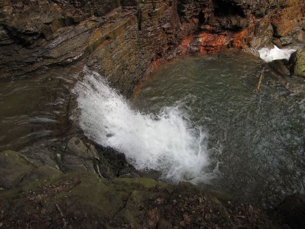
Continuing on the CT, follow the old road to a roaring ten-foot waterfall dropping into a green pool. This falls and the larger falls on up the trail are not natural but were part of the I-75 construction. The trail continues to follow the old road. If you look up at this point you’ll see a closer view of Devils Racetrack looming overhead.
Mile 2.7 (9.0) The road ends and a footpath continues under a fallen log and along the creek. The trail then climbs steeply beside a large series of cascades and waterfalls that total a 70-foot drop. In the center is a 20-foot waterfall. The noise is deafening and drowns out the interstate traffic noise. At the top of the waterfall, a short spur goes straight for a view of the falls while the CT turns left and continues up Bruce Creek.
Mile 2.2 (9.5) The trail becomes more difficult as it passes through several boulder fields that are mostly part of the interstate embankment and begins a steep descent into the Bruce Creek Gorge, assisted in places by rock steps. At this point Devils Racetrack is straight ahead.
Mile 2.4 (9.3) The trail comes out onto an old dirt road and turns left, up Bruce Creek and toward a visible waterfall. The old road also goes right 0.1 mile down to Shelton Hollow Lane in the community that lies north of Cove Lake State Park.
Continuing on the CT, follow the old road to a roaring ten-foot waterfall dropping into a green pool. This falls and the larger falls on up the trail are not natural but were part of the I-75 construction. The trail continues to follow the old road. If you look up at this point you’ll see a closer view of Devils Racetrack looming overhead.
Mile 2.7 (9.0) The road ends and a footpath continues under a fallen log and along the creek. The trail then climbs steeply beside a large series of cascades and waterfalls that total a 70-foot drop. In the center is a 20-foot waterfall. The noise is deafening and drowns out the interstate traffic noise. At the top of the waterfall, a short spur goes straight for a view of the falls while the CT turns left and continues up Bruce Creek.
Mile 2.9 (8.8) The trail crosses a wooden bridge over Bruce Creek and begins a long switchback ascent to Devils Racetrack Overlook. This is the most difficult climb on the Eagle Bluff Section when hiking north (if going south it is an easy descent while the hardest climb is instead up to the ridge above the Tank Springs Trailhead). To this point the trail has climbed a total of 567 feet, so with 3,446 total feet to climb along the rest of the trail, there’s a lot of climbing ahead. Ten switchback grades in the trail get you to the ridge of Cumberland Mountain. You’ll pass a room-sized boulder on the way up and will also note that the trail is moving away from the interstate and its noise will likewise gradually disappear.
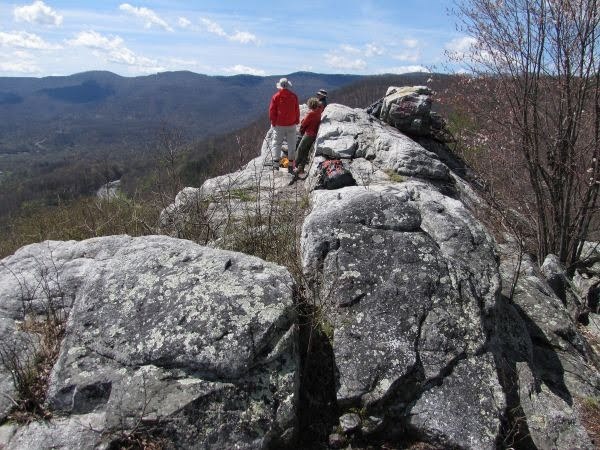
Mile 3.2 (8.5) The trail reaches the ridge of Cumberland Mountain, but north of the Devils Racetrack Overlook. The ridge is relatively barren from a forest fire. At this point, the CT turns left (north) and proceeds along the ridge. However, anyone hiking this far will want to turn right and hike the short 0.08 mile spur trail to the Overlook. The walk out to the Overlook is on whitish grey sandstone and leads to one of the best views on the entire CT. The Overlook is a collection of large rocks that are actually the top of the Devils Racetrack you saw from below. Religious graffiti has unfortunately been painted on some of the rock, but otherwise it is a beautiful place, and a frequent lunch spot or turn-around point from the Bruce Gap Road Trailhead. The view is spectacular, looking down on I-75 as it snakes its way off the Cumberland Plateau and down toward Cove Lake. Fork and Cross Mountains are across the interstate to the west; Cumberland Mountain, which the trail follows, is to the northeast; below is Powell Valley with Cove Lake State Park and Jacksboro visible; and beyond to the south are mountains that stretch, on a clear day, to the Southern Appalachian Mountains and the Smokies. A maintainer of this section of the trail tells of a really foggy morning when he was at the Overlook, and could clearly hear the traffic down below, but could see only a sea of white.
Back from the Overlook, the CT continues to the north, following Cumberland Mountain and its ridges and bluffs while passing through private lands with conservation easements. The almost completely forested North Cumberland Wildlife Management Area lies to the left; the Royal Blue Unit to the west and northwest and the Sundquist Unit to the north and northeast. The developed Powell Valley lies to the right (southeast). Very shortly you will begin to see the geology that characterizes much of the Eagle Bluff Section. Huge vertical rock fins, walls, and blocks protrude from the ridge and the trail follows a serpentine path either on top of or to the left or right of the rock. Even when the trail follows a rounded earth ridge, the rock is buried beneath, waiting on erosion to release it.
You’ll pass the old “Suck Air” route which, prior to the completion of the Bruce Gap Road Trailhead and the trail to Devils Racetrack Overlook, provided access to this end of the Eagle Bluff Section. The trail basically came straight up the side of the mountain from the right (south), but the route is no longer visible. The trees are mainly deciduous, especially various species of oak, which means great views in winter when the trees are not leafed out. However, there are occasional pockets of evergreens, including white pine, especially toward the northern end of the Section.
Mile 3.6 (8.1) The trail comes upon a common scene on this Section. Unlike most ridge-tops, Cumberland Mountain often has two distinct ridges, separated by a low forested valley. One or both ridges are often rock bluffs and walls instead of the more typical earthen ridge-tops. The trail usually follows the right (southern) ridge nearest Powell Valley but sometimes crosses over to the one on the left (north) nearest Royal Blue.
Mile 4.4 (7.3) The trail passes under a power line that runs north to south. Off-road vehicle (ORV) tracks are visible to the north along the power line right of way, as is a dirt road that the trail will shortly cross. The CT proceeds straight across the power line clearing.
Mile 4.8 (6.9) The trail crosses a short Chinese Wall-like formation, ten feet wide and at least that high; a later wall will be even more impressive. A dirt road is visible down below to the left (north).
Mile 4.9 (6.8) The trail drops to the right and intersects an ORV trail. The CT goes left at this point on the ORV trail that appears to come up from the Powell Valley below. Now that the trail has neared several roads, there are lots of signs of ORV abuse of the mountain. In the past ORV drivers pretty much drove wherever they pleased, but as of 2011 there seems to be a bit less traffic. The trail continues to follow the ORV trail, and then intersects a road that’s in bad shape, with lots of huge pools of water and mud. Turn right on the road.
Mile 5.2 (6.5) The road and trail intersect Eagle Rock Road, sometimes referred to as Old Kentucky Road. The CT turns right (northeast) on Eagle Rock Road. Continue along the road; unfortunately, you’ll begin to see litter; the CT itself, away from the road, is remarkably free of litter.
Mile 5.5 (6.2) You’ll see a rounded knoll to the right with a gravel road going to the top, behind a gate with boulders in front of the gate. There’s also a nice foot trail that leads to the top, which is the location of Eagle Bluff. The view from the rock is a must-see side trip. Walk up the short trail to a massive rock that protrudes out over the valley and provides impressive 180-degree view of Powell Valley and beyond (marred slightly by graffiti on the rock itself).
Eagle Bluff (Will Skelton)
Mile 5.6 (6.1) The trail reaches the top of the ridge right below the Eagle Bluff knoll and now turns left (north) off the road; look carefully to the left as you can get lost at this point. The cutting of trees along Eagle Rock Road right of way in 2010 has made the trail’s exit from the road a bit unclear. Essentially you turn left (northwest) off the road at its highest point, and continue out the high point of the ridge. It is possible to drive a 4-wheel drive vehicle up to this point, but safe parking is questionable. Eagle Bluff Road turns off US 25W/TN 63 about 3.0 miles from Exit 134 on I-75; follow Eagle Bluff Road for 0.7 miles to where Lake Road turns right; Eagle Bluff Road proceeds straight but turns into Hilltop Road; proceed 0.3 mile on Hilltop Road and turn right onto Eagle Rock Road that heads up the mountain side. Follow it for 1.0 mile to the top and Eagle Bluff. There is limited parking at the turn on Hilltop Road, if you want to walk up Old Kentucky Road.
Mile 5.8 (5.9) To the northeast, the CT travels through the Sundquist Unit of the North Cumberland WMA. The trail passes a beautiful rock wall, five to ten feet high, that almost looks like it could have been constructed. The wall then gradually slides into the mountain. The trail continues to undulate along the ridges and rocky spines of Cumberland Mountain. There are occasional signs of ORV use beyond Eagle Bluff, but such seems to have lessened substantially in 2011.
Mile 6.0 (5.7) The trail proceeds along the top of a square rocky ridge (and along the left or northern ridge; there’s another ridge to the right, south, that overlooks Powell Valley) and to a point where many hikers get lost when hiking north. As of spring 2011, there are no blazes at this point. The only real clues as to where to turn right off the ridge and descend into the valley between the two ridges are a pile of brush that sort of blocks straight ahead and some ribbons to the right. The trail descent is not clearly visible at this point. So many hikers have missed the turn and gone straight ahead, creating a trail, and end up having to return as the ridge “cliffs out” in a high rocky cliff face.
Look for lots of crested dwarf iris in season as you descend. The trail drops, crosses the valley, and proceeds onto the ridge closest to Powell Valley. The trail then undulates up and down along the ridge, with occasional rock viewpoints.
Mile 6.4 (5.3) An old ORV trail comes up from the left, but a Royal Blue WMA road closed sign indicates the ORV route is closed. The old ORV tracks continue to follow the trail north and at one point the two diverge, with the ORV route going right and the CT left, but they rejoin in less than a tenth of a mile. After they rejoin, continue north on the old ORV track, descending along the right of the customary two ridges toward a gap. Soon the trail gets too rocky for ORVs and from this point to near the Tank Springs Trailhead there are no signs of ORV use.
Mile 6.6 (5.1) After traversing some boulders, reach a gap with rhododendron on the right. Then make a steep climb up the valley between the two rock wall ridges. At the top, the left rock wall temporarily disappears and the trail continues on the right ridge.
Mile 6.9 (4.8) The trail follows the better of the two “Chinese Walls.” It’s a 150-foot-long rock wall, ten feet wide and just a few feet to 15 feet high, looking like a constructed fortress wall. The trail continues along the rocky ridge top where the second ridge has reappeared and then begins steeply descending toward a very low gap that runs all the way through the two ridges of Cumberland Mountain (most gaps only cut through one of the two ridges).
Mile 7.2 (4.5) Reach the bottom of the gap and cross on a rock ledge that extends across the gap, 150 feet high on the south side. The trail continues up the right ridge. After another very steep climb, another high point is reached, and the trail levels off for a bit. A large rock seemingly presents an obstacle, but the trail proceeds on a narrow ledge on the left side of the rock.
Mile 7.5 (4.2) An overlook provides great views Powell Valley but is another opportunity to miss the trail. The trail proceeds steeply straight ahead and up onto a rocky ledge, instead of to the left on dirt, as you would think and as a lot of errant hikers have done. The climb up is precarious since there’s a 50-foot drop on the Powell Valley side, so be careful. As of 2011, there are no blazes indicating the route.
Mile 7.7 (4.0) The trail continues to undulate along the top of the rocky wall and ridge. After slightly heading downhill, the trail passes right beside and to the right of a beautiful rock arch, appropriately called “Window Rock.” A fin of rock protrudes from the ridgetop and toward the gap below; toward the bottom of the fin is the four-foot-high, fifteen-foot-wide arch.
The trail drops a bit and then continues to follow the ridge, sometimes rocky but mainly dirt. You’ll begin to see several private property owners’ signs beside the trail: “No Smoking; No Trespassing.” As you hike much of the ridgetop portion of this Section, there will be occasional sounds of traffic from below in the Powell Valley, but by far the most frequent sound is of the railroad trains blowing their horns. The trail changes to more earth and open-woods walking instead of rock as it gradually descends toward a low gap, and then climbs, with ridges on both side as usual.
Mile 8.6 (3.1) The trail reaches a high point with a view into another gap with a massive dark wall extending on the left side (north) down to the bottom, with a less sheer wall to the right. Beyond the gap is the single campsite with water on the ridge portion of this Section. The trail descends, following the huge rock wall down into the gap. This rock wall is a big one, as will be evident when you walk along it. It is close to 150 feet high and a quarter mile long, gray and slightly yellow sandstone, looking much like the wall of a medieval fortress.
Mile 8.8 (2.9) The massive wall at a very small creek that flows out of a spring nearby. The water is usually reliable in the wetter months of spring and winter but cannot be vouched for in the dry months of summer. Treating the water is of course advised, although it emerges from the ground close by. The trail continues on up the forested valley on the other side of the creek to a large relatively flat area.
Mile 8.9 (2.8) The trail reaches a campsite beside some rock outcrops. The view from the campsite is different from most of the hike; the sights (and sounds) of the Powell Valley are completely blocked by a large ridge to the south, while the views are out over the Royal Blue WMA. On a quiet night, the only sounds will be the occasional railroad whistle and Ollis Creek far down below. The CT continues on down into a small gap beyond the campsite and then climbs to one of the highlights of the hike.
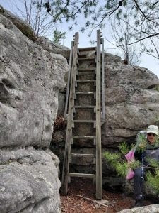
Mile 9.0 (2.7) Up from the gap, the trail follows a rocky spine, between large boulders, and reaches a huge mass of rocks. The trail passes through a crack on the left and reaches an unnamed large rock outcrop, at least 25 feet high. At one time, the official trail ascended the rock, which required some novice rock climbing. But a recent Eagle Scout project erected a staircase for ascending or descending the rock face.
Once on top of the rock outcrop, you are not to the actual high point of the climb. You need to continue up to a higher rock outcrop, but the route on up is much easier around to the right. From all levels, the views are wonderful out over Powell Valley. The trail then climbs gradually higher and along the rocky ridge, often on solid rock, with more outstanding views.
In this area, as the trail is ascending, if you look to the left (north), you’ll see a unique view, especially when the leaves are not out. Below is a gradually ascending valley floor, completely forested, with the two rock walls on both sides. The walls create a corridor that is both unusual and beautiful. The left, northernmost wall is one of the most perfect walls you’ll see, absolutely vertical 100 feet, approximately the same height for much of its length, that glisten in the morning light. The trail follows the right, southernmost wall.
Mile 9.3 (2.4) Near the high point above a rock climb, the ridge to the north (across the low valley) drops to 30 feet or so in height, and there is a breach in the wall just before the high point. That wall then slides over the ridge, and again grows in height as it continues down the other side to a final high precipice, having provided great views for about 0.4 mile. The trail, now mainly an earthen ridge but sometimes rocky, continues to follow the ridge on the south side of the valley. Several gaps and high points are passed
Mile 9.8 (1.9) At a high point there’s again the classic ridge with two rock walls and a low valley in between. The left (north) ridge is much higher and the trail proceeds along that higher ridge, descending gradually. A short ways on, there’s a long rock ledge where it appears some trees have been cut to provide views of LaFollette below to the northeast. Shortly thereafter, the trail crosses over the top and sides of a series of rock outcrops, and then continues along a primarily earthen ridge. At about this point, you’ll note vehicle sounds have returned as you approach LaFollette.
Mile 10.0 (1.7) The trail begins a very steep descent through rock outcrops to an earthen gap that cuts all the way through the ridge. Numerous rhododendrons give a different look to this area. The trail then gradually traverses upward again between two earthen ridges.
Mile 10.4 (1.3) Reach the final high point where the two ridges join. Straight ahead is Big Creek Gap where Big Creek cuts through Cumberland Mountain. The CT at this point turns left and begins a very steep descent into Big Creek Gap. First the walking is easy on an earthen ridge, but after about 0.1 mile the tough hiking begins. The trail essentially follows the rocky spine of Cumberland Mountain as it drops into the gap. The trail wanders on both sides of the rocky ridge, among and around rocks, and is difficult going up or down. A couple of times the trail cuts sharply back to the left and down below a rock wall, and then traverses out the side of the wall to regain the ridge lower down. This descent (or ascent if coming the other way) is by far the most difficult hiking of the entire section. In places, the trail is simply the easiest path over the rocks. Lots of maneuvering over and around the rocks is required.
Mile 10.8 (0.9) Reach some rock steps and make a more gradual descent along a still rocky ridge top. The trail finally leaves the rocks and begins a descent on the earthen mountainside to the valley below. A side trail will go off sharply to the right at a ridge switchback, but it simply goes a short distance to a viewpoint. A sign in the reverse direction indicates the main trail goes up the ridge at this point. The trail continues the steep descent but with the assistance of some trail switchbacks and rock and wooden steps. There are lots of common blue violets and early yellow violets along this section in April.
Mile 11.0 (0.7) The trail passes a massive concrete foundation, probably left over from a logging or railroad structure. The trail cuts sharply to the left (west) and continues to switchback downward. Shortly thereafter is an overlook where trees have been cut to provide a view of the scenic CSX railroad bridge over Big Creek. The trail then picks up an old road down to the Ollis Creek Valley, just above where Ollis Creek flows into Big Creek. Both creeks are scenic and have a lot of flow in wet weather.
Mile 11.1 (0.6) The trail passes under the CSX railroad bridge and turns right (east) onto an old railroad grade. The trail then follows the railroad grade, with Big Creek on the left and the CSX railroad tracks now up to the right. The trail is perfectly level and easy walking with the only difficulty being several wet areas fed by springs coming out of the mountain you’ve just descended. You’ll see the foundations of some long-gone structures in the middle of the trail.
Mile 11.7 (0.0) Just short of the Tank Springs Trailhead, there’s a trail kiosk with mileage signs. The trail continues out to a red gate and beyond the long paved Tanks Springs Trailhead and parking lot in this small City of LaFollette park. Tank Springs gushes out of a concrete wall in two to four streams of water, depending on rainfall. The water comes from under the railroad embankment; there’s so much water that some of it also flows to the sides. The spring is very popular with local residents, and if you wait around for a few minutes on a weekend day, a procession of people will drive up to get a drink.
— Will Skelton, CTC Board Member; Head of the Cherokee National Forest Wilderness Coalition; editor of Cherokee National Forest Hiking Guide; later led the Knoxville Greenways Commission; Knoxville’s “Will Skelton Greenway” named in recognition of his greenways work.
Updated 3/31/26 by Deb Westervelt
More Information
Devils Racetrack and I-75
The impressive Devils Racetrack rock formation is located to the east of I-75 as it heads up onto the Cumberland Plateau and Cumberland Mountain. Morgan Simmons, a Knoxville News Sentinel writer, called Devils Racetrack “a rock formation so eye-catching it challenges you to keep your eyes on the road.” The CT climbs to an overlook at the peak of the rock formation. Devils Racetrack was formed 250 million or so years ago during the Allegheny Orogeny when the North America and Africa plates collided. In the Cumberland Mountain area, layers of sedimentary rock, mainly sandstone and shale, were tilted by the compression from horizontal to vertical. At the southwest end of the mountain, Devils Racetrack was formed when the softer shale rock eroded away, leaving only the vertical quartzite sandstone that now remains. No one seems really sure about the source of the Devils Racetrack name, except that it would be a hell of a place to race.
Interstate I-75 was constructed below the Devils Racetrack in the mid-1980s and subsequently permission was given to locate the CT on the I-75 right-of-way. As a result, the trail follows the east side interstate embankment for much of the first 2.2 miles from Bruce Gap Road Trailhead. Because of a concern that Bruce Creek would erode the interstate embankment, the creek was moved about 40 feet toward the Devils Racetrack mountain, with the relocated stream being partially enclosed in a culvert, and in other places artificial waterfalls and pools were created to dissipate the stream’s flow. The waterfalls now provide scenic highlights for this Section. —WS
Old Kentucky Road and Eagle Bluff
In 1805 the Tennessee legislature authorized a road “…over Cumberland Mountain to the Kentucky line, to intersect the road to be opened by the State of Kentucky from Danville to the Southwest Point.” That road was subsequently constructed and became what is today called “Old Kentucky Road.”
The road climbed up to the crest of Cumberland Mountain near Eagle Bluff and proceeded along the crest for a mile before turning westward to Stinking Creek and an ultimate destination of the Cumberland River. It was a rough wagon track maintained by citizens, and in the 1800s a village was located just west of Eagle Bluff. However, with railroads and better highways, Old Kentucky Road fell into disuse and disrepair, and on the 1991 USGS topographical map of the area, it is shown only as a trail. Subsequently, Campbell County improved the trail into a still rough and steep gravel/dirt road and installed underground sewer, water and electricity along the road, all to benefit a proposed residential development to the north. The development failed, and the area became a center for ORV abuse, with the road providing access.
Eagle Bluff is a massive gray sandstone bluff high on Cumberland Mountain and, per tradition, was named for the “great sacred bird” of the Cherokee Indians. The outcrop of Eagle Bluff offers an expansive view down into the Powell Valley and across the Valley and Ridge Province separating the Cumberland Plateau from the Great Smoky Mountains.
Standing on top, notice the wall of the Plateau extends to the right but then makes a right angle turn from its southwest direction and heads southeast. Cumberland Mountain on this eastern edge of the plateau stands on a massif 125 miles long and 15 miles wide that was formed by faults in the rock during formation of the plateau. This mass of land, called the “Cumberland Block,” or sometimes “Pine Mountain Block” for the mountain to the northwest in Kentucky that is also part of the mass, was separated from the rest of the plateau and so was more easily pushed to the northwest by the force of the continental collision, creating an offset of about 10 miles.
At Eagle Bluff, you are standing on the Cumberland Block. The right-angle turn you see is the rest of the plateau that did not get pushed as far to the northwest. So the eastern wall of the plateau makes this right-angle turn to the southeast and runs for 10 miles before making another right-angle turn and continuing to the southwest. Although it is perhaps the most visible landmark in Campbell County, Eagle Bluff fell into private ownership and in 2010 was sold to an individual who has constructed a home on top of the bluff. However, although he has blocked the often abusive ORV access to the bluff, as of fall 2011 he allows hikers to access the bluff on a trail he constructed for such purpose. —WS
Powell Valley
The long valley of the Powell River is visible below much of this Section of the CT. The river lies to the northeast and is a major tributary of the Clinch River; both rivers are too far away to see from the trail. Powell River is named for Ambrose Powell, one of a small group of early explorers who accompanied Dr. Thomas Walker through the area in 1750. Elijah Walden and his party of longhunters arrived in the area in 1761 and frequently found “A. Powell” carved in trees along the river, and so called it “Powell River.”
Settlement of the valley goes back to prehistoric times, with evidence being found of Woodland Indians (a burial mound below Eagle Bluff) dating to 500 AD-900 AD and Mississippian Indians dating to 900 AD to 1500 AD (council house and temple mound in Cove Lake State Park). Subsequently it was a popular area for settlers who initially were mainly agricultural but later were heavily involved railroads and coal mining.
The town of LaFollette grew up around the coal mining operations of brothers Harvey and Grant LaFollette, who established the LaFollette Coal, Iron, and Railway Company here in the late 1800s. The LaFollette home, Glen Oaks, still stands on Indiana Avenue in town (east from traffic light #9). The house was built in 1895 by George Barber, nationally recognized Knoxville architect known for his elaborate Queen Anne-style homes that are found throughout the country. With 30 rooms, Glen Oaks is thought to be the largest house built by Barber.
Although not really visible from the CT, strip mining had a devastating impact on the lands north of the trail and it is only now beginning to recover. In the late 1800s one of the largest iron furnaces in the south was built in LaFollette, with coke ovens nearby. This resulted in the “Great Railroad War” between the L&N and Southern railroads to see who could first get a line across the Cumberland Plateau from Jellico to LaFollette. —WS