Frozen Head State Park
The Garden Spot to Ross Gap
Overview
In Frozen Head State Park and Natural Area, the character of the Cumberland Trail changes dramatically as the trail travels through the steep and rugged Cumberland Mountains. From Ross Gap, the CT follows the crest of Bird Mountain northeast to Bald Knob and then along the State Park’s North Boundary Trail to the northeast corner of the park at The Garden Spot. Highlights include Castle Rocks, views of the Cumberland Mountains, and the solitude of remote trail unique in the Cumberlands.
Fun Fact: Frozen Head State Park is the site for the annual Barkley Marathons. The ultra-marathon trail race includes a “fun run” of 60 miles (97 km) or the full course of 100 miles (160 km) (distances are approximate). The race is limited to a 60-hour period, and takes place in late March or early April of each year. Since 1995 only 15 people have completed the race. Many years no one completes this grueling test.
Trail Section Details
Features:
- Overlooks
- Wildflowers
- Fall color
Counties:
- Morgan
Distance:
7.9 miles
Difficulty:
Strenuous
Elevation Change:
2,700 feet gain and loss
Northern Terminus:
(N36 09.377 W84 26.510). There is also currently no trailhead at the north end of this section.
Southern Terminus:
(N36 08.313 W84 31.314) The nearest trailhead to Ross Gap is at Rocky Fork in Frozen Head State Park (N36 07.507 W84 30.672) located 2.4 miles down the Ross Gap Trail.
Timezone:
EDT
Cautions:
Long stretches of remote and difficult trail
Camping:
Bird Mountain Campsite at Mile 2.9 (4.8) and the Frozen Head State Park (FHSP) Big Cove Campground 2.1 miles off the trail at Mile 1.9 (5.8); register at the state park office
Topographic Maps:
Gobey and Fork Mountain Quadrangles
Trailheads
Because there is no road access to the beginning of this section at Ross Gap, hikers must begin at the Rocky Fork Trailhead in Frozen Head State Park.
To reach this trailhead from the east at the junctions of TN 61 and 62 in Oliver Springs, drive 13.7 miles west on TN 62 to Flat Fork Road at a sign for FHSP. Or from the west, take TN 62 from Wartburg to Flat Fork Road in 1.9 miles. Turn north on Flat Fork Road and drive past the Morgan County Correctional Complex for 3.2 miles. After a sharp curve right, turn left through an open gate and drive across a grassy field to the signed trailhead.
Note that this trailhead is located before the gated entrance to FHSP. There are no facilities except the parking area at this trailhead. The FHSP Visitor Center 0.6 mile farther on Flat Fork Road has restrooms, information, and map sales.
Follow the directions in the Emory Tract Section to make the 2.4-mile hike to Ross Gap.
At present, there is also no passenger vehicle access to the end of this section at the Garden Spot at the northeast corner of FHSP.
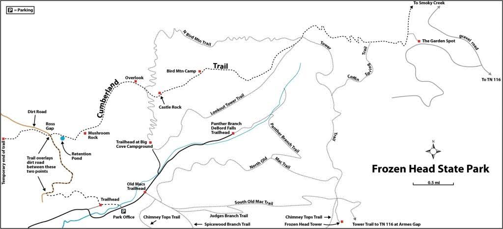
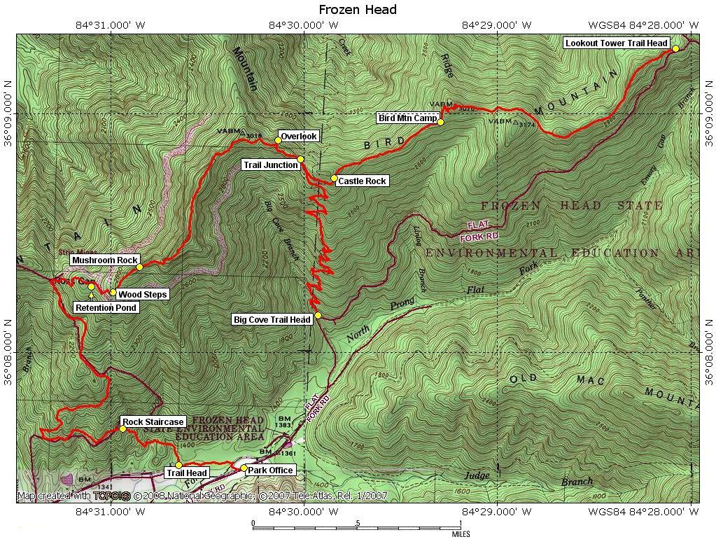
Map
Description
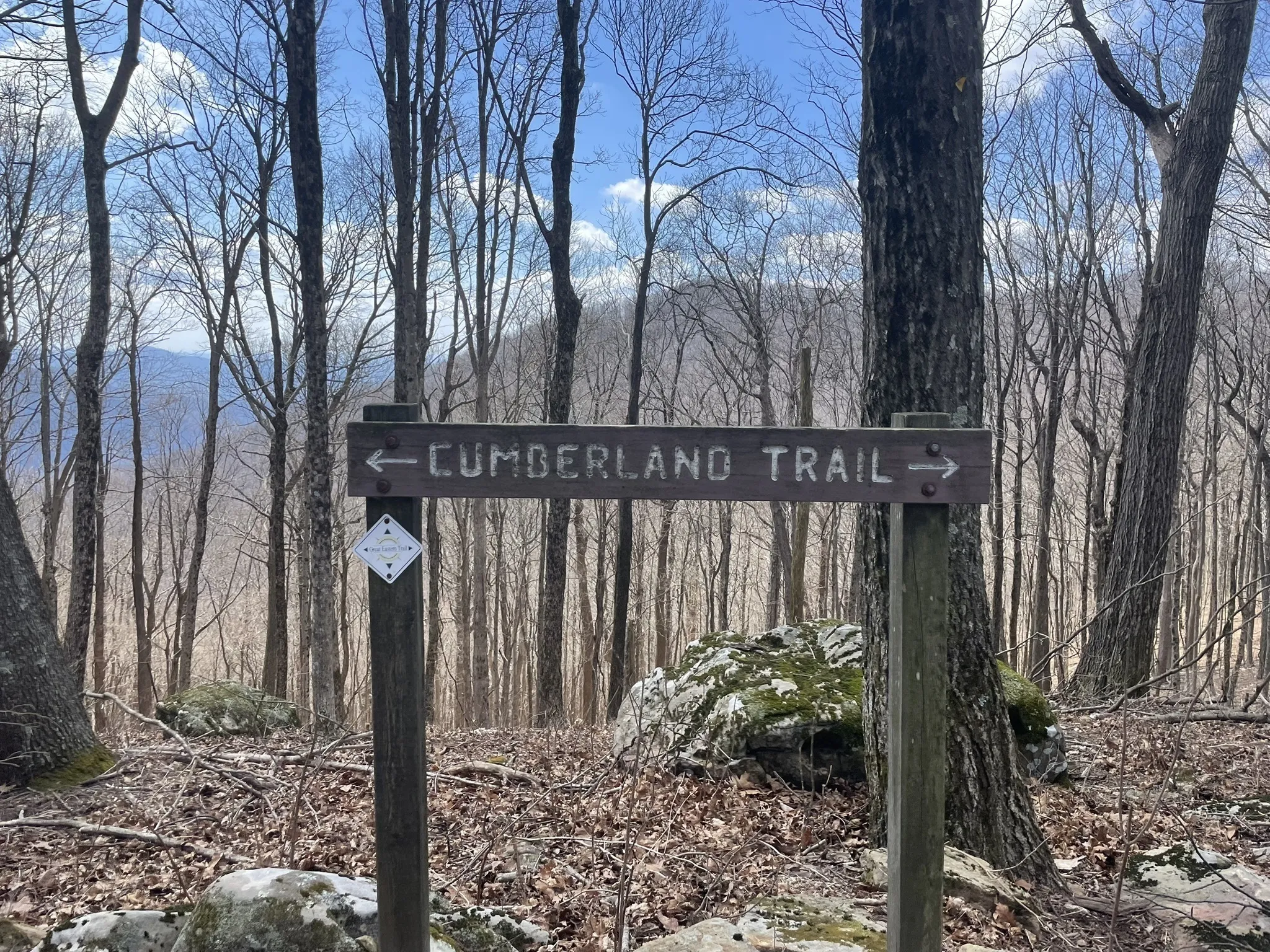
Mile 0.0 (7.9) The junction with the Cumberland Trail and Ross Gap Trail is at Ross Gap (N36 08.313 W84 31.314). Ross Gap is the easiest access point along the crest of Bird Mountain and thus is crossed by several roads and trails. With the roads over the crest, the Cumberland Trail, and some historic coal mine benches, Ross Gap is a fairly complicated spot.
At the junction, the CT to the left is the end of the Bird Mountain Section, with only 0.7 mile constructed at this writing. Turn right on the CT to begin the Frozen Head State Park Section, following a footpath along the south slope and then the ridge of Bird Mountain.
Mile 0.2 (7.7) Reach an old coal mine retention pond; this was a holding pond that was used as a source of water. Treat all water in the backcountry. At the far end of the pond, the trail enters a dense band of pines that mark the area of a coal bench that has been partly reclaimed. Just beyond the pond, the CT crosses an old coal road that drops to the left to intersect the England Mountain Coal Bench.
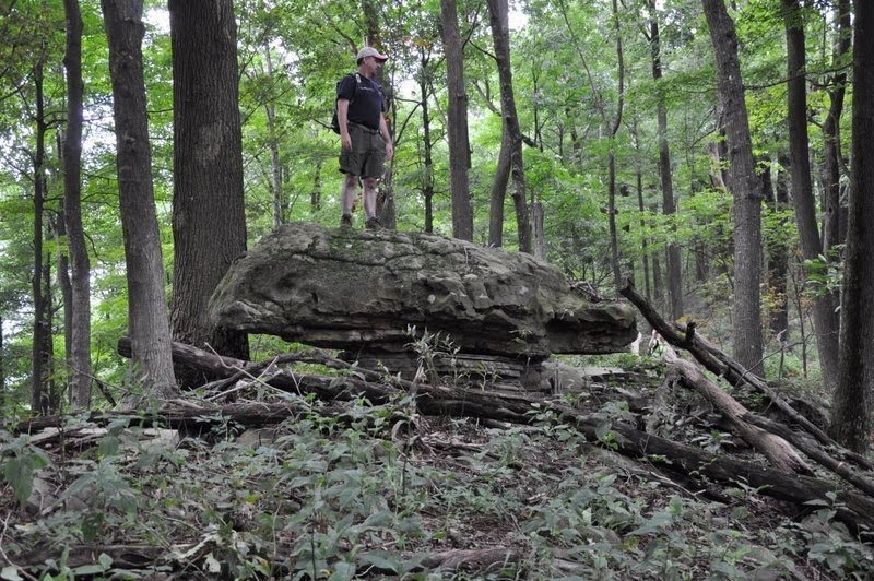
Mile 0.6 (7.3) Reach a large mushroom-shaped rock on the crest of Bird Mountain.
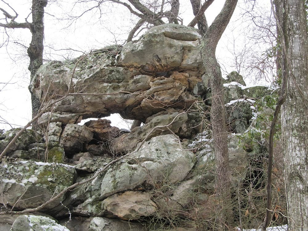
Mile 1.6 (6.3) At a point along the crest, the thick sandstone layer that forms the cap rock of Bird Mountain has been partly breached, leaving a set of pedestal steps that mark the beginning of a series of sheer sandstone bluffs. Here the trail traces the base of the cliff line on the south side of the long line of cap rock. At one bend to the north, there is a fine view into Emory River Valley to the north of Frozen Head. Keep a sharp eye out for a shapely arch high in the bluff that’s locally called “Castle Rocks West.”
Mile 1.9 (6.0) Reach a junction with FHSP’s North Bird Mountain Trail (N36 08.804 W84 30.019). At this junction, North Bird Mountain Trail branches left and descends into the Phillips Creek drainage before climbing three steep ridges to reconnect in 4.8 miles with the CT at Mile 4.7 in this description.
Just 50 feet beyond this trail junction, the park’s Bird Mountain Trail turns right down the steep slope of Bird Mountain to a trailhead at Big Cove Campground in 2.1 miles. The campground has modern bathrooms and hot showers and is open from March 15 to November 1.
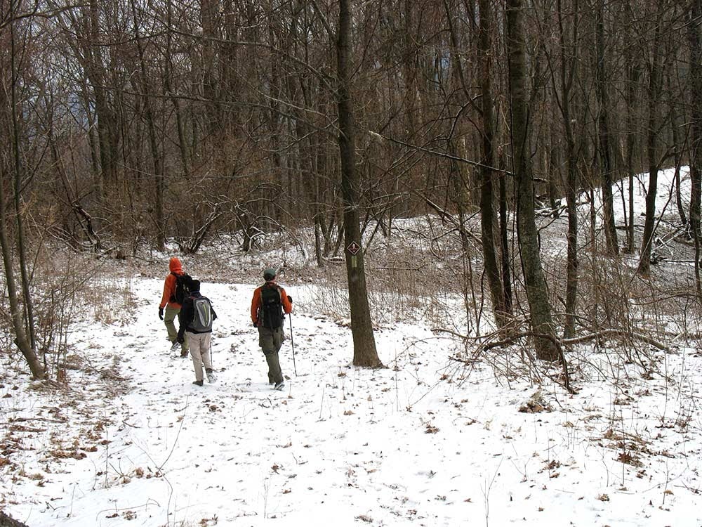
From this second junction, the CT follows Bird Mountain Trail east along the crest of the mountain. This section of the Bird Mountain Trail was built in 1988 by Tennessee State Parks after the former Morgan State Forest was transferred to the state park system. The crest of the mountain offers some of the finest walking in the Cumberlands. The ridge crest is high enough to catch cool breezes in summer, and in winter spectacular displays of rime ice often coat the trees.
The trail immediately traces the base of the main area of Castle Rocks, a long series of tall sandstone bluffs, then climbs to a signed highpoint.
Mile 2.9 (5.0) Reach the Bird Mountain Campsite (N36 08.964 W84 29.308) with tent sites and an intermittent spring on the south side of the trail.
Mile 3.3 (4.6) The foot trail ends where it becomes an abandoned road along the crest. The flat area at the next saddle marks the site of an old sawmill used in the pre-park era.
Mile 4.5 (3.4) Reach a signed junction with FHSP’s Tower Trail (aka the “Jeep Road”) (N36 09.250 W84 28.120). The Tower Trail leads right 3.0 miles down to the Big Cove Campground. The CT turns left to follow the road for a short distance.
Mile 4.6 (3.3) Reach a second signed junction with the North Bird Mountain Trail. Here the CT turns left on this trail to climb the slope of Bald Knob, while the Tower Trail continues right to reach the lookout tower on the summit of Frozen Head Mountain in 3.6 miles.
Mile 4.7 (3.2) At a junction, the CT turns right to now follow the orange-blazed North Boundary Trail. While in many places the Cumberland Trail is some of the newest foot trail in Tennessee, FHSP’s North Boundary Trail is some of the oldest. The Depression-era Civilian Conservation Corps (CCC) constructed the trail in the 1930s. The CCC was a jobs creation and infrastructure program that left a remarkable legacy in America’s parks. CCC crews built many of the roads, trails, and structures still heavily used in our state and national parks and forests. The North Boundary Trail was part of a system built by the CCC for rangers to patrol the boundaries of what was then Morgan State Forest. The trail was used until the 1970s when maintenance was stopped and the trail was effectively abandoned. In the early 2000s, park volunteers began reclearing the trail and first opened the section between Phillips Creek and Bald Knob that has since been renamed the North Bird Mountain Trail. In 2010, volunteers cleared the trail east to a series of coal ponds, which is now the route of the CT.
From this junction, the CT swings north, generally following the contour around the north slope of Bald Knob and shortly reaches the edge of an area logged in 2002 when the north slope of Bald Knob was not part of the park. The 2002-era logging was selective and the area has recovered well in the intervening years; however, the difference in the density of mature trees on the cut and uncut sides of the border is still visible.
As part of former-Governor Phil Bredesen’s Connecting the Cumberlands Initiative, the 8,000-acre Emory Tract was added to FHSP and Natural Area in 2007 and includes the north slope of Bald Knob. The Emory Tract includes most of the land between the former north boundary of the park and the Emory River to the north.
Mile 5.7 (2.2) After rounding the crest of Bald Knob, the trail drops to a small creek and then climbs to the crest of a slope on Squire Knob. Students from Iowa’s Wartburg College rebuilt much of this section of trail in 2009.
Mile 6.3 (1.6) After switchbacking down a remarkably steep slope, reach the small creek that drains from Coffin Spring and forms the headwater of the Emory River. Coffin Spring is one of the many ominous geographic names, along with Judge Branch and Jury Ridge, that result from FHSP’s proximity to both the former Brushy Mountain State Penitentiary on its east border and Morgan County Correctional Complex near its south entrance.
Just beyond the creek, the trail skirts a deep and sheer gash in the earth known as “Son of a Bitch Ditch.” The origin of the ditch continues to be a source of debate, but the presence of similar features carved into the steep slopes of the Frozen Head landscape indicates that localized torrential rainfalls that can drop several inches of rain in a small area in under an hour likely cause these ditches to form.
Mile 6.5 (1.4) Reach the western end of a series of coal ponds (N36 09.333 W84 26.991) and a junction with FHSP’s Coffin Spring Trail. Coal mining in the early 1970s that extended right up to the boundary of Frozen Head destroyed part of the old trail here. From the edge of the coal ponds, the CT and Coffin Spring trails follow an old roadbed to the right for a few feet, then turn left onto trail constructed by the FHSP volunteer trail crew in 2011.
Mile 6.7 (1.2) At a junction, the CT separates to the left with the Coffin Spring Trail continuing to the right. You can choose to loop back from here, following the Coffin Spring Trail to ascend to the spring in 0.4 mile and another 0.8 mile as an old roadbed to reach a junction with the Tower Trail. From that junction, several routes within the state park will return to your starting point. To continue on the CT, turn left off Coffin Spring Trail onto trail originally built by CTC crews in 2004 and 2005 and then reopened in 2011.
Mile 7.0 (0.9) At the base of a small set of steps, rejoin the route of the original North Boundary Trail. The trail passes above the coal ponds, crosses a small drainage, and climbs toward the Garden Spot on a series of long switchbacks.
Mile 7.7 (0.2) Join a rough dirt road below the Garden Spot. Here the CT leaves FHSP and the old North Boundary Trail and enters North Cumberland Wildlife Management Area. The trail traverses along the base of some cliffs that remain from high-wall coal mining.
Mile 7.9 (0.0) Reach an intersection with a gravel road near a gas well at the north end of the Garden Spot, which rather than being a “spot” is a large, flat summit. This intersection is a shady grove of pines that makes a great lunch spot and dry campsite. The gravel road to the right leads to an overlook that was opened by a high wall remaining from coal mining.
— Hiram Rogers, FHSP Volunteer Trail Crew Member and CTC Board Member
More Information
Barkley Marathon
The park’s old North Boundary Trail struck fear into the hearts of the “Barkers,” as the runners in the Barkley “marathon” are called. The Barkley gets its reputation as the world’s toughest foot race primarily from its astoundingly low finishing rate. In the 26-year history of the race, only 13 runners have managed to finish the demanding 100-mile course with a mind-boggling total 55,000 feet of climbing.
The Barkley, named for a friend of the race director, roughly circles the perimeter of FHSP on an unmarked course using a combination of trails ranging from well-maintained to long-abandoned to virtually imaginary. The combination of relentlessly steep climbing, briar-choked trails, difficult footing, and near impossible route-finding prove year after year to be too much for all but the most fit and mentally strong to cover the course in less than the allotted 60 hours.
In the early years of the race, it was the park’s old North Boundary Trail that was the most difficult. Decades of neglect left this trail an obstacle course of fallen trees, thick undergrowth, slippery side hills, and switchbacks to nowhere.
Cumberland Trail hikers, as well as the Barkers, appreciate the work done by the park staff and volunteers to re-open the North Boundary Trail, which the CT now follows from Bald Knob to the Garden Spot. —HR
FHSP History
The history of Frozen Head State Park is closely tied to neighboring Brushy Mountain State Prison and to the legacy of coal mining that has so devastated the Cumberland Mountains.
In the late 1800s, the State of Tennessee began leasing convicts to work in private coal mines to raise revenues for the State. The use of prisoners in the mines led to harsh conditions for both convict and free miners. The Coal Creek Wars of 1891-92 in nearby Briceville and Lake City, in which the free miners would set the prisoners free and the National Guard would be called in, ended the convict labor system.
The State immediately began construction on mines and a prison on a new 12,000-acre property at Brushy Mountain near the community of Petros. The prison coal mines at Brushy remained a revenue source for Tennessee until their closure in 1965.
The State transferred much of the original property to Morgan State Forest in 1933, and the newly formed Civilian Conservation Corps began building the park’s infrastructure, including much of the current trail system. Through the advocacy of local conservationists, especially Don Todd, a Morgan County school teacher and one of the founders of the CTC, the forestland was transferred to the state park system in 1970. Most of the area was declared a state natural area in 1988; the small developed area of playgrounds and visitor center along Flat Fork Road remain state park.
Neighboring Brushy Mountain State Prison was closed in 2009 when the remaining inmates were transferred to the Morgan County Correctional Complex in Flat Fork Valley.
Elk, bear, and boar
Logging, mining, and hunting pressure from homesteaders combined to eliminate many big game species from the Cumberland Mountains by the late 1800s. However, thanks to the efforts of conservationists, many species are making a return to these mountains.
Between 2000 and 2003, TWRA and the Rocky Mountain Elk Foundation partnered to return elk to the Cumberlands. The 137 elk from the Land Between the Lakes and Alberta’s Elk Island National Park that were transplanted to the North Cumberland Wildlife Management Area have flourished in their new home, and the elk population has risen to a level to allow a limited hunting season to begin in 2009.
Black bear also have been moving into the Cumberlands and have been spotted by rangers in Frozen Head. In 1996 and 1997, black bears from Great Smoky Mountains National Park were introduced to the Big South Fork National River and Recreation Area to the north. The NPS estimates that 40-50 bears now live in the Big South Fork.
One mammal that also unfortunately is becoming established in the area is wild boar. These non-native animals were first seen in the Gobey area in the middle 2000s. Boar reproduce rapidly and travel in small packs that can devastate plant populations as they plow through the soil looking for food. Wide swaths that look rototilled, and wallows along shallow springs are the most common signs of the presence of boar. TWRA and TN State Parks are currently working on plans for long-term control of the boar population. —HR
Frozen Head State Park Side Loops
Frozen Head State Park has the largest trail network of any area crossed by the Cumberland Trail and offers a number of exceptional loop hikes. Before venturing too far off the CT, hikers should print a map of the current trail system from the park’s website or buy a more detailed copy of the older park map from the Visitor Center.
Ross Gap-CT-Bird Mountain Loop
This loop combines the two designated access trails to the CT on the southwest end of the park. Start by following the short connector trail from the Rocky Fork Trailhead and then the Ross Gap Trail for 2.4 miles to Ross Gap and then the CT for 1.9 miles to the junction with the Bird Mountain Trail. Instead of continuing along the CT on the crest, turn right down the Bird Mountain Trail to reach the Tower Trail at 6.2 miles and a trailhead in the Big Cove Campground at 6.4 miles. Walk back down Flat Fork Road (or use the Flat Fork Walking Trail) to the Visitor Center at 7.2 miles. If water is high, continue on the road to complete the loop to the Rocky Fork Trailhead in 7.8 miles, or ford the creek at low water and follow the trail to return to the trailhead at 7.6 miles.
Bird Mountain-Tower Trail Loop
This loop leaves the Big Cove Campground Trailhead (use the parking area at the picnic shelter when the campground is closed in winter). Climb for 0.2 mile on the Tower Trail, then turn left on the Bird Mountain Trail. Climb a long series of switchbacks to reach the CT at 2.1 miles. Turn right on the CT and pass Castle Rocks and the Bird Mountain Campsite before reaching another junction with the Tower Trail at 4.7 miles. Turn right and walk down the Tower Trail to return to the campground trailhead at 7.7 miles.
Bird Mountain-North Bird Mountain-Tower Trail Loop
A much longer loop extends the Bird Mountain-Tower Trail Loop onto the North Bird Mountain Trail. Follow the directions above to reach the junction of the CT and Tower Trail at 4.7 miles. Instead of descending on the Tower Trail continue on the CT until it reaches the eastern edge of the coal ponds at 6.6 miles. From that junction, follow the old roadbed/Coffin Spring Trail to reach the park boundary at Coffin Spring at 7.4 miles. The spring is a reliable water source, well protected by a rock enclosure. Continue on the Coffin Spring Trail, which now follows a road occasionally used by park staff. At 8.2 miles, turn right onto the Tower Trail, which follows the mountain ridge. At 9.1 miles, reach a junction with a side trail to Squire Knob Campsite, which generally has no water. At 9.7 miles, reach the junction with the CT (at the 6.9 mile mark). Continue down the Tower Trail to reach Big Cove Campground at 12.7 miles. —HR
Frozen Head Topos and GPS Waypoints
The following detailed topographic map of the trail was created using TOPO! 2009 National Geographic found at National Geographic Topo Explorer.
| Location | GPS Waypoint |
|---|---|
| Big Cove Trailhead | N36 08.154 W84 29.930 |
| Bird Mtn Camp | N36 08.966 W84 29.294 |
| Castle Rock | N36 08.730 W84 29.843 |
| Lookout Tower Trail Trailhead | N36 09.273 W84 28.078 |
| Mushroom Rock | N36 08.358 W84 30.850 |
| North Bird Mtn Trail Junction | N36 08.808 W84 30.018 |
| Overlook | N36 08.880 W84 30.135 |
| Park Office | N36 07.515 W84 30.311 |
| Park Office Trailhead | N36 07.522 W84 30.645 |
| Retention Pond | N36 08.290 W84 31.085 |
| Rock Staircase | N36 07.679 W84 30.937 |