Pot Point Loop
Prentice Cooper State Forest Trailhead
Overview
The Tennessee River Gorge segment consists of two linear sections, Signal & Edwards Points and Poplar Springs. Mullens Cove and Pot Point are two loops that are featured in this segment as well. Together, these sections make up 33.8 miles of trail currently open, but only 6.9 miles of the Signal Point section are considered part of the official Cumberland Trail. The Poplar Springs trail connects the CT to the figure-eight of Mullens Cove and Pot Point loops.
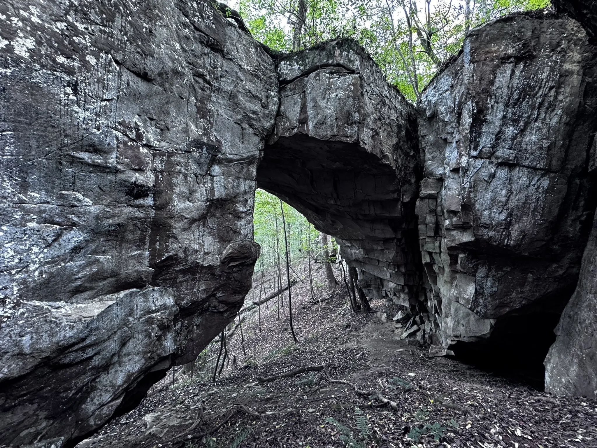
Highlights of Pot Point include spectacular, high overlooks of the Tennessee River Grofe and Nickajack Lake, and a natural bridge.
Trail Section Details
Features:
- Overlooks
- Fall color
- Loop/Lollipop
Counties:
- Marion
Distance:
11.7 miles
Difficulty:
Moderate
Elevation Change:
400 feet
Northern Terminus:
Tower Drive Eastside Trailhead
Southern Terminus:
Tower Drive Westside Trailhead
Timezone:
Central
Cautions:
Some rocky sections; rolling hills contribute to a cumulative elevation change of 1600 feet.
Camping:
McNabb Gulf Campsite at mile 8.2 (3.5 for counter-clockwise travel)
Seasonal Notes:
Periodic hunting closures (check Prentice Cooper State Forest website); turkey nesting; winter vehicle access
Water Sources:
Highly seasonal springs; not guaranteed
Trailheads
Two on Tower Drive, on the right (west) and left (east) sides of the road.
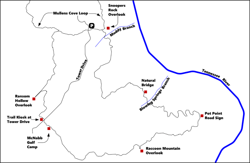
Map
Description
Mile 0.0 (9.8) Leave the parking area on the left of Tower Drive and head south for a few yards. One trailhead is on the right (west) side of the road. The other trailhead is on the left (east) side of Tower Drive. This section of the trail is shared with the Mullens Cove Loop. Follow the trail straight ahead. Very soon, an access trail/road from the parking area comes in from the left.
Mile 0.3 (11.4) The junction with Mullen Cove Loop departs to the left. Turn right to stay on Pot Point Loop. The trail turns southwest away from the gorge. Cross two wooden bridges at 1.9 and 2.0 miles, both over wet weather drains. The trail turns northeast back towards the gorge. Climb up to the rim at 2.7 miles, head southeast, and start seeing teaser views of the Tennessee River and Raccoon Mountain to the left. At 3.0 miles, reach a partially obstructed lookout to the left on a very large boulder.
Mile 3.1 (8.6) The trail crosses the Natural Bridge (N35 05.214, W85 24.787). This is an impressive bridge about 25 feet high and 35 feet wide. The scamper down to get below the bridge is steep, but certainly doable. The trail continues southeast, crosses seasonal Blowing Springs Branch, at 3.3 miles, then curves and generally heads east.
Mile 5.2 (6.5) The trail curves south and passes two wooden stobs at 5.1 miles at an overgrown roadbed, and then comes to a sign for Pot Point Road (N35 04.823, W85 23.782) at 5.2 miles. The road does not appear to cross the trail at the sign, rather a short way back at the two stobs. The trail now curves southwest. This portion of the trail has a view of the gorge on the left, and is exposed to the sun.
Mile 6.7 (5.0) Pass a “boulder garden” at 6.4 miles and reach a sign for Raccoon Mountain Overlook (N35 04.400, W85 24.836) at 6.7 miles. Take the short spur trail to the left for a partially obstructed view of Raccoon Mountain. Return to the main trail and reach a large double boulder at 7.3 miles. The trail curves northwest away from the gorge and starts descending into McNabb Gulf. Go past a large cantilevered boulder 8.2 miles.
Mile 8.5 (3.2) Start climbing out of the gulf and reach the sign for McNabb Gulf Camp (N35 4.439, W85 26.220) at 8.5 miles. The trail continues ascending northwest.
Mile 9.2 (2.5) Finish the climb out of the gulf and reach Tower Drive at 9.2 miles. The trail picks back up straight across the road at a kiosk (N35 04.795. W85 26.535) with a trail map. Continue on the trail and shortly turn northeast as the trail dips below the rim.
Mile 10.0 (1.7) The trail curves back northwest and comes to a sign (N35 05.201, W85 26.579) for the spur trail to Ransom Hollow Lookout at 10.0 miles. Take the spur trail miles to superlative overlook. The view of the Nickajack Lake and the Tennessee River Gorge is one of the best on the Cumberland Plateau. This is a great place for a long, well-deserved rest when doing the loop clockwise. Return to the main trail and continue northwest and soon due north.
Mile 11.3 (0.4) Descend to Hemlock Branch and reach a signed junction (N35 06.072, W85 26.281) with the Mullen Cove Loop trail at 11.3.
Mile 11.7 (0.0) Turn east and Hemlock Branch. Return to the trailhead at 11.7 miles.
Description and photos courtesy of Gary Stephens
More Information
Campsites
McNabb Gulf Campsite at mile 8.2 (N35 4.439, W85 26.220), or can be found 3.5 miles in if hiking in a counter-clockwise rotation.