Poplar Springs
Prentice Cooper State Forest TH to Suck Creek Rd (TN 27)
Overview
The Poplar Springs section of the Cumberland Trail was constructed over 35 years ago by Tennessee Division Forestry employees and is the oldest portion of the Cumberland Trail that has remained continually open. The Poplar Spring Section links the Signal & Edward Points Section of the Tennessee River Gorge Segment with the Mullens Cove Loop Trail in Prentice Cooper State Forest and Wildlife Management Area (WMA).
This section begins at the main trailhead for the Cumberland Trail in Prentice Cooper State Forest and ends at TN 27 as its northern terminus. TN 27, also known as Suck Creek Road because it parallels Suck Creek. There are also two loop trails that join this section in the Prentice Cooper State Forest totaling over 20 miles with several campsites, making this area very popular with backpackers and hunters.
Highlights of this section include overlooks of the Tennessee River, many unusual rock formations, rockhouses, and bluffs. In spring, expect abundant wildflowers, ferns, and woodland plants.
Trail Section Details
Features:
- Wildflowers
- Fall color
- Bluffs
Counties:
- Sequatchie
- /
- Hamilton
- /
- Marion
Distance:
4.9 miles
Difficulty:
Moderate
Elevation Change:
400 feet
Northern Terminus:
TN 27 (N35 09.172 W85 23.698)
Southern Terminus:
Prentice Cooper State Forest/WMA Cumberland Trail parking (N35 07.966 W85 25.165)
Timezone:
EDT
Cautions:
Steep, rocky bluffs, tricky footing, and high-water crossings after heavy rain
Camping:
Poplar Springs Campsite at Mile 3.3 (1.6)
Seasonal Notes:
Closed to hikers during big game hunting season in the spring and fall; check with check with the Tennessee Division of Forestry/Prentice Cooper State Forest website for closure dates and wear orange during any hunting season: http://www.tn.gov/agriculture/forestry/stateforest07.shtml
Water Sources:
Very reliable
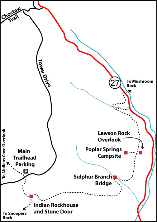
Trailheads
The main trailhead (N35 09.394 W085 23.943) is marked with signage and a wooden stairway at the highway and located 1.9 miles southeast from the turnoff into Prentice Cooper State Forest and 6.2 miles southeast from Powell’s Crossroads.
If coming from Chattanooga on US 127, turn left onto TN 27 (Suck Creek Road) and continue northwest for 6 miles.
Parking can be found on a paved pullout just before the trail crossing and stairway on TN 27. It is possible to park one high-clearance vehicle off the road at the stairway, but care must be taken as this is a limited-sight area on a heavily traveled mountainous road.
The other trailhead (N35 08.760 W85 08.832) is 0.6 mile down TN 27 from the stairway. A sign is there as well with parking at a gravel pullout within eyesight. This is a blue-blazed spur trail that connects to the white-blazed Cumberland Trail at 0.6 mile above the stairway. This access is part of the original section of the Cumberland Trail that had to be rerouted after flooding in Suck Creek in 1982.

The Southern Terminus of this Poplar Spring Section is at the main trailhead parking area in Prentice Cooper State Forest.
Continue northwest on TN 27 from the stairway.
In 1.9 miles, turn left at the sign for Prentice Cooper State Forest and WMA.
The mileage to the trailhead is 3.2 miles from this turn, but watch carefully for Prentice Cooper WMA signs, as there are two more turns. One is more of a bear left and happens almost immediately. The other is a left turn at 0.1 mile on Tower Drive, and continue to the parking area on the right at N35 07.966 W85 25.165.
This main trailhead for the state forest has a kiosk with information about the other trails within Prentice Cooper State Forest and is also the start and finish for the 9.8-mile Mullens Cove Loop.
Map
Description
Mile 0.0 (4.9) From the parking area on Tower Drive, cross the road to the east, coinciding with the Mullens Cove Loop.
Mile 0.3 (4.6) Cross an old road as the trail descends.
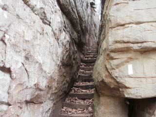
Mile 0.5 (4.4) Reach the top of a rock bluff with nice views of the trail below. Descend through a “stone door” (N35 07.683, W85 25.134) on rock steps that have been built in the crevice and reach a junction with the Mullens Cove Loop turning to the right headed toward Snooper’s Rock. Turn left to stay on the CT.
The trail hugs the rock bluff, leading to Indian Rock House, an archaeological site where many artifacts have been found. This once provided shelter for the Cherokee Indians and was probably used as a hunting camp. No digging is permitted.
Mile 0.9 (4.0) The trail leads to a large rock bluff on the left that has a two-story rockhouse up high—two openings, one on top of the other. Soon after, the trail approaches the escarpment above the Tennessee River.
Mile 1.4 (3.5) The trail leads past a clearcut down the mountain that was for a buried gas pipeline and then takes you to a rock overhang.
Mile 2.2 (2.7) To your right are three interesting stacked rock formations or chimney rocks that are best visible in winter. You’ll have several wet-weather stream crossings as the trail continues in a rollercoaster fashion. The trail affords a nice view of the Tennessee River below as it bears left away from the escarpment.
Mile 2.5 (2.4) Cross more wet-weather streams that will likely be dry in the summer months and arrive at the Sulphur Branch Bridge (N35 07.971, W85 23.847). Look for wildflowers here and listen for the sound of a 20-foot waterfall after a recent rain. The waterfall is to the left before crossing the bridge at about 100 yards but will require some bushwacking to get to. After crossing the creek, you’ll ascend many rock steps.
Mile 3.2 (1.7) Continue over rocks through a forest of red in the Fall and good winter views to the right. The trail ascends rock steps between huge boulders that give the hiker shelter in sudden rain showers. This second “stone door” is smaller than the one you encountered first. At the top, turn right. You will come to an area of blowdowns and dead pines, probably caused by pine beetle infestation.
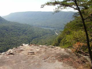
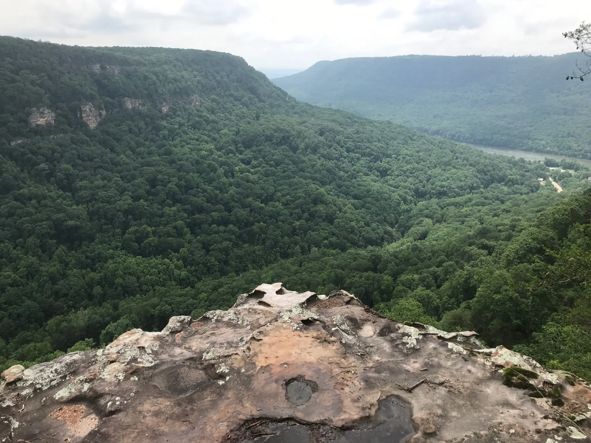
Mile 3.3 (1.6) On the right is Lawson Rock Overlook and to the left is a trail leading to Poplar Springs Campsite. From the overlook, you have a great view of the Tennessee River and TN 27 below. The spur trail on the left is blue blazed and leads about 900 feet, crossing a jeep road, to the campsite. The water source is potable but should be treated or filtered before drinking. The spring is located about 300 feet from the campsite at the base of a large poplar tree, for which the spring and campsite are named. There is a sign on a tree at the campsite pointing toward the spring, and on the poplar at the spring as well. On the main trail, continue following the white-blazed CT.
Mile 3.7 (1.2) At 1,700 feet, you’ll have a good view of Suck Creek Gorge; in spring, look for large jack-in-the-pulpits growing under the bluffs along the way. The trail then descends.
Mile 3.9 (1.0) From a nice overlook of the trail below, the trail descends rock steps and then a set of wooden steps. Make several more stream crossings and pass rhododendron (Rhododendron catawbiense) that blooms purple here in late spring, a full month earlier than the same species on Roan Mountain in northeast Tennessee. The trail descends and passes a huge flat sloping rock then hugs a rock bluff on your left. Notice a large rock outcropping on your left with a large sink hole to the right among ferns.
Mile 4.3 (0.6) Continue on the main trail following the white blazes. The trail begins to descend with many ups and downs and wet-weather stream crossings. There will be a sign on the right and an intersection with the blue-blazed spur trail on the right that leads 0.4 mile to TN 27 at the lower trailhead (see northern terminus description). This spur trail is quite rocky but worth the effort if you like to explore; in wet weather, you’ll hike beside a creek with a 10-foot waterfall and another nice cascade on your left about 100 yards off the trail.
Mile 4.6 (0.3) Another stream crossing will be dry in summer but tricky in wet weather.
Mile 4.7 (0.2) Continue descending to a final wet-weather stream crossing; the trail becomes soft tread in a pine forest. You’ll begin to hear road noise as you approach TN 27.
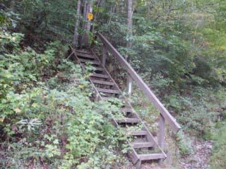
Mile 4.9 (0.0) The trail descends some rock steps that required a lot of hard work to build and finally descends stairs to the highway.
More Information
Campsites
Poplar Springs Campsite is found 3.3 miles into the section. From the overlook, you have a great view of the Tennessee River and TN 27 below. This overlook is named for Andrew Lawson, an early forest ranger in Prentice Cooper State Forest when this trail was built around 1974.
Details
- Suck Creek got its unusual name because where it flows into the Tennessee River, it once caused rapids and whirlpools that were said to suck in boats before a dam on the river submerged the rapids.
- The State Forest was named for Prentice Cooper, governor of Tennessee from 1939 to 1945, who was instrumental in preserving this 24,686-acre forest of chestnut oaks, white oaks, and shortleaf pines in 1945.
- Lawson Rock Overlook is named for Andrew Lawson, an early forest ranger in Prentice Cooper State Forest when this trail was built around 1974. The Lawson Family lived in this area in the late 1800s and early 1900s, and several of the family, including Andrew, are buried in the Lusk Cemetery on Tower Drive, a few miles down from the main trailhead in Prentice Cooper.
- Springtime flora consists of ferns, holly, woodland bluets, halberd-leaved violets, pussy-toes, lady slippers, rue anemone, and jack-in-the-pulpit.
- While this hike description ends here at road access, the Poplar Springs Section will continue to the east and junction with the Signal & Edwards Points Section in another 1.4 miles at the North Suck Creek suspension bridge and campsite. There the two trails will merge and continue north once a route to US 127 has been designated and constructed for the North Suck Creek Section.