Ozone Falls
Ozone Falls to Black Mountain
Overview
Ozone Falls, the northern terminus of this section, is easily accessible via a short hike from the Ozone Falls State Natural Area trailhead off US 70. This description, however, follows the more strenuous Cumberland Trail route traveling northbound from Black Mountain to the falls, with mileages measured from the Black Mountain trailhead kiosk. Though it descends about 1,323 feet and can be completed in 4–6 hours, the 6.7-mile route remains challenging with repeated steep climbs through the gorges of The Basin, Long Branch, and Falls Creek.
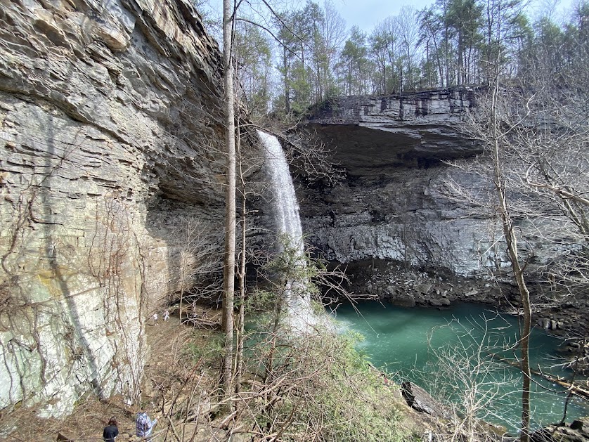
Along the way, hikers encounter sandstone bluffs, clear streams, rich forests, seasonal wildflowers, and exposed cap rock formed roughly 300 million years ago. The route culminates at the 110-foot Ozone Falls, which plunges into a large amphitheater and was featured in the 2016 live-action The Jungle Book. The final climb to the road follows stonework completed in 2020. Originally called McNair Falls in the 1860s, the site was later renamed for the area’s fresh, mist-filled air, and is now protected within the Ozone Falls State Natural Area, established in 1973 and expanded in 1996.
Trail Section Details
Features:
- Waterfalls
- Overlooks
- Swimming
- Wildflowers
- Fall color
- Bluffs
Counties:
- Cumberland
Distance:
6.7 miles
Difficulty:
Strenuous
Elevation Change:
Max EL 2730; Min EL 1407; Total Gain 976; Total Loss 2069
Northern Terminus:
Ozone Falls SNA Trailhead
Southern Terminus:
Black Mountain Trailhead
Timezone:
CDT
Cautions:
Portions of this section run through a narrow corridor alongside hunting preserves. Signs noting the hunting preserve boundaries are posted on trees along the way. Be aware of these boundaries during hunting season and wear blaze orange as an extra safety precaution.
Camping:
No designated campsites along this section.
Water Sources:
North Fork Basin Creek and Long Branch
Topographic Maps:
USGS US Topo 7.5-minute maps for Grassy Cove Quadrangle, Roddy Quadrangle and Ozone Quadrangle
Trailheads
Black Mountain Trailhead: N35 52.0497 W84 53.3282
Ozone Falls Trailhead: N35 52.8833 W84 48.3666
Trailhead Parking
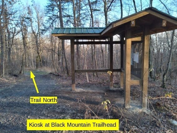
Black Mountain Trailhead: From I 40 Exit 329, take Bat Town Rd to the Cumberland Trail State Park sign at the intersection of three roads. Turn sharp left and proceed 3 miles up the narrow and steep paved Black Mountain Road to the paved trail head parking area on the right in front of the cell tower. There is ample room for several vehicles to park. Do not block the entrance to the cell tower area. Take the paved connector trail on the west side of the parking area for 500 feet to its connection with the Cumberland Trail. Look slightly uphill to the right to see the kiosk. All measurements in this guide are taken from the trailhead kiosk.
Alternately, from the parking area, there is a short path straight downhill to the trail. If you take this shortcut, turn left on the trail to begin (end) your hike at .1 (6.6) mile.
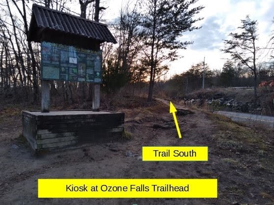
US Hwy 70 at Ozone Falls Trailhead: From the West, take I 40 Exit 329 to US 70. Take US 70 East to the Ozone Falls SNA parking area on the right beside US 70. There is a sign as you approach stating “Ozone Falls SNA 1500 feet”. From the East, take I 40 Exit 338 onto Westel Road. Follow Westel Rd. south to US 70. Turn right onto US 70 to Ozone Falls SNA parking. There is also a sign from this approach stating “Ozone Falls SNA 1500 feet”. There is parking room for 6 or 8 vehicles right beside US 70. There is unofficial parking across the highway near the railroad trestle. Use caution crossing this busy highway.
The kiosk is immediately in front of the parking area. From there, take the path to the right that parallels US 70 for about 200 feet, then begin the descent into the gorge at the bottom of the falls.
Description
Mile 0.0 ( 6.7) Kiosk – Section Begin (End).
Northbound: From the kiosk, proceed downhill on the gravelly path approximately 70 ft. The main trail bears right into the woods. Note that at this point, the trail runs concurrently with the Black Mountain Nature Loop blazed in yellow so the trail is blazed with both yellow and white blazes.
Southbound: As you approach the kiosk at section end, you can turn right onto a paved path for about 500 feet to the parking area or you can leave the kiosk on the left and continue in the trail south direction toward TN Hwy 68.
Mile 0.1 (6.6) Shortcut to the Parking Lot. On the left (right) there is a short path up to the parking lot. The main CT continues straight ahead.
Mile 0.3 (6.4) Main Trail Leaves (Joins) the Nature Trail. The trail branches here with the Nature Loop to the left (right) and the main CT to the right (left). Keep right (left).
Mile 0.4 (6.3) Sandstone Cap Rock Underfoot. The trail passes over and between sandstone cap rock. In springtime, watch for pink moccasin flowers, aka pink lady slippers, along the trail.
Mile .5 (6.2) Rock Outcropping and Sandstone Rock Garden. Notice the rock outcropping on the right (left) as you pass through a sandstone rock garden.
Mile .6 (6.1) Steep Descent (Ascent). Switch back left (right). Rock bluffs on the right (left) with large colonies of Rock Tripe (umbilicaria mammulata) lichen.
Mile .7 (6.0) Fern Colonies. Switch back left (right) then shortly switch back right (left) through cinnamon and bracken fern colonies. These will be lush in spring and summer. The brownish remnants are visible in winter.
Mile .8 (5.9) Sandy Creek Drainage. The bottom of the Sandy Creek drainage.
Mile .9 (5.8) Stone Steps. Descend (ascend) stone steps.
Mile 1.0 (5.7) Old Road. Cross an old road. Begin the descent into (end the ascent from) Owl Roost Gap.
Mile 1.2 (5.5) Drainage.
Mile 1.3 (5.4) Confusing Road Junction. North bound hikers: Cross an old logging road and up stone steps to a second ATV track. Note the orange stake boundary marker on the left. Turn right on this track for about 150 feet to the intersection of ATV roads. Look left uphill to see immediately on the left the trail reentering the forest. There is a white blaze marking the trail at this point. Shortly switch back right and then shortly cross another old road.
South Bound hikers: The trail emerges onto a junction of ATV roads. Turn right for about 150 feet. Then turn left down stone steps to a second old road. Note the orange stake boundary marker on the right. Cross the road and continue straight ahead.
Mile 1.5 (5.2) Two Drainages. Cross a drainage and 3 stone steps and then another drainage on stone steps.
Mile 1.6 (5.1) Stone Steps with Switchbacks. Continue through 2 switchbacks on stone steps before (after) crossing an old road remnant 200 feet ahead (behind).
Mile 1.8 (4.9) Cross an old road. You are just below the top of Haley Mountain. Pass a pond on the left (right) as you descend into (ascend out of) The Basin. This beautiful gorge is formed by the North Fork of Basin Creek. Hence the name The Basin.
Mile 2.0 (4.7) Double switchbacks. Continue to descend (ascend) steeply.
Mile 2.1 (4.6) Small Stream. A small steam feeds into North Fork Basin Creek and the beautiful spot called The Basin. Descend (ascend) gently through mountain laurel with the stream on the right.
Mile 2.2 (4.5) The Basin. Northbound – The trail descends (ascends) very steeply here. Stone steps and a natural rock formation present a treacherous passage. There are no handholds. Use extreme caution. Water tumbles over rock beneath a rock bluff on the right (left). Continue to cautiously descend (ascend) a long stone staircase into (out of) the Basin Creek gorge at The Basin.
Southbound – After crossing the creek, the trail ascends a long stone staircase with a rock bluff ahead and on the left. Water tumbles over rock beneath the bluff. Use caution climbing up a natural rock formation and then stone steps.
Mile 2.3 (4.4) North Fork Basin Creek. Cross the creek on stones using caution.
Mile 2.5 (4.2) Stone Steps with Switchback. 6 stone steps.
Mile 2.6 (4.1) Two Drainages. About 200 feet apart.
Mile 2.7 (4.0) Switchbacks. Switch back left (right) then right (left).
Mile 2.9 (3.8) Old Road. Cross an old road following white blazes and a brown diamond CT blaze directly ahead.
Mile 3.0 (3.7) Old Road for 75 Feet. Turn right at an old road then exit left.
Mile 3.3 (3.4) Old Road. Merge right onto an old road for a short distance and then exit to the left following white blazes.
Mile 3.4 (3.3) Long Branch Gorge. Begin descent (ascent) through several switchbacks.
Mile 3.5 (3.2) Old Road Bed. Descend (ascend) on an old road bed before bearing right (left).
Mile 3.6 (3.1) Switchbacks. Descend (ascend) through 2 switchbacks.
Mile 3.7 (3.0) Long Branch, EL1,819. Ascend (descend) an old road bed.
Mile 3.8 (2.9) Small Creek. Bear right (left) away from (onto) a road bed. Cross a small creek.
Mile 3.9 (2.8) Clear Cut. On the right (left) through the trees, continue to see an extensive area of private land that has been clear cut of timber in 2020.
Mile 4.2 (2.5) Wet Weather Drainage. The trail turns sharply left (right) and then descends (ascends) sharply for about 25 feet before (after) crossing a wet weather drainage.
Mile 4.3 (2.4) Old Road. The trail continues through deciduous third growth forest with Renegade Resort development unseen on the left (right) and the clear cut land on the right (left). Encounter an old road and bear right for a short distance and then exit to the left.
Mile 4.9 (1.8) White Pines and Cap Rock. For the next .5 mile the trail winds through an area with white pine trees beginning to insert into the deciduous forest. Also notice that much of the trail tread is on sandstone cap rock through this section.
Mile 5.5 (1.2) Falls Creek Gorge. Begin descent into (End ascent out of) the Falls Creek gorge.
Mile 5.6 (1.1) Sandstone Bluffs. As you descend (ascend) there are impressive sandstone bluffs to the left (right). The bluff exposes the various layers of sandstone laid down about 300 million years ago. Continue to follow the beautiful sandstone bluff on the left (right) using caution as you ascend (descend) a steep stone staircase.
Mile 5.9 (0.8) Stone Staircase. Stone staircase with 2 switchbacks.
Mile 6.0 (0.7) Fall Branch. Cross Fall Branch The trail utilizes an old roadbed for a short distance between Fall Branch and the aluminum bridge across Berks Creek.
Mile 6.1 (0.6) Aluminum Bridge. Cross an aluminum “Cumberland Trail Bridge” over Berks Creek near the confluence with Falls Creek. Bear Left after crossing the bridge. This area is also known as Renfro Hollow. Coordinates: 35 52.632N 84 48.855.
Mile 6.3 (0.4) Gully. Encounter a deep wash cut by drainage from US 70 above on the left (right). Until there is a bridge across this gully, climb down and up out of the wash on stones. Use caution here. Continue for .1 mile on mostly dirt tread with occasional stone steps and pavers.
Mile 6.5 (0.2) Section End (Begin). Use caution.
North Bound: Pause for pictures as you approach the falls; rest and enjoy the scene before making the final assault up to US 70 and the trailhead parking area. Turn left and begin the 100 feet ascent to US 70 above. At the highway, turn immediate right and climb stone steps to the path leading parallel to the highway toward the parking area and trailhead kiosk at EL 1,616 feet.
South Bound: From the kiosk, turn right and follow a path parallel to US 70 to stone steps down to the highway level. Turn left and begin the 100 feet descent into Falls Creek Gorge on stone steps.
— Frank Jamison, CTC Board Member