Lower Piney
Newby Branch to Shut in Gap Road
Overview
This segment of the Cumberland Trail, historically known as the “Piney River Trail,” was originally developed by the Hiwassee Land Company of Bowater Southern Paper Corporation before being deeded to the State of Tennessee. Although the Cumberland Trail remains incomplete between the Piney River area and the Laurel-Snow State Natural Area section to the south, recent progress has added the Upper Piney River Section, extending the trail roughly 9 additional miles beyond the point where the Lower Piney River trail leaves the river corridor toward Newby Branch. However, this newer section does not yet fully connect to the Lower Piney River route.
**Important Access Update:** The Newby Branch trailhead is no longer accessible due to private property restrictions. Hikers should plan to begin and end their trips at the Shut-In Gap Road (Piney River) trailhead and complete this segment as an out-and-back hike.
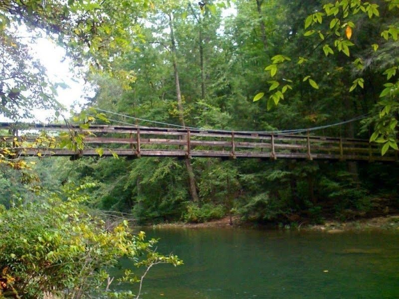
Marked with signage and white blazes, the Lower Piney River Section passes through dense mountain laurel, rhododendron, hemlock, and hardwood forest rich with native East Tennessee tree species, including large beech trees, pawpaw groves, and broad-leaf magnolias. Along the route, hikers encounter waterfalls, cascades, rock houses, bluffs, spur trails, an abandoned mine, remnants of a narrow-gauge railroad, multiple stream crossings, and a 100-foot suspension bridge spanning the Piney River, all providing abundant scenic and photographic opportunities.
Spring is especially notable for its exceptional wildflower displays, including trout lily, trillium, lady slippers, wild iris, Solomon’s seal, and many others, with March and April offering the best opportunities to experience the full range of blooms.
Trail Section Details
Features:
- Waterfalls
- Overlooks
- Swimming
- Wildflowers
- Fall color
- Bluffs
Distance:
8.5 miles
Difficulty:
Moderate
Elevation Change:
From the Newby Branch trailhead to the Shut In Gap Road trailhead there is a 772 feet loss South to North; 772 feet gain North to South
Northern Terminus:
Shut In Gap Road (N35 42.841 W84 52.837)
Southern Terminus:
Newby Branch Trailhead is permanently closed to public access due to private property restrictions. Hikers must begin and end their trip at Shut-In Gap Road trailhead. Plan hikes as out-and-back trips accordingly.
Timezone:
CDT
Cautions:
Steep drop-offs occur in places all along the trail. In winter, rocky overhangs have ice flows and hanging ice which can loosen during warming spells. If over night camping in the flats along the Piney River, be aware of weather conditions. Heavy rainfall often causes serious flash floods along the river. Areas that appear to be excellent for over night camping can be inundated quickly. The crossing of McDonald Branch at 6.6 miles South to North is treacherous.
Camping:
Rockhouse Branch Campsite (also called “Logging Camp Campsite”) at Mile 4.1 (4.4) as of 2015 is an authorized camp site. This segment guide identifies for clarity other campsites that are unofficial, however this does not grant the camper permission to use these campsites. Over night campers must register their intent by calling 423-566-2229 or by completing the registration form at http://www.friendsofthecumberlandtrail.org/camping/
Water Sources:
All water obtained in the back country should be treated before drinking. Bring your own water. Boil or sterilize water used for cooking.
Topographic Maps:
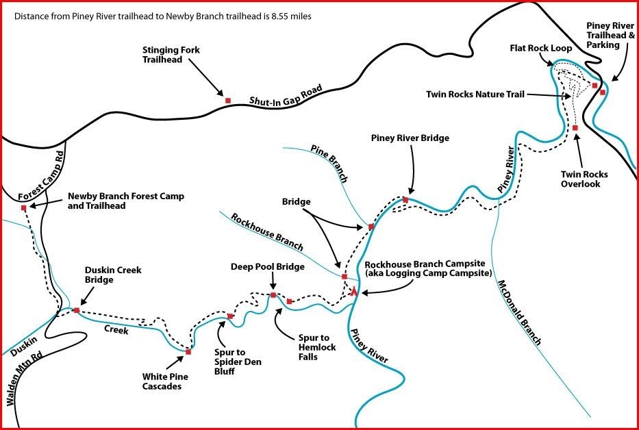
USGS Map Name: Pennine, TN, Map MRC: 35084F8; often simply referred to as the USGS Pennine Quadrangle Duskin Creek confluence with the Piney River. The trail from the Newby Branch trailhead to the Duskin Creek confluence is actually a spur section of trail that is maintained and provides an excellent access to the main CT. Refer to the overview of this section.
Trailheads
Both ends of this segment are accessible on Shut-In Gap Road. From US 27 at Spring City, take TN 68 northeast for 1.2 miles and turn left onto Shut-In Gap Road. Proceed another 1.1 miles to the large, well-kept Piney River Picnic Area on the right, which has ample parking. The Piney River Trailhead is on the left across the road from the picnic area. This trailhead is the northern terminus of the Piney River Segment and will be the southern terminus of The Falls Segment when constructed.
The Newby Branch Trailhead is permanently closed because Forest Camp Road is now private property. The landowner does not permit parking or pedestrian access. Hikers must access this segment from Shut-In Gap Road.
Map
Description
This section is described from North to South in keeping with this online guide’s directional standard of “South to North except when there is no Southern terminus in which case the description is written North to South.” As of the most recent update, there is no Southern terminus to the main trail which ends at Duskin Creek. The remaining trail leading up Duskin Creek to the Newby Branch trailhead is a spur trail.
See Piney River Topological Map and GPS Waypoints below.
Mile 0.0 (8.5) Piney River trailhead kiosk at Shut In Gap Road. There is a large well-kept picnic and parking area just across Shut In Gap Road from the trailhead. Hikers can station a vehicle here and another one at the Newby Branch picnic area off Forest Camp Road or at the trailhead on Walden Mountain Road and ferry back to pick up the other vehicle.
Mile 0.1 (8.4) Spur trail to Twin Rocks Overlook. This is one of two spur trails which together constitute a loop to Twin Rocks Overlook. The trail passes the second spur in another .3 mile. The hiker can leave the main trail here and hike to the overlook (Overlook ladder and decking are in disrepair, unsafe and are closed by CTSST) and then follow the second spur trail to where it rejoins the main trail at mile .4 (8.1).
Mile 0.3 (8.2) The Flat Rock Loop spur on the right makes a loop that rejoins the main trail at mile .5 from the segment end at Shut In Gap Road. Flat rock Loop has a picnic area beside the river. There is a trail that leads from that picnic area out to Shut In Gap Road about .1 mile above the Shut In Gap picnic and parking area or the hiker can continue on the loop back up the ridge to the main trail.
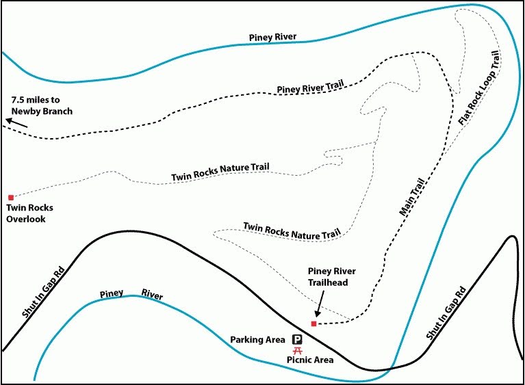
Mile 0.36 (8.14) The Flat Rock Loop rejoins the main trail on the right.
Mile 0.4 (8.1) Spur trail to Twin Rocks Overlook. This is one of two spur trails which together constitute a loop to Twin Rocks Overlook. The trail passes the second spur in another .3 mile. The North to South hiker can leave the main trail here and hike to the overlook (Overlook ladder and decking are in disrepair, unsafe and are closed by CTSST.) and then follow the second spur trail to where it rejoins the main trail at .1 mile from the segment end at Shut In Gap Road.
The main trail continues along the ridge line with the river below on the right for another .1 mile where the Flat Rock Loop spur trail rejoins the main trail .
Mile 1.9 (6.6) McDonald Branch. Caution! While this creek is mainly a wet-weather tributary, it tumbles steeply from high on the ridge down to the river below. Consequently, many rocks and boulders have been exposed in its bed. There is usually enough water in this creek to keep the rocks slippery. There is no bridge or easy ford of this creek, so use care while climbing from boulder to boulder.
The trail is fairly level, but the drop-off to the river below is steep in places. There’s an abundance of wildflowers on this stretch in the spring, lady slippers and many others are in bloom. The trail makes a descent of about 300 feet in less than 0.3 mile to the river bridge.
Mile 3.0 (5.5) The Piney River Suspension Bridge provides photographic opportunities of the river. The bridge parts were flown in by helicopter and assembled by the Bowater Paper Company so as not to damage the environment. The views are lovely from the bridge in both directions. Deep pools afford swimming and fishing opportunities. Just across the bridge is a very nice flat camping area with stone fireplaces and logs and stone seats. Be aware of weather conditions when camping near the Piney River. It is prone to flash flooding during heavy downpours. More than one life has been lost in flash floods along its banks.
After crossing the bridge, the trail continues upstream on an old narrow gauge railbed that remains from the coal and lumbering era.
Mile 3.1 (5.4) Rock Slide. A huge rock slide has inundated a portion of the main trail at mile 5.4 just before the suspension bridge across the Piney River. It is an impressive sight as you come down the trail and look ahead at a massive wall of rock 15 feet high across the abandoned narrow gauge railroad bed. The slide occurred in 2011 after heavy rains and created a wall of rock 15 feet high across the trail. Use caution as you scale this obstruction and descend on the other side.
Mile 3.4 (5.1) Pine Branch Bridge. The trail crosses Pine Branch Bridge and a short spur leads to Pine Branch falls.
Mile 4.1 (4.4) Rockhouse Branch. There is a spur that leads to the right up Rockhouse Branch to a nice rock shelter.
The trail turns upstream for a short distance along Rockhouse Branch, another tributary of Piney River, and passes an impressive old stone construction on the left. It’s made of stacked stone and looks like a pier extending toward the creek. It was used by the old narrow gauge railroad as an abutment for a bridge across the creek. On the other side, there is evidence of an abutment and a railbed though it is hard to see beyond the trees.
Cross the 40-foot Rockhouse Branch Bridge; a side trail left drops down the ridge to the Rockhouse Branch Campsite (also called “Logging Camp Campsite”) not far from the confluence of Duskin Creek with the Piney River.
From the campsite, this side trail climbs back up the ridge and rejoins the main trail, a loop route of 0.1 mile.
Note: “Rockhouse Branch Campsite (also called “Logging Camp Campsite”) at Mile 4.1 (4.4) as of 2015 is an authorized camp site. This segment guide identifies for clarity other campsites that are unofficial; however, this does not grant the camper permission to use these campsites. Overnight campers must register their intent by calling 423-566-2229 or by completing the registration form at http://www.friendsofthecumberlandtrail.org/camping/.
After the Rockhouse Branch Bridge crossing and the side trail, the main trail turns back down toward the river, and in 300 feet you’ll reach the junction where the short loop comes back in on the left. In another 50 feet, the trail rejoins the old railbed along the river. The trail bears right to now follow Duskin Creek upstream. This is the approximate end of the main trail and the beginning of the 3.7 mile spur trail leading to the Newby trailhead.
Mile 4.3 (4.2) A spur leads a short distance to a rock shelter.
Mile 4.6 (3.9) Spur to Hemlock Falls. A short spur trail leads to to the right to Hemlock Falls, which is actually a small cascade. The trail leaves the old road bed and descends the ridge gradually.
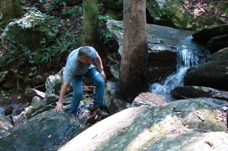
Mile 4.8 (3.7) Deep Pool Cascade and Deep Pool Cascade Bridge. This pretty little cascade falls 4 or 5 feet over several rock ledges into a deep blue-green pool of water. From the Deep Pool Cascades steel bridge, there is a good view. There is no direct spur trail down to the cascade so use caution if you decide to cool your feet in the water.
For the next half mile, the trail follows the ridge above Duskin Creek with nice views of the opposite ridges before descending down to Duskin Creek again.
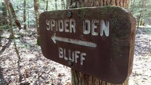
Mile 5.4 (3.1) Spider Den Bluff Spur Trail. A wooden sign with Spider Den Bluff in white letters at trail side marks this side trail which descends steeply for .3 mile to the banks of Duskin Creek. At the base of Spider Den Bluff, walk downstream to a fine campsite with rock table and benches. The campsite is fine for either a lunch break or over night camping. However, if you take the spur to Spider Den Bluff, you must back track to the main trail to continue.
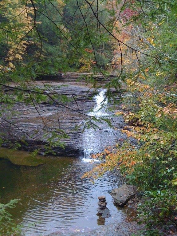
Mile 5.9 (2.6) White Pine Cascades. A wooden sign marks this lovely feature. Perhaps the most unusual aspect of White Pine Cascades is that there are almost no white pines in the vicinity; perhaps there were when the cascade was named. The cascade offers fine photo opportunities in all seasons, but especially in fall when the deciduous forest colors make for a spectacular backdrop. In winter, ice sheets may form large shelves, and during the spring rainy season, the cascade roars with the large volume of water passing over. In summer dry season, the cascade may become a trickle.
The trail switchbacks up from Duskin Creek and continues along the side of a ridge about 100 feet above the creek. The trail is lined with stone slab; use caution, especially in wet or icy conditions.
Mile 6.4 (2.1) Campsite. The trail cuts through a good over night campsite and continues for the next 1.2 miles through lovely mixed hardwood, some dense mountain laurel and rhododendron thickets and hemlock forest.
An old mine once existed to the right along this portion of the trail. Not much can be seen today except for some rubble piles. A sign marked the site at one time, but no longer exists. There are two mine openings and some concrete construction remnants that still exist on the ridge above the trail.
CAUTION: DO NOT ATTEMPT TO ENTER EITHER OF THE OPENINGS. THE SOIL AND ROCK IN THIS VICINITY IS EXTREMELY UNSTABLE.
Further, the State of Tennessee has instituted a policy of closing all caves, mines, and sinkholes on State owned land in an effort to prevent the spread of White Nose Fungus in the indigenous bat population.
The trail continues along the side of the ridge about 100 feet above Duskin Creek and is lined with stone slab. Use caution especially in wet or icy conditions. The trail then switches back down to follow the creek.
Mile 6.5 (2.0) White Pine Cascades Campsite. The trail cuts through this site for LNT camping.
Mile 6.7 (1.8) Begin a gentle descent. Take care crossing some large stone slabs.
Mile 6.9 (1.6) The trail continues through a large stand of mountain laurel and in another .2 mile crosses some large stone slabs. Use caution.
Mile 7.1 (1.4) Cross Duskin Creek on a 50-foot steel bridge.
Mile 7.2 (1.3) Notice the rock wall and ledges just across a small wet weather tributary of Duskin Creek to your left. Here the trail crosses to the rock wall ledge and continues along the opposite side of the tributary.
Mile 7.4 (1.1) Exit the forest onto Walden Mt. Road. Turn right and cross the Walden Mt. Road vehicle culvert bridge. This is a concrete roadbed covering seven large culverts that handle the waters of Duskin Creek beneath the roadway. In heavy rains, this culvert bridge is often inundated and the adjacent road is frequently heavily eroded. The reenters the forest immediately on the left. There is no signage so look carefully or you’ll miss the re-entrance. The trail climbs along Newby Branch to the Newby Branch picnic area.
Just passed the culvert bridge, turn left to ascend gently into the forest following Newby Branch to the right.
Mile 8.3 (0.2) Cross a jumble of stones in another 1000 feet. The trail stays on the ridge in hardwood forest while Newby Branch continues to drop to the right of the trail.
Mile 8.4 (0.1) Cross a 20-foot bridge over Newby Branch.
Mile 8.5 (0.0) After crossing the foot bridge across Newby Branch, the trail ascends gently through mixed hardwood forest to the Newby Branch Trailhead kiosk (N35 42.075 W84 57.291).
— Frank Jamison, CTC Board Member
Acknowledgments:
Scott Jamison, my son; Mitchell Jamison, my grandson; and Gary Grametbauer, CTC Board Member, accompanied me on several hikes to gather data about this section, and all provided valuable insight and knowledge. Scott assisted in verifying GPS coordinates; Mitchell pushed a wheel to record distances; and Gary Grametbauer helped with overall verification and proofreading and gave input on flora and fauna. Reviewed and updated, November 2016, May 2017.
More Information
IMPORTANT NOTICE:
The former Duskin Creek Walden Road and Newby Branch trailheads are closed as trailheads.
These are private roads and parking and/or hiking there is not permitted by the land owner.
Please begin and end your hike at Shut in Gap Road.
Piney River Topo and GPS Waypoints
| Location | GPS Waypoint in WGS 84 format |
|---|---|
| Piney River Trailhead | N35 42.834 W84 52.821 |
| McDonald Creek | N35 42.091 W84 53.617 |
| Piney River Bridge | N35 42.219 W84 54.313 |
| Pine Branch Bridge | N35 41.980 W84 54.596 |
| Rockhouse Branch Bridge | N35 41.665 W84 54.800 |
| Logging Camp Loop Spur | N35 41.643 W84 54.758 |
| Rockhouse Branch Spur | N35 41.522 W84 54.784 |
| Hemlock Falls Spur | N35 41.488 W84 55.220 |
| Deep Pool Bridge | N35 41.574 W84 55.353 |
| Spider Den Spur | N35 41.422 W84 55.657 |
| White Pine Cascades | N35 41.218 W84 56.033 |
| Duskin Creek Bridge | N35 41.434 W84 56.797 |
| Duskin Creek Parking | N35 41.402 W84 56.997 |
| Newby Branch Trailhead | N35 42.076 W84 57.285 |