Daddy’s Creek (South)
East Keyes Road to Hebbertsburg Road
Overview
The trail is marked with signage and white tree blazes. The Southern terminus of this segment of the Cumberland Trail will eventually connect south to Ozone Falls on a route to be determined. The Northern terminus of this segment will cross the Catoosa WMA to connect with the Southern terminus of the Obed River Segment on Firetower Road at Devil’s Breakfast Table.
The Southern terminus begins on Hebbertsburg Road near the power lines just South of De Lozier Branch and climbs to the crest of the ridge above Daddys Creek and then drops into the Daddys Creek gorge before climbing back to near the crest and meandering to the Northern terminus on East Keyes Road. The hiker will encounter mountain laurel, rhododendron, hemlock, pine and hardwood forest. Most of the forest is recent scrub growth to second- and third-growth timber but contains virtually all species of hard and softwood trees indigenous to East Tennessee. There is a lovely overlook into Daddys Creek gorge roughly 1 mile from the yellow gate trailhead. The walk along Daddys Creek is beautiful and peaceful at any time of year.
Trail Section Details
Features:
- Overlooks
- Swimming
- Wildflowers
- Fall color
- Bluffs
Distance:
7.5 miles
Difficulty:
Moderate
Elevation Change:
324’
Northern Terminus:
(El. 1671′ N35 59.196, W84 49.75) on East Keyes Road.
Southern Terminus:
(El. 1707′ N35 56.930 W84 51.135) on Hebbertsburg Road 300 feet North of the TVA power lines access road.
Timezone:
CDT
Cautions:
Fluorescent clothing during hunting seasons.
Camping:
1 designated campsite
Water Sources:
Daddy’s Creek
Trailheads
Southern Terminus (El. 1707′ N35 56.930 W84 51.135) on Hebbertsburg Road 300 feet North of the TVA power lines access road.
Hebbertsburg Road Crossing South Side (EL. 1751′ N35 41.615 W84 56.107)
Hebbertsburg Road Crossing North Side (El. 1750′ N35 57.612 W84 50.105 )
Hebbertsburg Road Yellow Gate Trail Connector (N35 57.970 W84 50.048)
Hebbertsburg Road Yellow Gate Parking Lot (El. 1714′ N35 57.963 W84 50.024)
Northern Terminus (El. 1671′ N35 59.196, W84 49.75) on East Keyes Road
Parking: The only authorized parking is at the Yellow Gate Parking lot about 2 miles beyond the TVA power lines. There are no parking lots at either the Southern terminus or Northern terminus. Limited off road parking is available at the power line crossing of Hebbertsburg Rd. Near the Southern terminus. Do not block the access road. Limited shoulder parking is available on East Keyes Road near the northern terminus or under the small power line that runs parallel to East Keyes Rd. The power line can be accessed about .1 mile East of the trailhead. Do not block any access or roadway. Placing a shuttle vehicle at one of these locations prevents having to backtrack. However, do so at your own risk.
Description
Mile 0.0 (7.2) The trail begins at Hebbertsburg Road just North of the TVA power line right of way. Descend gently with the power lines off to your right. Cross a small drainage in about 150 feet. The trail bends to the left.
Mile 0.2 (7.0) Shortly, there is a spur trail on the left leading down to a nice rock bluff and small rock house. A second spur on the left leads to the same feature a few yards further along. Continue on through older growth mixed forest.There is a nice stone bench on the left.
Mile 0.3 (6.9) Switchback to the left and then in a few feet switchback to the right gently descending into older growth hardwood forest. In about 150 feet, cross three wet weather drainages in the next .1 mile. Notice the TVA power lines through the canopy uphill to the right. Cross the second of three drainages as the trail bends right.
Mile 0.5 (6.7) Cross the third drainage as the trail descends into the ravine where it bends left and ascends again to near the crest of the ridge.
Mile 0.6 (6.6) Begin to descend to DeLozier Branch. Note the young white pines on the left, the hemlock and mountain laurel.
Mile 0.7 (6.5) Cross bridge at DeLozier Branch. Continue as the trail ascends through mountain laurel.
Mile 0.9 (6.3) Switchback to the right and then in about 150 feet switchback again to the left as the trail continues to ascend.
Mile 1.1 (6.1) Cross another drainage on large stones. Use caution.
Mile 1.2 (6.0) Descend briefly then level out before cresting the ridge. In about 150 feet the trail intersects an old road. Turn left and follow the old road bed for the next .25 mile.
Mile 1.4 (5.8) Notice another old road on the left with a cable gate across. Do not take this road. Continue straight ahead.
Mile 1.7 (5.5) The road bed crosses a stream over a large culvert and then ascends slightly. Watch for it to turn sharply to the left. Do not make the turn. Instead look ahead for the trail to leave the old road on the right.
Mile 1.9 (5.3) Descend slightly as the trail leaves the old road and continues through a stand of chestnut oaks.
Mile 2.0 (5.2) The trail begins to descend following a rock bluff on the left. Cross a double switchback. The large rock house on the left is known as “the cave”. Below to the right is Long Rockhouse Branch. Switchback right and use caution descending the steep steps. The trail exits the forest onto Hebbertsburg Road. Turn right uphill into the curve watching for the trailhead on the left across the road in about 100 feet. On this short road walk, note the gravel road to the right with a blue single bar gate which is an active private road. While there is room for two or three cars, the road and gate must not be blocked. Cross the road and reenter the woods on a short flight of stone steps. Hebbertsburg Road Trail Crossing Coordinates: N35 57 36.9, W84 50 06.50 ′ (El: 1,750)
Mile 2.2 (5.0) A large moss covered rock shelf juts out almost over the trail on the right. Ascend through hemlocks and some older growth forest.
Mile 2.3 (4.9) Switchback right beneath a large bluff known as “The Castle” then left as the trail climbs a cleft in the bluff. Once on top, notice the sandstone cap beneath your feet. This illustrates nicely the effect of erosion over the eons that carved away the softer limestone leaving the coves and ridges of the Cumberland Plateau region.
Mile 2.4 (4.8) Trail crosses multiple drainages on large rock step stones.
Mile 2.5 (4.7) The connector trail with yellow blazes on the right leads to the yellow gate parking area. Notice on your left the sign indicating the main trail direction North to the Overlook, Campsite, and Keyes Road and South to Hebbertsburg Road.
Connector Trail to Main Trail: The connector trailhead is 150 feet from Hebbertsburg Road on the left just beyond the yellow gate. This connector with yellow blazes passes through scrub mixed forest of recent growth for 865 feet before intersecting the main trail. At all times of year both open field and forest birds can be seen and heard due to the open canopy.
Mile 2.5 (4.7) Intersection with the main trail. At the junction, notice the sign indicating the main trail direction North to the Overlook, Campsite, and Keyes Road and South to Hebbertsburg Road. The sign misspells Hebbertsburg. Turn right heading northerly toward East Keyes Road.
Mile 2.6 (4.6) The trail begins a short gentle descent. The forest here is mostly hardwood recent growth.
Mile 2.8 (4.4) The trail begins a gentle undulating descent through mountain laurel and mixed forest. Cross a small wet weather drainage.
Mile 2.9 (4.3) Continue through a nice white pine glade.
Mile 3.0 (4.2) The trail begins to descend. Switchback up stone steps and shortly climb stone steps between two large white pine trees.
Mile 3.2 (4.0) Cross a wet weather drainage as the trail meanders through mixed scrub forest.
Mile 3.3 (3.9) Notice the large colonies of ground pine through the next 0.10 mile.
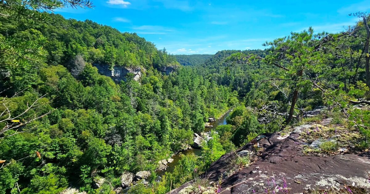
Mile 3.5 (3.7) Overlook spur. A short 125 foot spur trail on the left leads to an overlook with splendid views south up Daddys Creek Gorge and its mixed forest below. The fall colors can be spectacular and winter views without foliage provide an expansive look at the gorge. This is also a good spot for birders who want to glimpse raptors in flight. (El. 1,712′) N35 57.97, W84 50 33.41
Mile 3.6 (3.6) From the overlook spur, the trail begins a steady gentle descent into Daddys Creek Gorge.
Mile 3.7 (3.5) Cross a large wet weather drainage with stones for fording. Notice the small stone shelf on the right. Note the thin sedimentary layers visible in the rocks on the right before descending on stone steps.
Mile 3.8 (3.4) The trail veers away from Daddys Creek below to the left and leaves the older growth forest with its larger trees and then continues to descend into Daddys Creek Gorge.
Mile 4.0 (3.2) The trail passes rhododendron thickets on the right. Dense rhododendron thickets are called “hells” because they are so difficult to penetrate. The trail begins its final undulating descent before leveling out in the gorge. Trail joins Daddys Creek at N35 43.85, W84 51 00.28. Elevation 1,542′.
Mile 4.3 (2.9) For the next .9 mile, the trail follows Daddys Creek on the left through generally level terrain. Note that Daddys Creek flows north. There are stands of hemlock, white pine, rhododendron and mountain laurel as well as mixed hardwoods. There are interesting rock bluffs on the right along the way.
Mile 4.4 (2.8) The trail crosses Hatfield Branch which runs most of the time except in dry seasons. Just before the crossing there is a rock bluff on the right as you cross a drainage on stone steps.
Mile 4.5 (2.7) Note the old roadbed (Hatfield Road) on the right (east) leading up the hill. This area was Hatfield Ford across Daddys Creek, though no actual ford is visible today. There is a rockhouse on the right just after Hatfield Ford. A nice stone bench is here on the edge of the creek.
Side trip: Hike up hill on abandoned Hatfield Road for about 800 feet. After a slight bend to the right make a HARD LEFT at the T intersection. Hike on the overgrown road bed for about 200 feet and enter an abandoned surface mine that extends for more than 1,000 feet with a 70 foot high quarry face. The mine closed in the mid 1980s. It is now part of Cumberland Trail property.
Mile 4.6 (2.6) Cross two wet weather drainages separated about 150 feet and then shortly descend on some stone steps.
Mile 4.7 (2.5) After crossing another wet weather drainage, pass through a nice stand of Hemlock. Note some Woolly Adelgid damage. There is a small rock house just ahead on the right.
Mile 4.8 (2.4) Continue with rock bluffs on the right and cross another small wet weather drainage.
Mile 5.0 (2.2) Primitive campsite. (N35 58 32.916 W84 50 57.75) Tent sites are designated with signage. There is no potable water at this campsite. Campers must obtain a permit before camping overnight anywhere along the Cumberland Trail.
Mile 5.1 (2.1) Cross two wet weather drainages in quick succession.
Mile 5.2 (2.0) Shortly, the trail will veer away from Daddys Creek and begin to ascend. This area is known as Barnes Ford and there is an old road that can be seen ascending on the right.
Mile 5.3 (1.9) Switchback as the trail ascends.
Mile 5.5 (1.7) Switchback again as the trail continues to ascend.
Mile 5.6 (1.6) The trail levels for about .1 mile.
Mile 5.9 (1.3) Ascend slightly through mixed hardwood forest.
Mile 6.0 Enter the Keyes-Harrison WMA. (N35 58.81 W84 50.380). Hikers are required to wear florescent orange during big game season. Check the TWRA web site for big game season dates: https://www.tn.gov/twra/section/hunting-in-tennessee or call TWRA District 3 office at 931 456 3069.
Mile 6.1 (1.1) Cross an unnamed small branch that is usually dry except in wet weather.
Mile 6.3 (0.9) Ascend slightly and then switchback across Rocky Branch.
Mile 6.4 (0.8) Continue gentle ascent and then switchback at a small drainage. Note the large chestnut oak and large red oak nearby. The trail undulates along the ridge among recent growth hickory, oak, maple and hemlock.
Mile 7.1 (.1) Cross under power lines.
Mile 7.2 (0.0) Trail emerges onto East Keyes Road. Eventually, the trail will continue north via a road walk into the Catoosa Wildlife Management Area.
More Information
There is one authorized overnight campsite beside Daddys Creek 5.0 miles North of the Southern terminus (trailhead under the power lines at Hebbertsburg Road) and 2.6 miles North of the connector trail junction. Tent sites are designated with signage. There is no potable water at this campsite although it is next to the creek. Boil or filter creek water first. Please practice “Leave no Trace” principles when hiking and camping on the trail. Camping on the Cumberland Trail is by permit only. Permits and vehicle overnight parking registration can be obtained online at http://www.friendsofthecumberlandtrail.org/camping/.